
File:Hells Half Acre, Fort Worth, Texas Historical Marker (7006958981).jpg

Size of this preview: 400 × 600 pixels. Other resolutions: 160 × 240 pixels | 320 × 480 pixels | 512 × 768 pixels | 682 × 1,024 pixels | 1,365 × 2,048 pixels | 3,456 × 5,184 pixels.
Original file (3,456 × 5,184 pixels, file size: 7.72 MB, MIME type: image/jpeg)
| This is a file from the Wikimedia Commons. Information from its description page there is shown below. Commons is a freely licensed media file repository. You can help. |
.jpg)
Summary
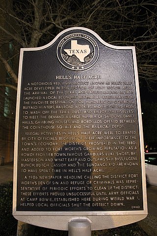
| Description | A notorious red light district known as Hell's Half Acre developed in this section of Fort Worth after the arrival of the Texas and Pacific Railway in 1876 launched a local economic boom. Fort Worth was soon the favorite destination for hundreds of cowboys, buffalo hunters, railroad workers, and freighters eager to wash off the trail dust and enjoy themselves. To meet the demand, a large number of saloons, dance halls, gambling houses, and bordellos opened between the Courthouse Square and the railroad depot. Illegal activities in Hell's Half Acre were tolerated by city officials because of their importance to the town's economy. The district prospered in the 1880s and added to Fort Worth's growing reputation as a rowdy frontier town. Famous gamblers Luke Short, Bat Masterson and Wyatt Earp and outlaws Sam Bass, Eugene Bunch, Butch Cassidy and the Sundance Kid are known to have spent time in Hell's Half Acre. A 1906 newspaper headline calling the district Fort Worth's den of sin and refuge of criminals was representative of periodic efforts to clean up the district. These efforts proved unsuccessful until Army officials at Camp Bowie, established here during World War I, helped local officials shut the district down. (1993) |
| Date | |
| Source |
Hell's Half Acre, Fort Worth, Texas Historical Marker
|
| Author | Nicolas Henderson from Coppell, Texas |
| Camera location | | View this and other nearby images on: OpenStreetMap |
|---|
.jpg¶ms=032.748238_N_-097.327762_E_globe:Earth_type:camera_source:Flickr_&language=en)
Licensing
This file is licensed under the Creative Commons Attribution 2.0 Generic license.
- You are free:
- to share – to copy, distribute and transmit the work
- to remix – to adapt the work
- Under the following conditions:
- attribution – You must give appropriate credit, provide a link to the license, and indicate if changes were made. You may do so in any reasonable manner, but not in any way that suggests the licensor endorses you or your use.
| This image, originally posted to Flickr, was reviewed on 16 November 2013 by the administrator or reviewer File Upload Bot (Magnus Manske), who confirmed that it was available on Flickr under the stated license on that date. |
File history
Click on a date/time to view the file as it appeared at that time.
| Date/Time | Thumbnail | Dimensions | User | Comment | |
|---|---|---|---|---|---|
| current | 02:00, 16 November 2013 | | 3,456 × 5,184 (7.72 MB) | File Upload Bot (Magnus Manske) | Transferred from Flickr by User:AlbertHerring |
File usage
The following pages on the English Wikipedia use this file (pages on other projects are not listed):
Global file usage
The following other wikis use this file:
- Usage on www.wikidata.org
.jpg)