
File:First GOES-17 Magnetometer Data (41237860081).png

Original file (2,330 × 1,612 pixels, file size: 164 KB, MIME type: image/png)
| This is a file from the Wikimedia Commons. Information from its description page there is shown below. Commons is a freely licensed media file repository. You can help. |
.png)
Summary
| Description |
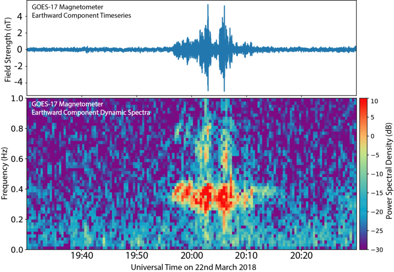
On March 22, 2018, the GOES-17 Magnetometer (MAG) became the first instrument on the satellite to begin transmitting data! This figure shows data from the outboard Magnetometer instrument on board the GOES-17 satellite. The data has been filtered to highlight a space weather phenomenon known as plasma waves. These waves play a significant role in controlling the levels of dangerous energetic particles that can cause damage to satellites and harm astronauts. An important characteristic of these waves is how fast they oscillate up and down or their frequency (shown in the bottom panel of the figure). The Magnetometers on the GOES-R Series of satellites, with five times higher resolution, can observe more wave frequencies allowing us to undertake research into new space weather products that help forecasters better determine the likelihood that elevated levels of dangerous energetic particles will occur during space weather events. Credit: NOAA/NASA Learn more about the GOES-16's magnetometer at <a href="http://www.goes-r.gov/spacesegment/mag.html" rel="nofollow">www.goes-r.gov/spacesegment/mag.html</a> Note: This is preliminary, non-operational data as GOES-17 undergoes on-orbit testing. |
| Date | |
| Source | First GOES-17 Magnetometer Data |
| Author | NOAA Satellites |
Licensing
This image is in the public domain because it contains materials that originally came from the U.S. National Oceanic and Atmospheric Administration, taken or made as part of an employee's official duties.
|
| This image was originally posted to Flickr by NOAASatellites at https://flickr.com/photos/125201706@N06/41237860081 (archive). It was reviewed on 18 September 2018 by FlickreviewR 2 and was confirmed to be licensed under the terms of the Public Domain Mark. |
File history
Click on a date/time to view the file as it appeared at that time.
| Date/Time | Thumbnail | Dimensions | User | Comment | |
|---|---|---|---|---|---|
| current | 21:20, 17 September 2018 | | 2,330 × 1,612 (164 KB) | MarginalCost | Transferred from Flickr via #flickr2commons |
.png)