
File:Europe, 1714.png
Size of this preview: 800 × 546 pixels. Other resolutions: 320 × 219 pixels | 640 × 437 pixels | 1,024 × 699 pixels | 1,280 × 874 pixels | 1,590 × 1,086 pixels.
Original file (1,590 × 1,086 pixels, file size: 986 KB, MIME type: image/png)
| This is a file from the Wikimedia Commons. Information from its description page there is shown below. Commons is a freely licensed media file repository. You can help. |

|
This map of europe image could be re-created using vector graphics as an SVG file. This has several advantages; see Commons:Media for cleanup for more information. If an SVG form of this image is available, please upload it and afterwards replace this template with
{{vector version available|new image name}}.
It is recommended to name the SVG file “Europe, 1714.svg”—then the template Vector version available (or Vva) does not need the new image name parameter. |
_en.png)
.png)
.jpg)
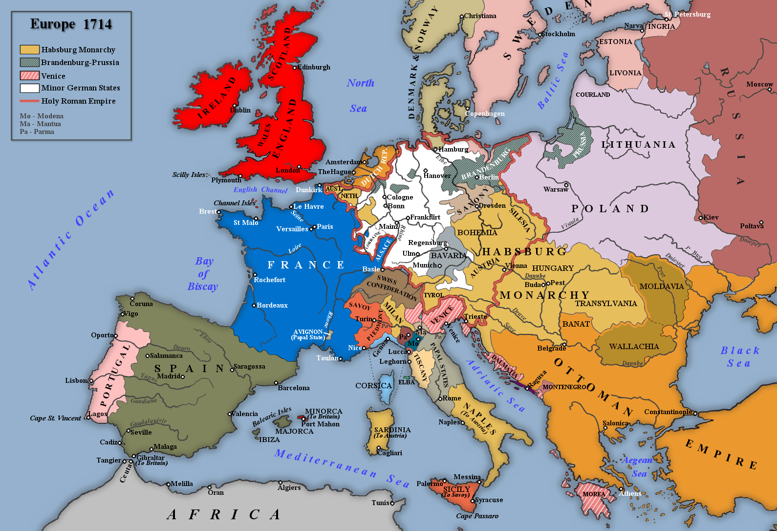
Summary
| Description |
English: Map of Europe in 1714 |
| Date | |
| Source | Own work |
| Author | Rebel Redcoat |
Licensing
| I, the copyright holder of this work, release this work into the public domain. This applies worldwide. In some countries this may not be legally possible; if so: I grant anyone the right to use this work for any purpose, without any conditions, unless such conditions are required by law. |
File history
Click on a date/time to view the file as it appeared at that time.
| Date/Time | Thumbnail | Dimensions | User | Comment | |
|---|---|---|---|---|---|
| current | 17:42, 2 May 2014 | | 1,590 × 1,086 (986 KB) | Spiridon Ion Cepleanu | According with H.E.Stier (dir.) Grosser Atlas zur Weltgeschichte, Westermann 1984, p.119, ISBN 3141009198, & all sources, the Danubian principalities were not turkish provinces but christian states (ruled by Greek hospodars), vassal of the Ottoman sult... |
| 19:21, 7 January 2014 |  | 1,590 × 1,086 (1.07 MB) | Rebel Redcoat~commonswiki | Some minor improvements/accuracy | |
| 11:59, 17 January 2013 |  | 1,590 × 1,086 (1.06 MB) | Rebel Redcoat~commonswiki | Added St. Petersburg | |
| 15:00, 26 May 2012 |  | 1,590 × 1,086 (1.06 MB) | Rebel Redcoat~commonswiki | Correction: Sicily | |
| 18:48, 6 May 2012 |  | 1,590 × 1,086 (1.06 MB) | Rebel Redcoat~commonswiki | Better quality | |
| 23:30, 17 June 2010 |  | 1,594 × 1,090 (222 KB) | Rebel Redcoat~commonswiki | {{Information |Description={{en|1=Map of Europe in 1714}} |Source={{own}} |Author=Rebel Redcoat |Date=18 June 2010 |Permission= |other_versions= }} Category:Maps |
File usage
The following pages on the English Wikipedia use this file (pages on other projects are not listed):
Global file usage
The following other wikis use this file:
- Usage on ar.wikipedia.org
- Usage on bg.wikipedia.org
- Usage on ca.wikipedia.org
- Usage on fa.wikipedia.org
- Usage on fr.wikipedia.org
- Usage on gcr.wikipedia.org
- Usage on id.wikipedia.org
- Usage on ja.wikipedia.org
- Usage on mk.wikipedia.org
- Usage on nl.wikipedia.org
- Usage on nn.wikipedia.org
- Usage on ru.wikipedia.org
- Usage on sh.wikipedia.org
- Usage on tr.wikipedia.org
- Usage on uk.wikipedia.org
- Usage on www.wikidata.org