
File:Crumlin (Low Level) station and Crumlin Viaduct geograph-2986824-by-Ben-Brooksbank.jpg
Size of this preview: 800 × 551 pixels. Other resolutions: 320 × 220 pixels | 640 × 441 pixels | 1,024 × 705 pixels | 1,280 × 881 pixels | 2,106 × 1,450 pixels.
Original file (2,106 × 1,450 pixels, file size: 1.26 MB, MIME type: image/jpeg)
| This is a file from the Wikimedia Commons. Information from its description page there is shown below. Commons is a freely licensed media file repository. You can help. |
_station_and_Crumlin_Viaduct_geograph-2986824-by-Ben-Brooksbank.jpg)
Summary
| Description |
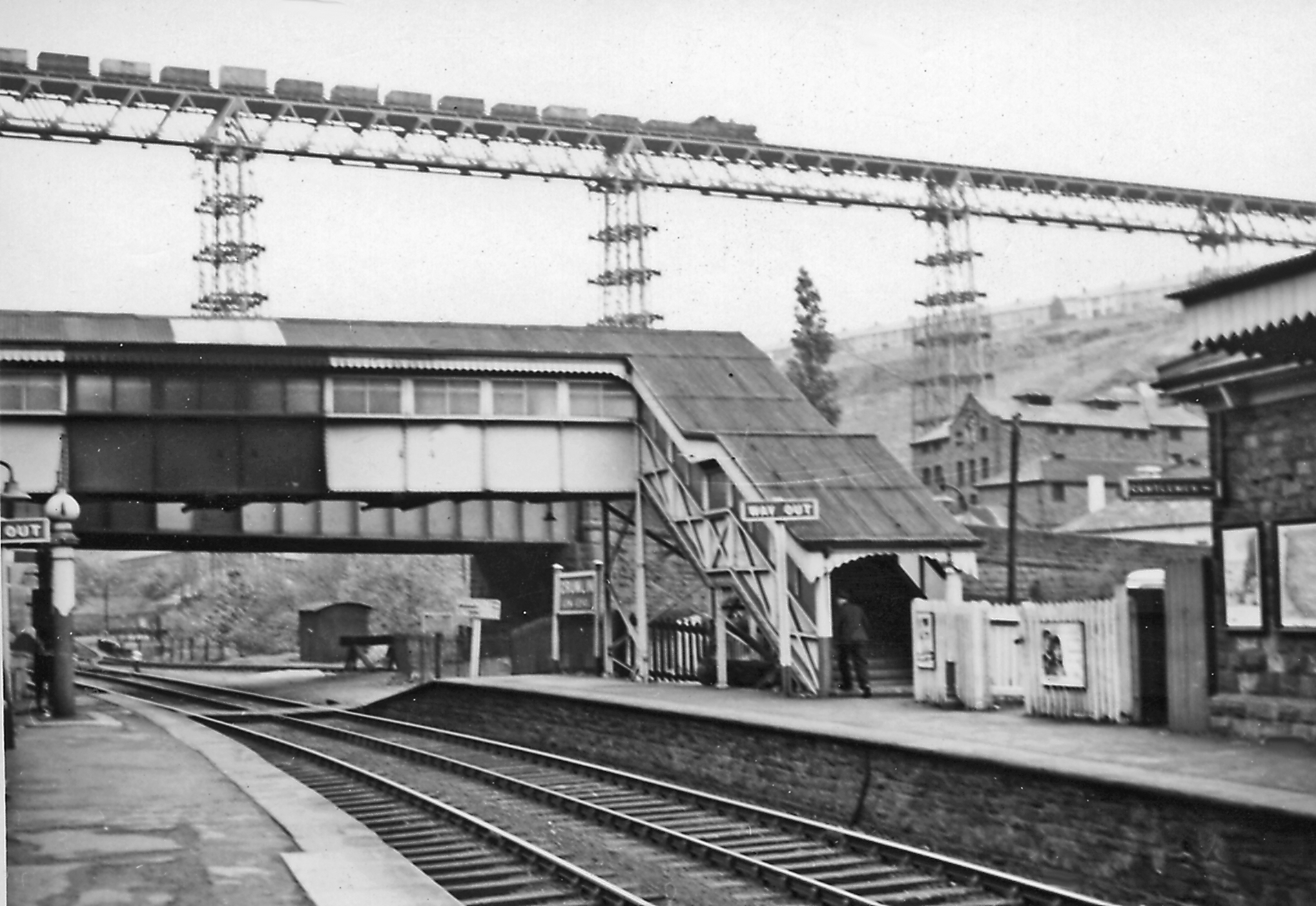
English: Crumlin (Low Level) station and Crumlin Viaduct. View NE, towards Aberbeeg and Ebbw Vale/Brynmawr on the ex-GW Newport - Western Valleys lines. The station and both lines closed to passengers from 30/4/62. Freight ceased on the Ebbw Fach line in 1975, but has continued to Ebbw Vale. On the restored passenger service to Ebbw Vale, commencing on 6/2/08, the nearest station is Newbridge. High up on the celebrated viaduct of the ex-GW Neath - Pontypool Road line, just east of Crumlin (High Level), is an eastbound coal train - looking very perilous. (See also 2986887). |
| Date | Taken on 11 May 1957 |
| Source | From geograph.org.uk |
| Author | Ben Brooksbank |
| Permission (Reusing this file) |
Creative Commons Attribution Share-alike license 2.0 |
| Camera location | | View this and other nearby images on: OpenStreetMap |
|---|
_station_and_Crumlin_Viaduct_geograph-2986824-by-Ben-Brooksbank.jpg¶ms=051.676981_N_-003.144801_E_globe:Earth_type:camera_heading:45.00&language=en)
Licensing

|
This image was taken from the Geograph project collection. See this photograph's page on the Geograph website for the photographer's contact details. The copyright on this image is owned by Ben Brooksbank and is licensed for reuse under the Creative Commons Attribution-ShareAlike 2.0 license.
|
This file is licensed under the Creative Commons Attribution-Share Alike 2.0 Generic license.
Attribution: Ben Brooksbank
- You are free:
- to share – to copy, distribute and transmit the work
- to remix – to adapt the work
- Under the following conditions:
- attribution – You must give appropriate credit, provide a link to the license, and indicate if changes were made. You may do so in any reasonable manner, but not in any way that suggests the licensor endorses you or your use.
- share alike – If you remix, transform, or build upon the material, you must distribute your contributions under the same or compatible license as the original.
File history
Click on a date/time to view the file as it appeared at that time.
| Date/Time | Thumbnail | Dimensions | User | Comment | |
|---|---|---|---|---|---|
| current | 18:29, 13 June 2012 | | 2,106 × 1,450 (1.26 MB) | Chevin | == {{int:filedesc}} == {{Information |Description={{en|1='''Crumlin (Low Level) station and Crumlin Viaduct.'''<br/> View NE, towards Aberbeeg and Ebbw Vale/Brynmawr on the ex-GW Newport - Western Valleys lines. The station and both lines closed to pas... |
File usage
The following pages on the English Wikipedia use this file (pages on other projects are not listed):
Global file usage
The following other wikis use this file:
- Usage on de.wikipedia.org
- Usage on es.wikipedia.org
- Usage on www.wikidata.org
_station_and_Crumlin_Viaduct_geograph-2986824-by-Ben-Brooksbank.jpg)