
File:Charles W. Jefferys's map of lower Humber Toronto.jpg

Size of this preview: 800 × 600 pixels. Other resolutions: 320 × 240 pixels | 640 × 480 pixels | 1,024 × 768 pixels | 1,280 × 960 pixels | 2,560 × 1,920 pixels | 4,608 × 3,456 pixels.
Original file (4,608 × 3,456 pixels, file size: 5.91 MB, MIME type: image/jpeg)
| This is a file from the Wikimedia Commons. Information from its description page there is shown below. Commons is a freely licensed media file repository. You can help. |
Summary
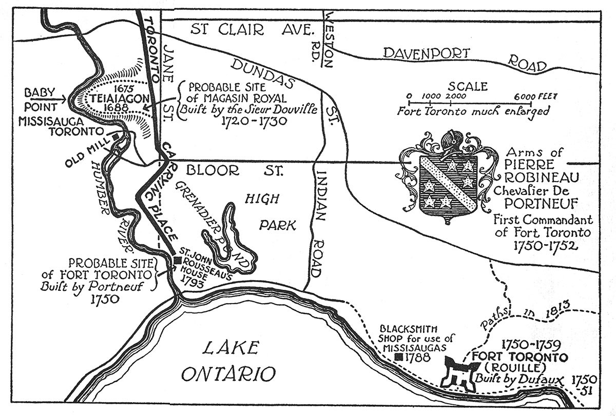
| Description | Map Showing Position of French Posts at Toronto | ||||||||||||||||||||
| Date | (originally published in: Jefferys, Charles W. (1942), The Picture Gallery of Canadian History Volume 1, p.218) | ||||||||||||||||||||
| Source | Jack Gibney, The History and Future of Transit On Humber Bay, Sunnyside Historical Society (image 4068 x 3456 pixels) | ||||||||||||||||||||
| Author |
|
||||||||||||||||||||
| Permission (Reusing this file) |
|
||||||||||||||||||||
| Other versions |
|
||||||||||||||||||||
.jpg)

File history
Click on a date/time to view the file as it appeared at that time.
| Date/Time | Thumbnail | Dimensions | User | Comment | |
|---|---|---|---|---|---|
| current | 19:27, 10 November 2019 | | 4,608 × 3,456 (5.91 MB) | Jon Kolbert | better quality version |
| 17:42, 6 November 2019 |  | 600 × 456 (54 KB) | Geo Swan | {{Information |Description=Pierre Robineau's map of lower Humber Toronto. |Source=https://taiaiakon.wordpress.com/2012/09/19/taiaiaikon/ |Date=1750s |Author=Pierre Robineau |Permission={{PD-Canada}} |other_versions= }} Category:Pierre Robineau Category:Old maps of Toronto Waterfront Category:Humber Bay Category:Toronto Carrying Place Category:Humber River (Ontario) |
File usage
The following pages on the English Wikipedia use this file (pages on other projects are not listed):
Global file usage
The following other wikis use this file:
- Usage on fr.wikipedia.org