
File:British Rail York to Leeds via Harrogate diagram with closed stations and lines indicated.png
Size of this preview: 454 × 599 pixels. Other resolutions: 182 × 240 pixels | 364 × 480 pixels | 582 × 768 pixels | 776 × 1,024 pixels | 1,919 × 2,532 pixels.
Original file (1,919 × 2,532 pixels, file size: 217 KB, MIME type: image/png)
| This is a file from the Wikimedia Commons. Information from its description page there is shown below. Commons is a freely licensed media file repository. You can help. |
Summary
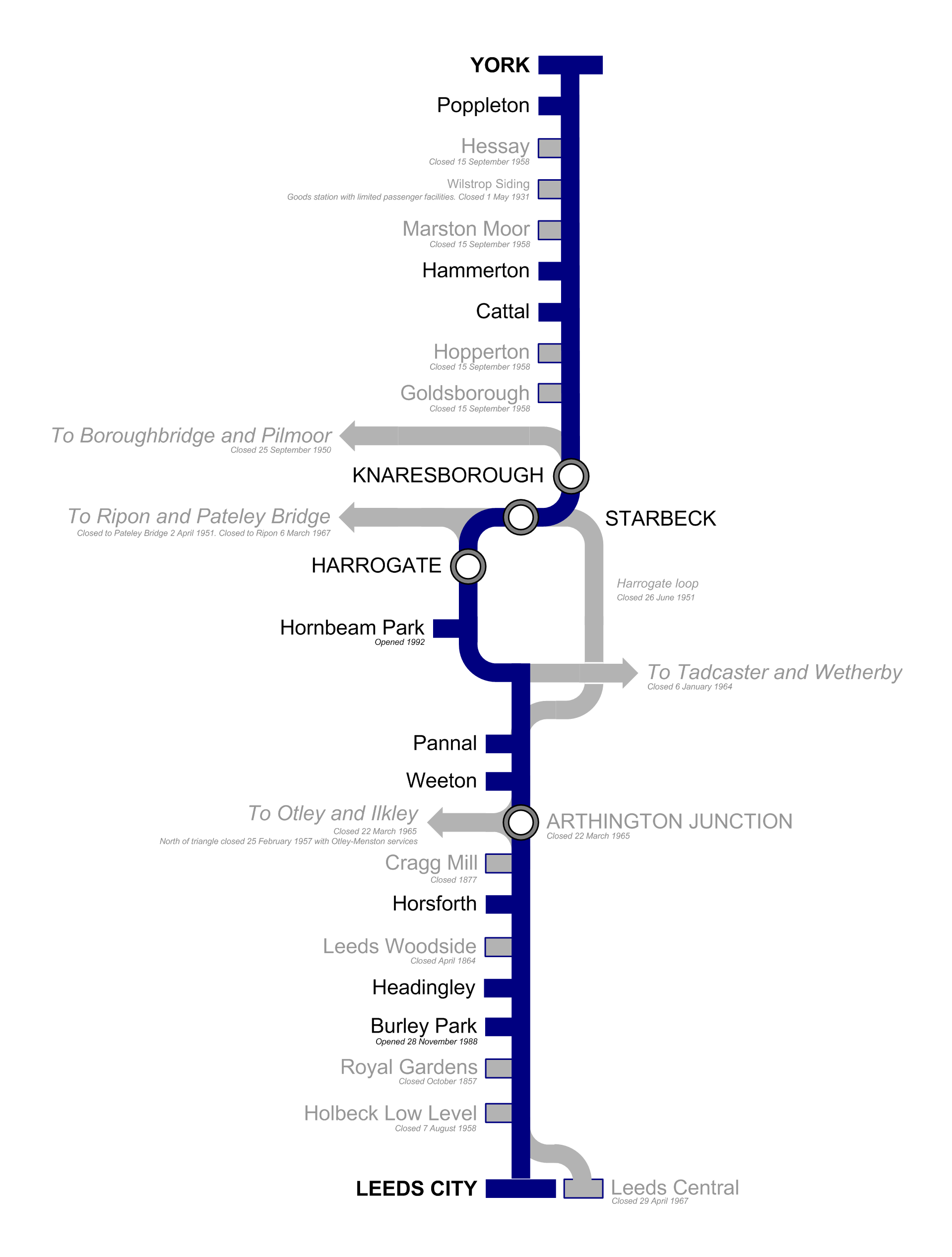
| Description | British Rail York to Leeds line via Harrogate diagram map, with closed stations and lines indicated. |
| Date | 15 January 2006 (original upload date) |
| Source | No machine-readable source provided. Own work assumed (based on copyright claims). |
| Author | No machine-readable author provided. Redvers assumed (based on copyright claims). |
Licensing
| I, the copyright holder of this work, release this work into the public domain. This applies worldwide. In some countries this may not be legally possible; if so: I grant anyone the right to use this work for any purpose, without any conditions, unless such conditions are required by law. |
File history
Click on a date/time to view the file as it appeared at that time.
| Date/Time | Thumbnail | Dimensions | User | Comment | |
|---|---|---|---|---|---|
| current | 10:18, 12 February 2006 | | 1,919 × 2,532 (217 KB) | Redvers | Update following [http://en.wikipedia.org/w/index.php?title=User_talk:Redvers&oldid=39253129#Harrogate_Line_article_map this message] on my en-Wikipedia talk page. |
| 14:28, 1 February 2006 |  | 1,919 × 2,532 (217 KB) | Redvers | Updated to reflect further closed stations and depict Harrogate Loop and Pannal Junction more clearly. | |
| 11:04, 16 January 2006 |  | 1,476 × 1,476 (200 KB) | Redvers | Correcting a small error. | |
| 16:13, 15 January 2006 |  | 2,953 × 2,953 (389 KB) | Redvers | Larger, more detailed version closer to actual geography. | |
| 01:18, 15 January 2006 |  | 1,357 × 1,891 (133 KB) | Redvers | British Rail York to Leeds line via Harrogate diagram, with closed stations and lines indicated. |
File usage
The following pages on the English Wikipedia use this file (pages on other projects are not listed):
Global file usage
The following other wikis use this file:
- Usage on hu.wikipedia.org