
File:Bishop Auckland 2 railway station1805267 f99ac746.jpg
No higher resolution available.
Bishop_Auckland_2_railway_station1805267_f99ac746.jpg (640 × 409 pixels, file size: 119 KB, MIME type: image/jpeg)
| This is a file from the Wikimedia Commons. Information from its description page there is shown below. Commons is a freely licensed media file repository. You can help. |
Summary
| Description |
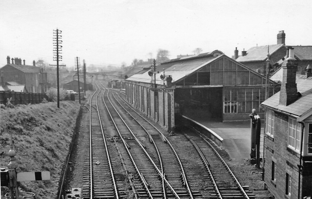
English: Bishop Auckland Station. View westward; important junction with triangular station, closed 6/6/86 and replaced by a terminal platform just for the service from Darlington. Lines used to run eastward to Stockton via Simpasture and Stillington (goods only, closed 22/6/83), southward to Barnard Castle (closed 18/6/62) and Ferryhill via Spennymoor (closed to Spennymoor 4/12/39, Ferryhill 31/3/52 (goods 2/5/66); westwards to Wearhead (closed to passengers 29/6/53, to Etherley 3/65), goods (to Eastgate) 1992, northwards to Consett and Newcastle via Swalwell (passengers until 5/39, cut back to Tow Law 11/6/56, then Crook (8/3/65), and to Durham via Relly Mill Junction (closed to passengers 4/5/64, goods 5/8/68). |
| Date | |
| Source | From geograph.org.uk |
| Author | Ben Brooksbank |
| Permission (Reusing this file) |
Creative Commons Attribution Share-alike license 2.0 |
| Camera location | | View this and other nearby images on: OpenStreetMap |
|---|
Licensing

|
This image was taken from the Geograph project collection. See this photograph's page on the Geograph website for the photographer's contact details. The copyright on this image is owned by Ben Brooksbank and is licensed for reuse under the Creative Commons Attribution-ShareAlike 2.0 license.
|
This file is licensed under the Creative Commons Attribution-Share Alike 2.0 Generic license.
Attribution: Ben Brooksbank
- You are free:
- to share – to copy, distribute and transmit the work
- to remix – to adapt the work
- Under the following conditions:
- attribution – You must give appropriate credit, provide a link to the license, and indicate if changes were made. You may do so in any reasonable manner, but not in any way that suggests the licensor endorses you or your use.
- share alike – If you remix, transform, or build upon the material, you must distribute your contributions under the same or compatible license as the original.
File history
Click on a date/time to view the file as it appeared at that time.
| Date/Time | Thumbnail | Dimensions | User | Comment | |
|---|---|---|---|---|---|
| current | 16:22, 13 November 2010 | | 640 × 409 (119 KB) | Chevin | == {{int:filedesc}} == {{Information |Description={{en|1=Bishop Auckland Station View westward; important junction with triangular station, closed 6/6/86 and replaced by a terminal platform just for the service from Darlington. Lines used to run eastward |
File usage
The following pages on the English Wikipedia use this file (pages on other projects are not listed):
Global file usage
The following other wikis use this file:
- Usage on de.wikipedia.org