
File:Africa Roman map.svg

Original file (SVG file, nominally 2,500 × 650 pixels, file size: 311 KB)
| This is a file from the Wikimedia Commons. Information from its description page there is shown below. Commons is a freely licensed media file repository. You can help. |
Summary
| Description |
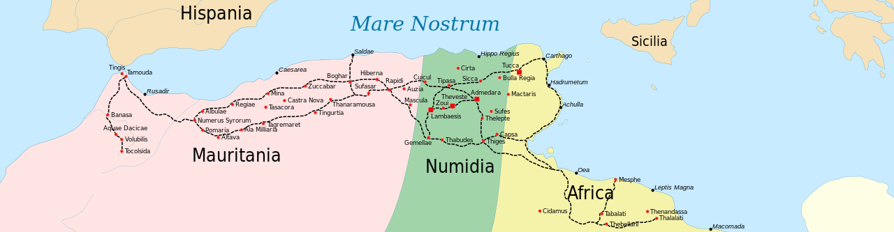
Català: Mapa antic del Nord d'Àfrica. Mapa de les vies romanes dels limes imperials (segle II dC
English: Ancient map of the Northern Africa. Map of roman roads of imperial limes (IInd century AD
Français : Carte antique du nord africa. Carte avec les provinces romaines et les routes du limes africain au IIe siècle de notre ère
Lambert azimutal equal-area projection, WGS84 datum, standard meridian: 15°E, standard parallel: 0° |
||
| Date | |||
| Source |
Sting
|
||
| Author | Eric Gaba (Sting - fr:Sting), modified by Gigillo83 | ||
| Permission (Reusing this file) |
|
||
| Other versions |
File:Africa Roman map.svg has 2 translations.
Other related versions: []
|


|
This SVG file contains embedded text that can be translated into your language, using any capable SVG editor, text editor or the SVG Translate tool. For more information see: About translating SVG files. |
This file is translated using SVG <switch> elements. All translations are stored in the same file! Learn more.
For most Wikipedia projects, you can embed the file normally (without a To translate the text into your language, you can use the SVG Translate tool. Alternatively, you can download the file to your computer, add your translations using whatever software you're familiar with, and re-upload it with the same name. You will find help in Graphics Lab if you're not sure how to do this. |
Licensing

|
Permission is granted to copy, distribute and/or modify this document under the terms of the GNU Free Documentation License, Version 1.2 or any later version published by the Free Software Foundation; with no Invariant Sections, no Front-Cover Texts, and no Back-Cover Texts. A copy of the license is included in the section entitled GNU Free Documentation License. |
| This file is licensed under the Creative Commons Attribution-Share Alike 3.0 Unported license. | ||
| ||
| This licensing tag was added to this file as part of the GFDL licensing update. |
- You are free:
- to share – to copy, distribute and transmit the work
- to remix – to adapt the work
- Under the following conditions:
- attribution – You must give appropriate credit, provide a link to the license, and indicate if changes were made. You may do so in any reasonable manner, but not in any way that suggests the licensor endorses you or your use.
- share alike – If you remix, transform, or build upon the material, you must distribute your contributions under the same or compatible license as the original.
File history
Click on a date/time to view the file as it appeared at that time.
| Date/Time | Thumbnail | Dimensions | User | Comment | |
|---|---|---|---|---|---|
| current | 22:55, 14 February 2024 | 2,500 × 650 (311 KB) | Manlleus | File uploaded using svgtranslate tool (https://svgtranslate.toolforge.org/). Added translation for ca. | |
| 20:55, 25 March 2010 | 2,500 × 650 (259 KB) | Gigillo83 | Adding names | ||
| 22:04, 24 March 2010 | 2,500 × 650 (255 KB) | Gigillo83 | sistemazione | ||
| 22:03, 24 March 2010 | 2,500 × 650 (255 KB) | Gigillo83 | Adjusting file | ||
| 22:00, 24 March 2010 | 2,500 × 750 (252 KB) | Gigillo83 | Adding names, roads and borders | ||
| 21:55, 8 March 2010 | 2,500 × 750 (210 KB) | Gigillo83 | Zoom mappa | ||
| 21:54, 8 March 2010 | 2,500 × 750 (210 KB) | Gigillo83 | Aggiornamento file | ||
| 21:17, 15 February 2010 | 3,266 × 1,039 (312 KB) | Gigillo83 | == {{int:filedesc}} == {{Information |Description={{en|Ancient map of the Northern Africa.}} {{fr|Carte antique du nord africa.}} Lambert azimutal equal-area projection, WGS84 datum, standard merid |
File usage
Global file usage
The following other wikis use this file:
- Usage on ar.wikipedia.org
- Usage on ary.wikipedia.org
- Usage on ca.wikipedia.org
- Usage on de.wikipedia.org
- Usage on es.wikipedia.org
- Usage on fr.wikipedia.org
- Usage on it.wikipedia.org
- Usage on www.wikidata.org