
File:ARIPO and OAPI.png

Size of this preview: 800 × 370 pixels. Other resolutions: 320 × 148 pixels | 640 × 296 pixels | 1,357 × 628 pixels.
Original file (1,357 × 628 pixels, file size: 27 KB, MIME type: image/png)
| This is a file from the Wikimedia Commons. Information from its description page there is shown below. Commons is a freely licensed media file repository. You can help. |
Summary
| Description |
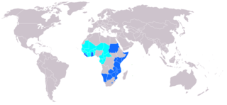
English: ARIPO and OAPI members as of Oct. 30, 2007. ARIPO members in blue; OAPI members in cyan. |
| Date | 30 October 2007 (original upload date) |
| Source | Own work, based on Image:African_Regional_Intellectual_Property_Organization.png by User:Ekrub-ntyh |
| Author | User:Cxw |
Licensing
| This work has been released into the public domain by its author, Cxw. This applies worldwide. In some countries this may not be legally possible; if so: |
Original upload log
Transferred from en.wikipedia to Commons using FtCG.
The original description page was here. All following user names refer to en.wikipedia.
| Date/Time | Dimensions | User | Comment |
|---|---|---|---|
| 12:51, 30 October 2007 | 1,357 × 628 (54,180 bytes) | w:en:Cxw (talk | contribs) | (ARIPO and OAPI members as of Oct. 30, 2007. ARIPO members in blue; OAPI members in cyan. Based on [[Image:African_Regional_Intellectual_Property_Organization.png]] by [[User:Ekrub-ntyh]].) |
File history
Click on a date/time to view the file as it appeared at that time.
| Date/Time | Thumbnail | Dimensions | User | Comment | |
|---|---|---|---|---|---|
| current | 09:27, 8 February 2019 | | 1,357 × 628 (27 KB) | Chtrede | updates as of Feb 2019 ARIPO: +Namibia +Liberia +Sao OAPI: +Comoros |
| 23:16, 29 January 2014 |  | 1,357 × 628 (28 KB) | Maproom | More changes requested at https://en.wikipedia.org/wiki/Wikipedia:Graphics_Lab/Map_workshop#Erroneous_map : "South Sudan should be in grey." "The Republic of the Congo should be in cyan (as an OAPI member state)." | |
| 23:56, 23 January 2014 |  | 1,357 × 628 (42 KB) | Maproom | Formerly green countries, and Congo-Kinshasa. made grey, as requested at https://en.wikipedia.org/wiki/Wikipedia:Graphics_Lab/Map_workshop#Erroneous_map | |
| 08:30, 8 June 2012 |  | 1,357 × 628 (53 KB) | Bulwersator | Transferred from en.wikipedia: see original upload log above |
File usage
The following pages on the English Wikipedia use this file (pages on other projects are not listed):
Global file usage
The following other wikis use this file:
- Usage on ar.wikipedia.org
- Usage on de.wikipedia.org
- Usage on es.wikipedia.org
- Usage on fr.wikipedia.org
- Usage on www.wikidata.org