
File:AMH-7131-NA Map of Spanish fort at Tamsui, later in hands of the VOC.jpg

Original file (9,167 × 6,437 pixels, file size: 9.08 MB, MIME type: image/jpeg)
| This is a file from the Wikimedia Commons. Information from its description page there is shown below. Commons is a freely licensed media file repository. You can help. |
Summary
Nederlands: Kaartje van het Spaanse fort te Tamsui, later van de VOC
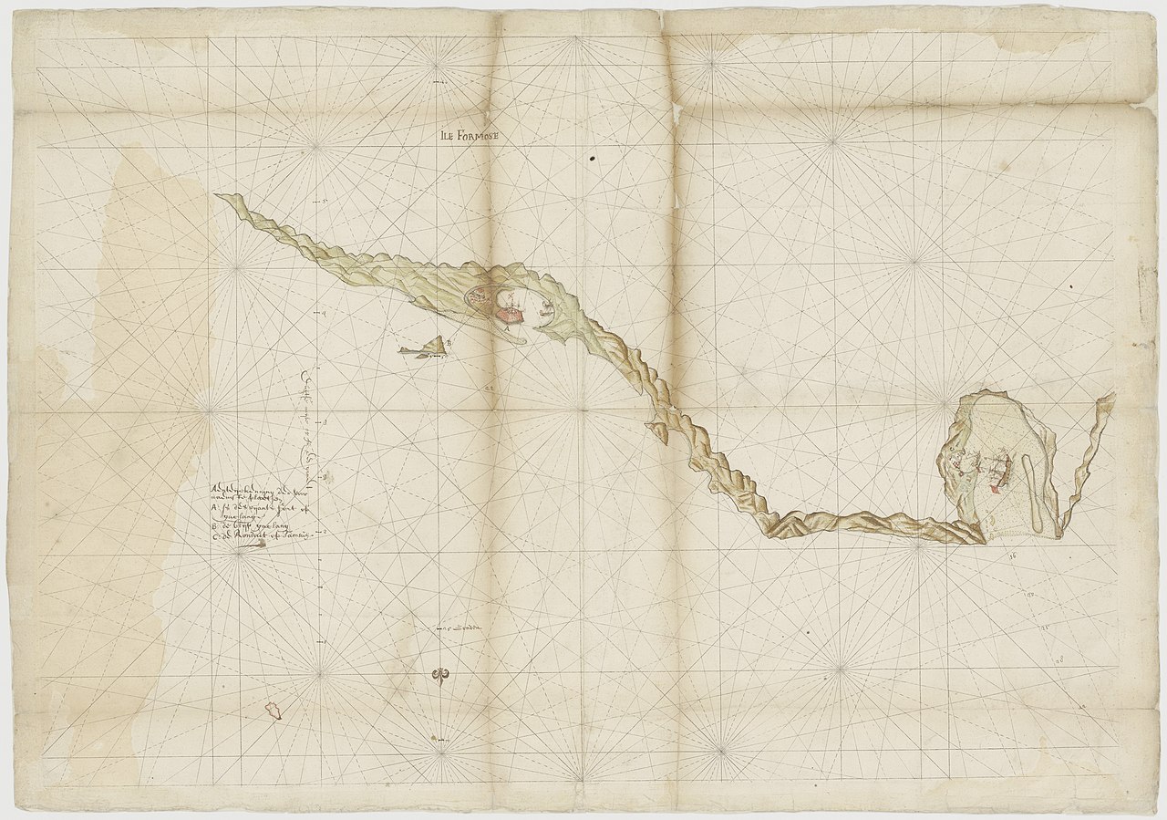
English: Map of Spanish fort at Tamsui, later in hands of the VOC( |
||||||||||||||||||||||||
|---|---|---|---|---|---|---|---|---|---|---|---|---|---|---|---|---|---|---|---|---|---|---|---|---|
| Author |
Nederlands: Anoniem / Anonymous (landmeter / kaartenmaker)
English: Anoniem / Anonymous (land surveyor / mapmaker) |
|||||||||||||||||||||||
| Title |
Nederlands: Kaartje van het Spaanse fort te Tamsui, later van de VOC
English: Map of Spanish fort at Tamsui, later in hands of the VOC |
|||||||||||||||||||||||
| Description |
Nederlands: Titel catalogus Leupe (NA): Caerte van des vijants gelegentheijt op Quelang ende Tangswij op het noorteijnde van Isla Formosa.
De schaal zou ook kunnen zijn 5 Duitse mijlen = 292 strepen; omgerekende schaal [1: 130.976]. Notities verso: caerte van des vijants gelegentheijt op Quelang ende Tangswij op het noort eijnde van Isla Formosa / No. 33 [volgnummer van het stuk in de band ?] / uit overgekomen br. en papieren 1630 QQII / 230 [folionummer in de band]. Notitie in catalogus Leupe: VOC 1098.English: Title in the Leupe catalogue (NA): Caerte van des vijants gelegentheijt op Quelang ende Tangswij op het noorteijnde van Isla Formosa.
The scale could also be 5 German miles = 292 stripes; converted scale [1: 130.976]. Notes on reverse: caerte van des vijants gelegentheijt op Quelang ende Tangswij op het noort eijnde van Isla Formosa / No. 33 [serial number of the item in the volume?] / uit overgekomen br. en papieren 1630 QQII / 230 [folio number in the volume]. Note in the Leupe catalogue: VOC 1098. |
|||||||||||||||||||||||
| Date | circa 1630 | |||||||||||||||||||||||
| Medium |
Nederlands: ingekleurde tekening op papier
English: coloured drawing on paper |
|||||||||||||||||||||||
| Dimensions | height: 76 cm (29.9 in); width: 53 cm (20.8 in) | |||||||||||||||||||||||
| Collection |
|
|||||||||||||||||||||||
| Accession number |
NL-HaNA_4.VELH_141 (old number: VELH0141) |
|||||||||||||||||||||||
| Notes |
English: Subjects: chart / map / plan, fortification, key
Nederlands: Onderwerpen: plattegrond / kaart, vesting, legenda |
|||||||||||||||||||||||
| Source/Photographer |
|
|||||||||||||||||||||||
| Permission (Reusing this file) |
|
|||||||||||||||||||||||
| Other versions |
|
|||||||||||||||||||||||


| Object location | | View this and other nearby images on: OpenStreetMap |
|---|
File history
Click on a date/time to view the file as it appeared at that time.
| Date/Time | Thumbnail | Dimensions | User | Comment | |
|---|---|---|---|---|---|
| current | 10:11, 16 May 2017 | | 9,167 × 6,437 (9.08 MB) | Timmietovenaar | Higher Resolution |
| 09:57, 11 June 2014 |  | 2,400 × 2,135 (529 KB) | HuskyBot | == {{int:filedesc}} == {{Artwork |title = {{nl|1=Kaartje van het Spaanse fort te Tamsui, later van de VOC}} {{en|1=Map of Spanish fort at Tamsui, later in hands of the VOC}} |description = {{nl|1=Titel catalogu... |