
File:Semmering-Basistunnel.png

Size of this preview: 800 × 484 pixels. Other resolutions: 320 × 194 pixels | 640 × 387 pixels | 1,024 × 620 pixels | 1,280 × 775 pixels | 2,400 × 1,453 pixels.
Original file (2,400 × 1,453 pixels, file size: 897 KB, MIME type: image/png)
| This is a file from the Wikimedia Commons. Information from its description page there is shown below. Commons is a freely licensed media file repository. You can help. |
Summary
| Description |
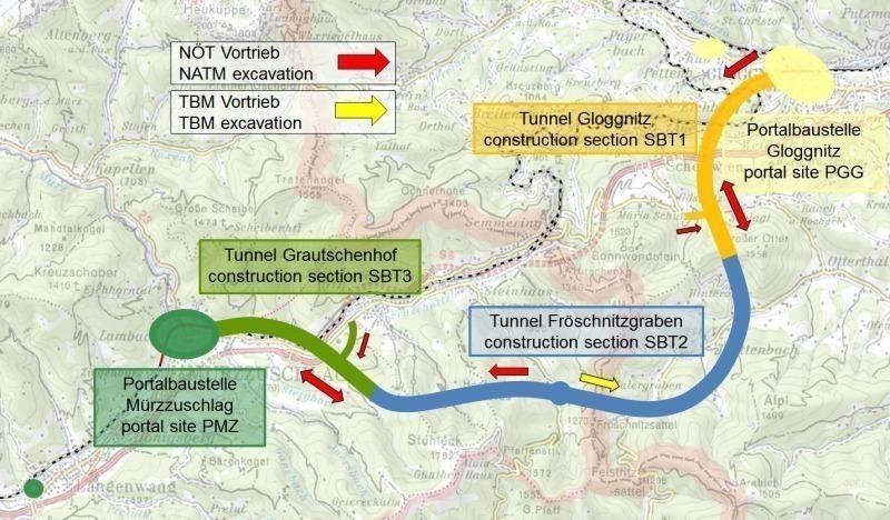
Deutsch: Karte des Semmering-Basistunnels
English: Map of the Semmering Base Tunnel |
|||
| Date | ||||
| Source |
Own work, using
|
|||
| Author | Földhegy | |||
| Permission (Reusing this file) |
This file is licensed under the Creative Commons Attribution-Share Alike 3.0 Unported license.
|

|
This map has been made or improved in the German Kartenwerkstatt (Map Lab). You can propose maps to improve as well.
|
File history
Click on a date/time to view the file as it appeared at that time.
| Date/Time | Thumbnail | Dimensions | User | Comment | |
|---|---|---|---|---|---|
| current | 21:12, 20 November 2018 | | 2,400 × 1,453 (897 KB) | Földhegy | {{Information |Description={{de|Karte des {{w|Semmering-Basistunnel|Semmering-Basistunnels|de}} }} {{en|Map of the {{w|Semmering Base Tunnel}} }} |Source={{own}}, using * OpenStreetMap data * [https://dds.cr.usgs.gov/srtm/version2_1/SRTM3/ STRM3] data * File:Karte A Stmk.svg by {{u|AleXXw}} (PD) Some information from [http://www.tunnel-online.info/imgs/100843830_7f1021acec.jpg www.tunnel-online.info] |Date=2018-11-20 |Author={{u|Földhegy}} |Permission={{ODbL OpenStreetMap}} {{CC-BY-S... |
File usage
The following pages on the English Wikipedia use this file (pages on other projects are not listed):
Global file usage
The following other wikis use this file:
- Usage on cs.wikipedia.org
- Usage on de.wikipedia.org
- Usage on hu.wikipedia.org
- Usage on uk.wikipedia.org
- Usage on www.wikidata.org