Wikipedia:Featured picture candidates/File:Martian Dust Devil Trails.jpg
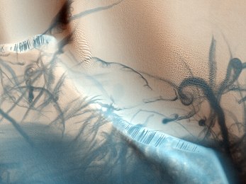
Martian Dust Devil Trails[edit]

- Reason
- High quality and mots interesting.
- Articles this image appears in
- Dust devil
- Creator
- NASA/JPL/University of Arizona
- Support as nominator --Noodle snacks (talk) 23:21, 28 November 2009 (UTC)
- Comment Very cool image but what is the blue/white band running thru the image? Doesn't seem to be mentioned in the image page caption. upstateNYer 01:16, 29 November 2009 (UTC)
- I'm not sure to be honest. If I had to guess it'd be reflections of sunlight. Noodle snacks (talk) 06:19, 29 November 2009 (UTC)
- Strong support. Magnificent and highly encyclopedic. Durova371 06:16, 29 November 2009 (UTC)
- Support I think this can make many read more. I will take the opportunity to also ask for more explanation from someone who managed to understand what we are seing. I read in the image description that the trails are the darkened paths but they dont look like like trails, they have the same texture as the light terrain but dark. I don't understand what I am seing. The light band is also a mistery to me. franklin.vp 19:54, 29 November 2009 (UTC)
- Oh, I understood now. They have a greyscale image (the original) and then they project that on a map. I think that explains why the trails also have the texture of the terrain although they are supposed to be trails of a dust devil. The white band is also there but is not so anoying in the greyscale image. Hopefully NASA knows their business. (which many times seems to be chock people or amaze them to justify or sell their research or games) franklin.vp 20:04, 29 November 2009 (UTC)
- Conditional support if someone can translate "Latitude (centered): 26.7 °. Longitude (East): 62.8 °. Range to target site: 284.9 km. Original image scale range: 57.0 cm/pixel (with 2 x 2 binning) so objects ~171 cm across are resolved. Map projected scale: 50 cm/pixel and north is up. Map projection: EQUIRECTANGULAR. Emission angle: 0.3 °. Phase angle: 51.3 °. Solar incidence angle: 51 °, with the Sun about 39 ° above the horizon. Solar longitude: 326.8 °, Northern Winter." into some appropriate language in the caption that explains the size of the area depicted in this photograph and of the features shown in it. Translating Martian longitude-latitude coordinates into kilometers is left as an exercise for the reader. Spikebrennan (talk) 16:17, 30 November 2009 (UTC)
- Support --JN466 12:46, 6 December 2009 (UTC)
- Support Mikael Häggström (talk) 15:44, 6 December 2009 (UTC)
Promoted File:Martian Dust Devil Trails.jpg --Caspian blue 03:11, 10 December 2009 (UTC)
