
Western station (CTA Blue Line Forest Park branch)
Western 2400W 430S | ||||||||||||||||||||||||||||||||||||||||||||||||||||||||||||||||||||||||||||||||||||
|---|---|---|---|---|---|---|---|---|---|---|---|---|---|---|---|---|---|---|---|---|---|---|---|---|---|---|---|---|---|---|---|---|---|---|---|---|---|---|---|---|---|---|---|---|---|---|---|---|---|---|---|---|---|---|---|---|---|---|---|---|---|---|---|---|---|---|---|---|---|---|---|---|---|---|---|---|---|---|---|---|---|---|---|---|
| Chicago 'L' rapid transit station | ||||||||||||||||||||||||||||||||||||||||||||||||||||||||||||||||||||||||||||||||||||
,_looking_east.jpg) | ||||||||||||||||||||||||||||||||||||||||||||||||||||||||||||||||||||||||||||||||||||
| General information | ||||||||||||||||||||||||||||||||||||||||||||||||||||||||||||||||||||||||||||||||||||
| Location | 430 South Western Avenue Chicago, Illinois 60612 | |||||||||||||||||||||||||||||||||||||||||||||||||||||||||||||||||||||||||||||||||||
| Coordinates | 41°52′32″N 87°41′18″W / 41.875478°N 87.688436°W | |||||||||||||||||||||||||||||||||||||||||||||||||||||||||||||||||||||||||||||||||||
| Owned by | Chicago Transit Authority | |||||||||||||||||||||||||||||||||||||||||||||||||||||||||||||||||||||||||||||||||||
| Line(s) | Forest Park Branch | |||||||||||||||||||||||||||||||||||||||||||||||||||||||||||||||||||||||||||||||||||
| Platforms | 1 island platform | |||||||||||||||||||||||||||||||||||||||||||||||||||||||||||||||||||||||||||||||||||
| Tracks | 2 | |||||||||||||||||||||||||||||||||||||||||||||||||||||||||||||||||||||||||||||||||||
| Construction | ||||||||||||||||||||||||||||||||||||||||||||||||||||||||||||||||||||||||||||||||||||
| Structure type | Expressway median | |||||||||||||||||||||||||||||||||||||||||||||||||||||||||||||||||||||||||||||||||||
| Bicycle facilities | Yes | |||||||||||||||||||||||||||||||||||||||||||||||||||||||||||||||||||||||||||||||||||
| History | ||||||||||||||||||||||||||||||||||||||||||||||||||||||||||||||||||||||||||||||||||||
| Opened | June 22, 1958 | |||||||||||||||||||||||||||||||||||||||||||||||||||||||||||||||||||||||||||||||||||
| Passengers | ||||||||||||||||||||||||||||||||||||||||||||||||||||||||||||||||||||||||||||||||||||
| 2022 | 237,176[1] | |||||||||||||||||||||||||||||||||||||||||||||||||||||||||||||||||||||||||||||||||||
| Services | ||||||||||||||||||||||||||||||||||||||||||||||||||||||||||||||||||||||||||||||||||||
| ||||||||||||||||||||||||||||||||||||||||||||||||||||||||||||||||||||||||||||||||||||
| ||||||||||||||||||||||||||||||||||||||||||||||||||||||||||||||||||||||||||||||||||||
| ||||||||||||||||||||||||||||||||||||||||||||||||||||||||||||||||||||||||||||||||||||
| Location | ||||||||||||||||||||||||||||||||||||||||||||||||||||||||||||||||||||||||||||||||||||
 | ||||||||||||||||||||||||||||||||||||||||||||||||||||||||||||||||||||||||||||||||||||
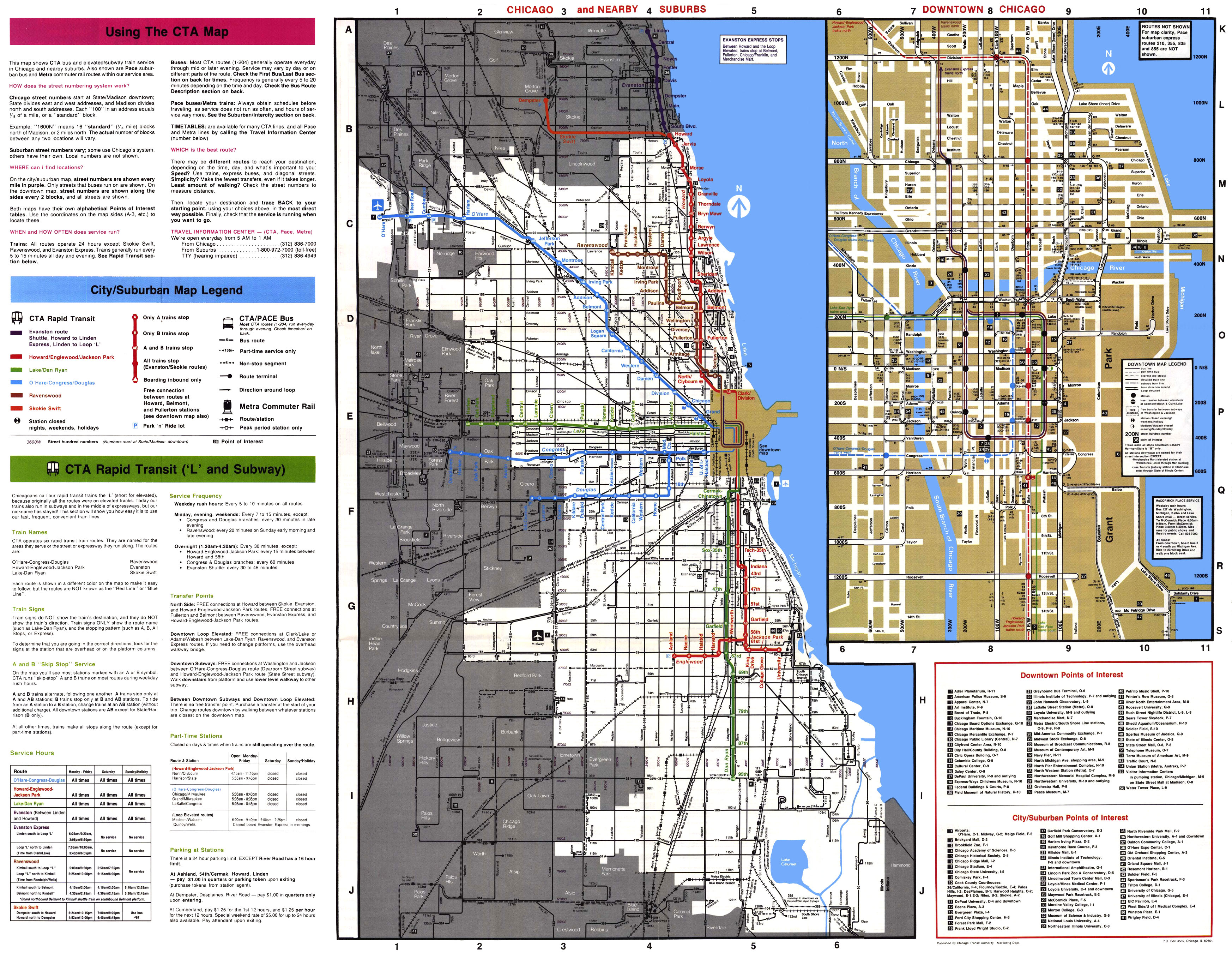
Western is a station on the 'L' system, serving the Blue Line's Forest Park branch. It is located in the median of the Eisenhower Expressway. It serves the Near West Side neighborhood and Crane Tech High School. The station is also located about 1 mile (1.6 km) north of the Western Avenue (Metra BNSF Railway Line) commuter railroad station.
History[edit]
Elevated station[edit]
The original Western station opened in 1895 along with numerous stations on the Metropolitan West Side Elevated lines. When skip-stop service was implemented on the Garfield Park branch in 1951, Western station was designated an A station (only A trains would stop at this station).[2] In 1953, the elevated station was closed in favor of temporary tracks running along Van Buren Street. The temporary tracks were built to accommodate the construction of the Congress Expressway and an expressway-median branch.[3]
Expressway-median station[edit]
The expressway-median station opened on June 22, 1958. During the time when the CTA utilized skip-stop services, the station was designated as an A station, much like its elevated predecessor. This time, however, all stations on the Congress branch west of Racine station were A stations; B trains would run along the Douglas branch (part of today's Pink Line).[4][5]
Bus connections[edit]
- 7 Harrison (Weekdays only)
- 49 Western (Owl Service)
- X49 Western Express (Weekday Rush Hours only)
References[edit]
- ^ "Annual Ridership Report – Calendar Year 2022" (PDF). Chicago Transit Authority, Ridership Analysis and Reporting. February 2, 2023. Retrieved June 10, 2023.
- ^ "CTA revises Garfield, Douglas, institutes A-B service". Chicago Tribune. 1 December 1951. p. 4. Retrieved 29 November 2023.
- ^ "Chicago L.org: Stations - Western". www.chicago-l.org. Retrieved 28 November 2023.
- ^ Chicago Transit Authority System Map (Map). Chicago Transit Authority. March 1991. Retrieved 29 November 2023.
- ^ "Chicago L.org: Stations - Western". www.chicago-l.org. Retrieved 28 November 2023.
External links[edit]
- Western (Congress Line) Station Page Chicago-L.Org
- Western Avenue entrance from Google Maps Street View
This Illinois train station-related article is a stub. You can help Wikipedia by expanding it. |