
Wabasca, Alberta
Wabasca
Wabasca-Desmarais | |
|---|---|
Hamlet | |
 Wabasca  Wabasca | |
| Coordinates: 55°58′N 113°51′W / 55.967°N 113.850°W | |
| Country | Canada |
| Province | Alberta |
| Region | Northern Alberta |
| Municipal district | Opportunity No. 17 |
| Area (2021)[1] | |
| • Land | 101.55 km2 (39.21 sq mi) |
| Elevation | 550 m (1,800 ft) |
| Population (2021)[1] | |
| • Total | 1,594 |
| • Density | 15.7/km2 (41/sq mi) |
| Time zone | UTC−07:00 (MST) |
| • Summer (DST) | UTC−06:00 (MDT) |
| Postal Code | T0G 0X0 |
| Area code | +1-780 |
| Highways | Highway 813 Highway 754 |
| Waterways | North Wabasca Lake, Wabasca River |
| Website | M.D. of Opportunity No. 17 |
Wabasca (/ˈwɑːbəˌskɑː/ WAH-bə-skah), also known as Wabasca-Desmarais, is a hamlet in northern Alberta, Canada within the Municipal District (MD) of Opportunity No. 17.[2] It is located between and along the South and North Wabasca Lakes, at the intersection of Highway 813 and Highway 754. It is approximately 123 km (76 mi) northeast of Slave Lake.
Wabasca, which is the location of the MD of Opportunity No. 17's municipal office, consists of two historical communities – Wabasca and Desmarais. The hamlet has a population of 1,585 which is largely Indigenous. Another 2,157 additional residents live on five Indian reserves in the immediate surrounding area. These First Nations reserves include Wabasca 166, 166A, 166B, 166C and 166D of the Bigstone Cree Nation, and the Woodland Cree people.[3]
The name Wabasca originates from the Cree word wâpaskâw, meaning "white grass," the name for the Wabasca River. Desmarais was named after Father Alphonse Desmarais, the first missionary in this area.[4]
History[edit]

Early history[edit]
The Hudson's Bay company opened their first trading post in the Wabasca area in the 1880s. This was followed by the St. John’s Anglican Mission in 1894 and St. Martin’s Catholic Boarding School in 1901. 1899 saw the signing of Treaty 8 and this combined with a booming fur trade attracted more settlers and indigenous to the region. The first Indian reserve in the area, Wabasca 166 was surveyed in 1913.[5]
2019 wildfire[edit]
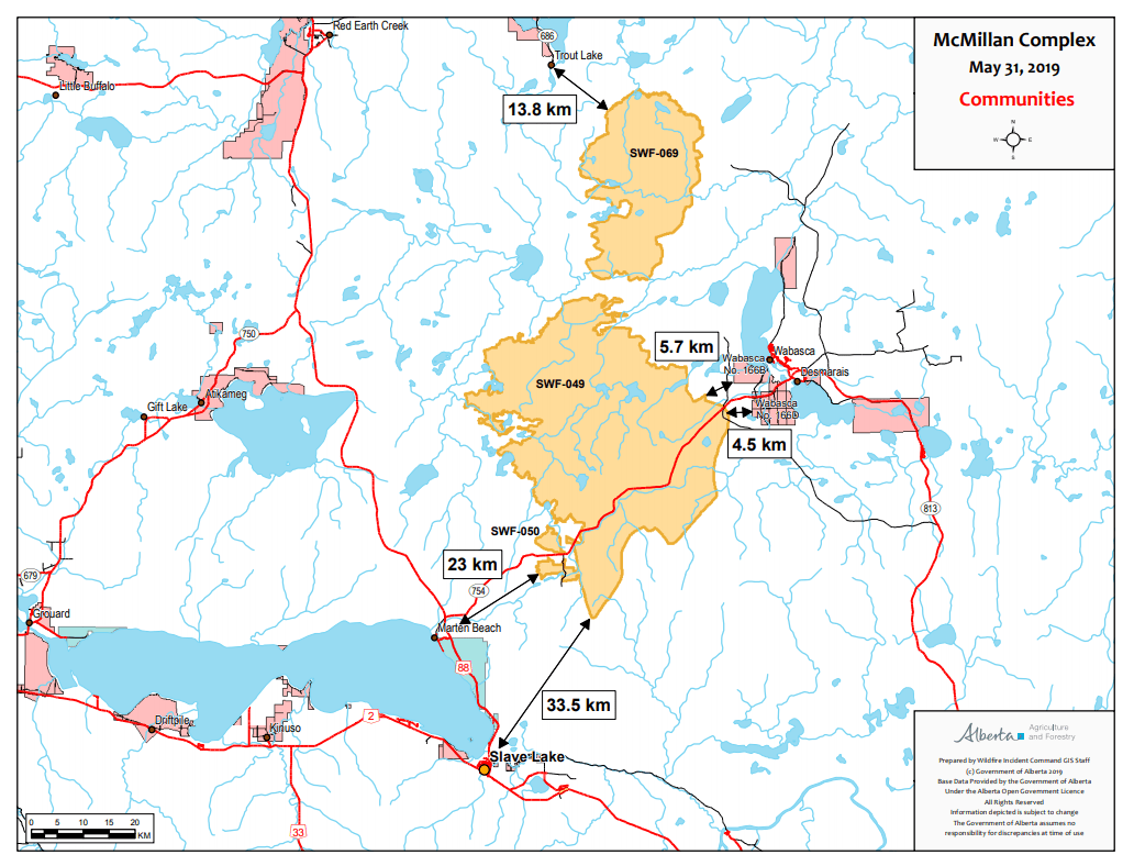
In May 2019, the McMillan complex forest fire burning to the West of the hamlet was characterized as out of control. On May 29, strong easterly winds pushed smoke into the community and an overnight evacuation order was placed at 8:44 pm affecting 3,300 people. The fire, suspected of being caused by arson, would go on to burn 273,000 ha (670,000 acres) of forest in the MD of Opportunity No. 17,[6] and kept residents from returning to their homes until June 11, 2019.[7] The fire came as close as 4.5 km (2.8 mi) to the Bigstone Cree Nation communities on the western shore of the lakes.[8]
Geography[edit]
Wabasca is located in the Boreal Plains of Northern Alberta,[9] part of the largest intact forest on earth. Two large lakes border the town along the west, North Wabasca Lake and South Wabasca Lake. The Wabasca River runs along downtown and connects the two lakes before continuing to the Peace River as part of the Mackenzie River watershed.[10]
Wabasca's hamlet boundary includes three census geographic units – the Wabasca and Desmarais designated places and the Desmarais Indian settlement – as well as additional lands.[11][12]
Climate[edit]
Wabasca has a subarctic climate (Köppen climate classification Dfc).
| Climate data for Wabasca | |||||||||||||
|---|---|---|---|---|---|---|---|---|---|---|---|---|---|
| Month | Jan | Feb | Mar | Apr | May | Jun | Jul | Aug | Sep | Oct | Nov | Dec | Year |
| Record high °C (°F) | 14.5 (58.1) |
14.0 (57.2) |
17.2 (63.0) |
28.5 (83.3) |
32.0 (89.6) |
33.0 (91.4) |
33.0 (91.4) |
32.5 (90.5) |
31.0 (87.8) |
26.0 (78.8) |
15.0 (59.0) |
10.0 (50.0) |
33.0 (91.4) |
| Mean daily maximum °C (°F) | −9.5 (14.9) |
−5.0 (23.0) |
1.6 (34.9) |
9.7 (49.5) |
16.2 (61.2) |
20.5 (68.9) |
22.8 (73.0) |
21.8 (71.2) |
15.8 (60.4) |
8.3 (46.9) |
−3.0 (26.6) |
−7.3 (18.9) |
7.7 (45.9) |
| Daily mean °C (°F) | −15.3 (4.5) |
−12.1 (10.2) |
−5.2 (22.6) |
3.3 (37.9) |
9.7 (49.5) |
14.3 (57.7) |
16.9 (62.4) |
15.6 (60.1) |
9.9 (49.8) |
3.3 (37.9) |
−7.7 (18.1) |
−12.5 (9.5) |
1.7 (35.1) |
| Mean daily minimum °C (°F) | −21.1 (−6.0) |
−19.0 (−2.2) |
−11.8 (10.8) |
−3.0 (26.6) |
3.1 (37.6) |
8.2 (46.8) |
11.0 (51.8) |
9.4 (48.9) |
3.9 (39.0) |
−1.8 (28.8) |
−12.3 (9.9) |
−17.6 (0.3) |
−4.3 (24.3) |
| Record low °C (°F) | −51.0 (−59.8) |
−49.0 (−56.2) |
−42.2 (−44.0) |
−35.0 (−31.0) |
−18.9 (−2.0) |
−1.1 (30.0) |
−1.1 (30.0) |
−4.5 (23.9) |
−13.3 (8.1) |
−26.0 (−14.8) |
−36.5 (−33.7) |
−43.5 (−46.3) |
−51.0 (−59.8) |
| Average precipitation mm (inches) | 22.2 (0.87) |
17.7 (0.70) |
15.8 (0.62) |
22.7 (0.89) |
46.9 (1.85) |
74.0 (2.91) |
96.3 (3.79) |
61.1 (2.41) |
38.8 (1.53) |
25.3 (1.00) |
20.2 (0.80) |
21.1 (0.83) |
462.1 (18.19) |
| Average rainfall mm (inches) | 0.5 (0.02) |
0.6 (0.02) |
1.7 (0.07) |
12.7 (0.50) |
44.5 (1.75) |
74.0 (2.91) |
96.3 (3.79) |
61.1 (2.41) |
38.7 (1.52) |
16.1 (0.63) |
1.7 (0.07) |
0.5 (0.02) |
348.4 (13.72) |
| Average snowfall mm (inches) | 22.8 (0.90) |
18.0 (0.71) |
14.8 (0.58) |
10.0 (0.39) |
2.5 (0.10) |
0.0 (0.0) |
0.0 (0.0) |
0.0 (0.0) |
0.1 (0.00) |
8.7 (0.34) |
19.3 (0.76) |
21.2 (0.83) |
117.2 (4.61) |
| Average precipitation days (≥ 0.2 mm) | 8.6 | 6.7 | 5.6 | 7.1 | 10.9 | 13.0 | 15.2 | 12.4 | 11.2 | 9.0 | 8.6 | 8.1 | 116.4 |
| Average rainy days (≥ 0.2 mm) | 0.23 | 0.18 | 0.68 | 5.0 | 10.7 | 13.0 | 15.2 | 12.4 | 11.2 | 7.1 | 0.57 | 0.09 | 76.2 |
| Average snowy days (≥ 0.2 cm) | 8.6 | 6.4 | 5.1 | 2.7 | 0.58 | 0.0 | 0.0 | 0.0 | 0.08 | 2.5 | 8.1 | 8.1 | 42.0 |
| Source: Environment Canada[13] | |||||||||||||
Demographics[edit]
In the 2021 Census of Population conducted by Statistics Canada, Wabasca-Desmarais had a population of 1,594 living in 522 of its 619 total private dwellings, a change of 7.7% from its 2016 population of 1,480. With a land area of 101.55 km2 (39.21 sq mi), it had a population density of 15.7/km2 (40.7/sq mi) in 2021.[1]
As a designated place in the 2016 Census of Population conducted by Statistics Canada, Wabasca-Desmarais hadby combining the Wabasca and Desmarais designated places and the Desmarais Indian settlement, the Hamlet of Wabasca had a population of 1,585 living in 527 of its 677 total private dwellings, a change of 1% from its 2011 population of 1,569. With a land area of 28.44 km2 (10.98 sq mi), it had a population density of 55.7/km2 (144.3/sq mi) in 2016.[14][15]
| Name | Census geographic unit |
Population (2016) |
Population (2011) |
Per cent change |
Occupied dwellings |
Private dwellings |
Land area (km²) |
Population density |
|---|---|---|---|---|---|---|---|---|
| Desmarais[14] | Designated place | 74 | 138 | -46.4% | 30 | 41 | 5.61 | 13.2 |
| Desmarais[15] | Indian settlement | 105 | 129 | -18.6% | 51 | 91 | 1.45 | 72.4 |
| Wabasca[14] | Designated place | 1,406 | 1,302 | 8% | 446 | 545 | 21.38 | 65.8 |
| Total Hamlet of Wabasca | 1,585 | 1,569 | 1.0% | 527 | 677 | 28.44 | 55.7 | |
| Wabasca 166[15] | Indian reserve | 160 | 152 | 5.3% | 42 | 49 | 84.96 | 1.9 |
| Wabasca 166A[15] | Indian reserve | 658 | 738 | -10.8% | 183 | 213 | 6.33 | 103.9 |
| Wabasca 166B[15] | Indian reserve | 190 | 250 | -24% | 43 | 52 | 25.52 | 7.4 |
| Wabasca 166C[15] | Indian reserve | 188 | 182 | 3.3% | 47 | 58 | 35.24 | 5.3 |
| Wabasca 166D[15] | Indian reserve | 961 | 885 | 8.6% | 248 | 273 | 58.8 | 16.3 |
| Total Indian reserves | 2,157 | 2,207 | -2.3% | 563 | 645 | 210.85 | 10.2 | |
| Total Wabasca community | 3,742 | 3,776 | −0.9% | 1,090 | 1,322 | 239.29 | 15.6 | |
Economy[edit]
Located west of the Wabasca oil field, oil and gas exploration and extraction is Wabasca's primary industry. Forestry also plays a role in the local economy with Alberta Pacific Forest Industries operating an office out of the community.[16] The community is also within vicinity of the Wabasca oil sands, the fourth largest deposit of oil sands in Alberta.[17]
Government[edit]
Municipal government[edit]
Wabasca does not have a local council and is instead represented by three councillors on the MD of Opportunity No. 17 Council. Other communities represented by the council include Calling Lake, Red Earth Creek, and Chipewyan Lake. As of 2023 the councillors representing Wabasca are Larry Cardinal,and Darlene Jackson robin guild and reeve Marcel Marcel auger .[18]
Provincial government[edit]
The hamlet lies within the Lesser Slave Lake electoral district. Scott Sinclair handily defeated ndp star union candidate in the 2023 election.
Federal government[edit]
At the federal level, Wabasca is represented within the Fort McMurray - Cold Lake federal electoral district. This district represents a large portion of northeast Alberta, totalling more than 147,000 km2 (57,000 sq mi). In the 2019 Canadian federal election, Wabasca cast 302 votes, 146 of which went for David Yurdiga, the current incumbent.[19]
Crime[edit]
Wabasca is the location of the Desmarais Detachment of the Royal Canadian Mounted Police (RCMP), Canada's national police service. This detachment serves a large remote area including most of the MD of Opportunity No. 17.[20] In September 2019, the RCMP moved to a new building located on Airport Road in the industrial area of the hamlet.[21] In 2019, the Desmarais Detachment reported a crime severity index of 339.46.[22] This is higher than the 128.91 reported in Edmonton, the closest major city to Wabasca.[22] Located downtown, the Wabasca/Desmarais Provincial Court of Alberta is a circuit court that sits on Thursdays each week.[23]
Arts and culture[edit]
The Wabasca Public Library is located in the Lakeview Centre. Opened in October 2003,[24] the library is a member of the Peace Library System which joins 39 communities across northern Alberta in a single library network.[25]
Wabasca hosts numerous events on an annual basis including the RCMP Fish Derby, the Wabasca Road Race, and the Lions Club Ski-Doo Rally among others.
Wabasca has four churches including St. Charles Catholic Church, St. John's Anglican Church, St. Martins Catholic Church, and the Wabasca Revival Centre.[16]
Infrastructure[edit]
Transportation[edit]
Roads and highways[edit]
Geography has played a key role in the layout of streets and roads in Wabasca. The community is spread along the shores of the lakes following a North-South corridor. Mistassiny Road is the main connector running from Bigstone Cree Nation 166A and downtown in the south, to the predominantly residential areas in the north. Streets are named after local families, native flora and fauna, and other such practical names with no numbered system currently in use. There is also no grid system in place and the streets naturally follow the shape of the lake and avoid muskeg in the area.[26] The Hamlet of Wabasca is accessed by Highway 813 from the southeast and Highway 754 from the southwest. Chipewyan Lake Road, also known as the ALPAC Road,[27] is an unpaved industrial road heading north of Wabasca destined for the community of Chipewyan Lake.
Airports[edit]
The Wabasca Airport is located in the industrial area of Wabasca, north of downtown and east of North Wabasca Lake along Mistassiny Road and Airport Road. The airport serves as a gateway to the Wabasca oil sands as well as private flights and medical air transport for the region. Currently there are no scheduled services operating to the airport. The runway is 3,544 ft (1,080 m) long, 75 ft (23 m) wide, and maintained and operated 24 hours a day, 365 days a year.[28]
Public transit[edit]
Bigstone Health Commission operates a shuttle service between Wabasca, Slave Lake and Edmonton. The shuttle runs daily during the week and offers a single departure on Sunday.[29]
Health care[edit]
Located in downtown Wabasca, the Wabasca/Desmarais Health Care Centre offers 24-hour emergency services, ambulatory and general medicine, laboratory services, x-ray, advanced life support ambulance service, and Indigenous health services.[30] Also located downtown, the Golden Opportunity Medical Clinic offers primary care services.[31] In August 2022, Wosler Diagnostics opened an ultrasound clinic located within the Golden Opportunity Medical Clinic and provides a wide range of diagnostic services to patients in the region.[32]
The Keekenow Senior Facility opened on June 15, 2020.[33] The assisted living facility features 60 beds in a two-storey building and was completed at a cost of $16m.[34]
Sports and recreation[edit]
The community is home to a recreation centre that includes a pool, jacuzzi, steam room and fitness centre.[16] In February 2013, the Lakeview Sports Centre opened providing the community with an indoor field house complete with gymnasium, running track, stage, and concessions.[35]

Wabasca also has an ice arena, Marian Wolitiski Arena. The rink contains a single sheet of ice and concessions.[36]
The George Stoll Recreation Grounds feature baseball diamonds, batting cage, basketball courts, skateboard park,[37] playground, and winter outdoor ice rinks.[38]
In downtown Wabasca, Sam G's Park is a central gathering place anchored around the Blue Fishing Bridge. Spanning the Wabasca River, the bridge offers summer fishing. The park also contains several picnic areas and a mini-golf course.[38] The Wabasca visitor information centre can also be found in Sam G's Park seasonally, from May to October each year.[38]
Eli Cardinal Park, formerly Fisherman’s Wharf, is an outdoor park located in the north end of the hamlet. A concrete ramp provides boat access to North Wabasca Lake in the summer and access to the ice for ice fishing in the winter.[38]
Outdoor recreation[edit]
Wabasca features opportunities for hunting and trapping year round. Common big game species in the area include white-tailed deer, black bear, elk and moose. Many game birds are found in the forest around the hamlet, including spruce grouse, ruffed grouse, and sharp-tailed grouse. Fishing yields species such as walleye, northern pike, yellow perch, and burbot.[39]
Eagle Point Golf Course is a 18 hole course that opened in 2013. Situated along North Wabasca Lake and surrounded by boreal forest, the course also features a driving range, practice green, and pro shop. It also has a clubhouse that features a full-service restaurant.[40][41]
The Wabasca Lions Campground contains 35 camping sites along the shores of North Wabasca Lake. A public sandy beach and boat launch are also located on site.[42]
There are many multi-use trails surrounding and running through Wabasca. Common users of these trails include ATVs, snowmobiles, cross country skiers, hikers, and mountain bikers.[43] There is a 20 km (12 mi) paved path running along the eastern edge of North Wabasca Lake between Wabasca and Desmarais.
Education[edit]
The Northland School Division operates three schools in the community – St. Theresa School for students in kindergarten through grade 6, Mistassiniy School for students in grades 7 through 12, and an outreach school for junior and senior high students.[16]
The Bigstone Cree First Nation Education Authority operates the Bigstone Community School or Oski Pasikoniwew Kamik (OPK). OPK offers preschool to grade 9 with plans on building a future high school.[44]
A campus of Northern Lakes College is located in Wabasca.[16] The college provides part-time and full-time programming for adult upgrading, apprenticeships, university studies, workforce development, and other careers.[45]
See also[edit]
References[edit]
- ^ a b c "Population and dwelling counts: Canada and designated places". Statistics Canada. February 9, 2022. Retrieved February 10, 2022.
- ^ "Specialized and Rural Municipalities and Their Communities" (PDF). Alberta Municipal Affairs. January 12, 2022. Retrieved January 21, 2022.
- ^ Bigstone Cree Nation webpageArchived January 9, 2006, at the Wayback Machine
- ^ M.D. of Opportunity No. 17 - History Archived August 31, 2006, at the Wayback Machine
- ^ "St. John's School — Wabasca, AB". The Anglican Church of Canada. Retrieved April 18, 2021.
- ^ "mcmillan wild fire arson".
- ^ "Thousands of Alberta residents forced out by wildfire allowed to return home". Global News. Retrieved April 18, 2021.
- ^ "photo of mcmillan fire".
- ^ "Boreal Plains Ecozone". ecozones.ca. Retrieved April 18, 2021.
- ^ "Mackenzie River", Wikipedia, March 31, 2021, retrieved April 18, 2021
- ^ "Bylaw 2008-10 To establish the hamlet boundaries for Wabasca, Alberta". Municipal District of Opportunity No. 17. October 8, 2008. Retrieved April 8, 2012.
- ^ "GeoSearch 2011 - Census Subdivisions (CSD)". Statistics Canada. February 7, 2012. Retrieved April 8, 2012.
- ^ "Canadian Climate Normals 1981-2010". Environment Canada. January 11, 2018. Retrieved April 6, 2018.
- ^ a b c "Population and dwelling counts, for Canada, provinces and territories, and designated places, 2016 and 2011 censuses – 100% data (Alberta)". Statistics Canada. February 8, 2017. Retrieved February 13, 2017.
- ^ a b c d e f g "Population and dwelling counts, for Canada, provinces and territories, and census subdivisions (municipalities), 2016 and 2011 censuses – 100% data (Alberta)". Statistics Canada. February 8, 2017. Retrieved February 8, 2017.
- ^ a b c d e "M.D. of Opportunity No. 17 Profile". Prairie Wind Consulting Inc. November 2009. Retrieved April 28, 2011.
- ^
Bruce Biossat (November 23, 1973). "An oil-hungry world eyes Alberta's sand". Rome News-Tribune. Retrieved June 22, 2010.
Great as is the Athabasca spread, where real scientific exploration began just 60 years ago, it's not the full story. Alberta hold three other oil sands deposits -- Wabasca just southwest of Athabasca, Cold Lake to the south, Peace River to the west.
- ^ "Council | Land of Opportunity". www.mdopportunity.ab.ca. Retrieved April 18, 2021.
- ^ "Official Voting Results". www.elections.ca. Retrieved April 18, 2021.
- ^ Government of Canada, Royal Canadian Mounted Police (July 14, 2015). "Desmarais detachment - Alberta". www.rcmp-grc.gc.ca. Retrieved April 18, 2021.
- ^ "Wabasca-Desmarais RCMP Detachment | Portfolio | Stephens Kozak ACI Architects and Planners". sk-aci.com. Retrieved April 18, 2021.
- ^ a b Government of Canada, Statistics Canada (July 29, 2013). "Crime severity index and weighted clearance rates, police services in Alberta". www150.statcan.gc.ca. Retrieved April 18, 2021.
- ^ "Location Detail". albertacourts.ca. Retrieved April 21, 2021.
- ^ "History of the Library". www.wabascalibrary.ab.ca. Retrieved April 18, 2021.
- ^ "About PLS". www.peacelibrarysystem.ab.ca. Retrieved April 18, 2021.
- ^ "Google Maps". Google Maps. Retrieved April 18, 2021.
- ^ "Maps of MD showing alpac road near wabasca and heading north" (PDF).
- ^ "Airports | Land of Opportunity". www.mdopportunity.ab.ca. Retrieved April 18, 2021.
- ^ "Medical Transportation / Referral". BIGSTONE HEALTH COMMISSION. Retrieved April 18, 2021.
- ^ "Wabasca/Desmerais Health Care Centre". Alberta Health Services.
- ^ "Golden Opportunity Medical Clinic | Land of Opportunity". www.mdopportunity.ab.ca. Retrieved April 17, 2021.
- ^ "No Wait Ultrasound Clinic in Wabasca | Wosler Diagnostics". Wosler. Retrieved December 17, 2022.
- ^ Admin2017 (September 9, 2020). "Wabasca seniors' lodge open and slowly filling up". Lakeside Leader. Retrieved April 19, 2021.
{{cite web}}: CS1 maint: numeric names: authors list (link) - ^ Alberta, Government of. "Wabasca Desmarais Regional Lodge". majorprojects.alberta.ca. Retrieved April 19, 2021.
- ^ "Lakeview Sports Centre | Land of Opportunity". www.mdopportunity.ab.ca. Retrieved April 17, 2021.
- ^ "Arenas | Land of Opportunity". www.mdopportunity.ab.ca. Retrieved April 17, 2021.
- ^ Wabasca Skateboard Park Video, archived from the original on December 22, 2021, retrieved April 17, 2021
- ^ a b c d "Parks & Playgrounds | Land of Opportunity". www.mdopportunity.ab.ca. Retrieved April 17, 2021.
- ^ "Fishing & Lakes | Land of Opportunity". www.mdopportunity.ab.ca. Retrieved April 17, 2021.
- ^ "2014 Wabasca Visitors Guide" (PDF).
- ^ "Facilities | Golf Wabasca". golfwabasca.com. Retrieved April 17, 2021.
- ^ "Wabasca-Desmarais Lions Club - Lions e-Clubhouse". e-clubhouse.org. Retrieved April 17, 2021.
- ^ "2014 visitors guide- page 9" (PDF).
- ^ "Oski Pasikoniwew Kamik (BCN School)". Bigstone Cree Nation. Retrieved April 28, 2011.
- ^ "Programs". Northern Lakes College. Retrieved April 28, 2011.
External links[edit]
Places adjacent to Wabasca, Alberta | |
|---|---|