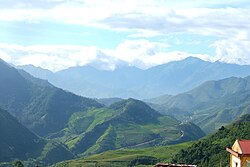
Trạm Tấu district
(Redirected from Trạm Tấu District)
You can help expand this article with text translated from the corresponding article in Vietnamese. (March 2009) Click [show] for important translation instructions.
|
Trạm Tấu District
Huyện Trạm Tấu | |
|---|---|
 | |
 Interactive map outlining Trạm Tấu District | |
| Country | |
| Region | Northeast |
| Province | Yên Bái |
| Capital | Trạm Tấu |
| Area | |
| • Total | 286 sq mi (742 km2) |
| Population (2003) | |
| • Total | 21,887 |
| Time zone | UTC+7 (UTC + 7) |
Trạm Tấu is a rural district of Yên Bái province, in the Northeast region of Vietnam. As of 2019, the district had a population of 33,962.[1] The district covers an area of 742 km². The district capital lies at Trạm Tấu.[1]
References[edit]
- ^ a b "Districts of Vietnam". Statoids. Retrieved March 23, 2009.
21°30′00″N 104°25′01″E / 21.500°N 104.417°E"City Populations of The TRẠM TẤU District"

