
Tollville, Arkansas
Tollville, Arkansas | |
|---|---|
 Tollville, Arkansas  Tollville, Arkansas | |
| Coordinates: 34°43′N 91°32′W / 34.717°N 91.533°W | |
| Country | United States |
| State | Arkansas |
| County | Prairie |
| Elevation | 213 ft (65 m) |
| Time zone | UTC-6 (Central (CST)) |
| • Summer (DST) | UTC-5 (CDT) |
| Area code | 870 |
| GNIS feature ID | 57211[1] |
Tollville is an unincorporated community east of Little Rock in Prairie County, Arkansas, United States. It was reportedly founded by the Toll family, who were English emigrants. Founding families also included the Claytons and the Foots. Lord Thomas Marsh Horsfall, a local Englishman and entrepreneur, owned much of this prairie ground in the late 1880s,[2] and many residents worshiped at an Episcopal Church (St. Peter's on the Prairie) that was erected in 1904.[3]
References[edit]
- ^ "US Board on Geographic Names". United States Geological Survey. October 25, 2007. Retrieved January 31, 2008.
- ^ Sickel, Marilyn Hambrick (February 14, 1995). "History of Prairie County". Ancestry.com. Retrieved August 14, 2009.
- ^ Protestant Episcopal Church (1905). Journal Proceedings of the 33rd Annual Council of the Diocese of Arkansas. Little Rock, Arkansas: Arkansas Democrat Company. p. 83. Retrieved August 14, 2009.
Municipalities and communities of Prairie County, Arkansas, United States | ||
|---|---|---|
| Cities | 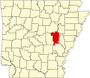 | |
| Towns | ||
| Unincorporated communities | ||
| Footnotes | ‡This populated place also has portions in an adjacent county of counties | |
This article about a location in Prairie County, Arkansas is a stub. You can help Wikipedia by expanding it. |