
Tochal
| Tochal | |
|---|---|
 Mount Tochal, located to the north of Tehran. | |
| Highest point | |
| Elevation | 3,963 m (13,002 ft)https://www.mountain-forecast.com/peaks/Tochal |
| Coordinates | ≈35°53′04″N 51°25′09″E / 35.88444°N 51.41917°E |
| Geography | |
 Tochal | |
| Parent range | Alborz |
Tochal (Persian: توچال Točāl), is a mountain and ski resort located on the Alborz mountain range, adjacent to the metropolitan area of Tehran in northern Iran. It includes a 12-kilometre-long (7.5 mi) ridge. Its highest peak, also called Tochal, is at an elevation of 3,963 metres (13,002 ft) above sea level.
A gondola lift runs from Tehran to the Tochal ski resort and hotel, all as a part of Tochal Complex.
Peaks[edit]
A number of peaks are accessible from the Tochal main ridge or by their own climbing paths. Peaks (from west to east) include:
- Lavarak (3,560 m [11,680 ft]): accessible by main Tochal ridge or Imamzade Davood climbing path.
- Bazarak (3,753 m [12,313 ft]): accessible by main Tochal ridge or Imamzade Davood climbing path.
- Palang-chal (3,520 m [11,550 ft]): accessible from Darakeh valley and Palangchal Shelter.
- Sar-Bazarak (3,640 m [11,940 ft]): accessible from Palangchal peak and main Tochal ridge.
- Shah-Neshin (3,875 m [12,713 ft]): accessible from Tochal main ridge, Hezarcham path and south (Abshar-Dogholoo) ridge.
- Tochal (3,964 m [13,005 ft]): The highest peak of the range, accessible by any climbing path that ends on the Tochal main ridge. The usual path from Tehran is by the south ridge (normally from Shirpala shelter and Siahsang hut).
- Spilit (3,120 m [10,240 ft]): through Band-yakh-chal and Shervin hut by rock climbing or Klakchal ridge.
- West Lezon (3,585 m [11,762 ft]): accessible from Tochal main ridge, Kolakchal shelter or Shirpala shelter.
- East Lezon or Piaz-chal (3,540 m [11,610 ft]): accessible from Tochal main ridge, Kolakchal shelter or Shirpala shelter.
- Kolak-chal (3,350 m [10,990 ft]): from Kolakchal shelter (through Golab-dareh valley, Vezbad valley or Jamshidieh park)
- Siah-band (3,320 m [10,890 ft]): from Dar-abad valley and Dar-abad hut.
Gondola lift[edit]


Tochal has a long gondola lift which begins from Velenjak valley at 1,900 m (6,200 ft) and ends in the last station at 3740m near the main ridge of Tochal. This gondola lift is used for accessing ski resorts and other recreational centers on the mountain.
Location in central Alborz[edit]
| Map of central Alborz | Peaks: | 1 Alam-Kuh |
|---|---|---|
 −25 to 500 m (−82 to 1,640 ft) 500 to 1,500 m (1,600 to 4,900 ft) 1,500 to 2,500 m (4,900 to 8,200 ft) 2,500 to 3,500 m (8,200 to 11,500 ft) 3,500 to 4,500 m (11,500 to 14,800 ft) 4,500 to 5,610 m (14,760 to 18,410 ft) |
2 Azad Kuh | 3 Damavand |
| 4 Do Berar | 5 Do Khaharan | |
| 6 Ghal'eh Gardan | 7 Gorg | |
| 8 Kholeno | 9 Mehr Chal | |
| 10 Mishineh Marg | 11 Naz | |
| 12 Shah Alborz | 13 Sialan | |
| 14 Tochal | 15 Varavašt | |
| Rivers: | 0 | |
| 1 Alamut | 2 Chalus | |
| 3 Do Hezar | 4 Haraz | |
| 5 Jajrood | 6 Karaj | |
| 7 Kojoor | 8 Lar | |
| 9 Noor | 10 Sardab | |
| 11 Seh Hazar | 12 Shahrood | |
| Cities: | 1 Amol | |
| 2 Chalus | 3 Karaj | |
| Other: | D Dizin | |
| E Emamzadeh Hashem | K Kandovan Tunnel | |
| * Latyan Dam | ** Lar Dam |
Opening Season[edit]
Tochal International Ski Resort, located in Iran’s capital Tehran, was officially reopened on 22.01.2024[1]
Pictures[edit]
-
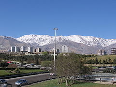
 Tochal Peak at 3,964 m (13,005 ft).
 -
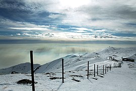
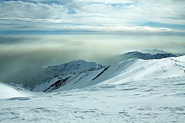
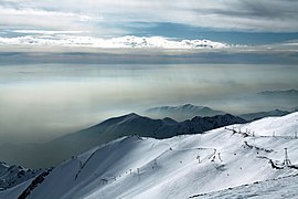
 Tochal mountains, Tehran, Iran.
 -
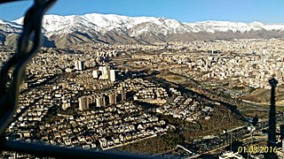 Milad Tower's view to the city and mountains.
 -
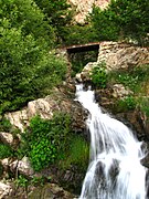 A scene in the vicinity of Shir-pala, Tochal.
 -
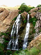 Darband Twin Falls, near Shir-pala, in Tochal main route.
 -
-
-

-

-
-

-

-


See also[edit]
References[edit]
- ^ "Tochal Ski Resort reopened". en.irna.ir. Retrieved 2024-01-22.