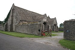
Tithe Barn, Manor Farm, Doulting
| Tithe Barn, Manor Farm | |
|---|---|
 | |
| General information | |
| Town or city | Doulting |
| Country | England |
| Coordinates | 51°11′07″N 2°30′20″W / 51.1854°N 2.5056°W |
| Completed | 15th century |
The Tithe Barn at Manor Farm (also known as Abbey Barn) in Doulting, Somerset, England, was built in the 15th century, and has been designated as a Grade I listed building,[1][2] and scheduled as an ancient monument.[3]
Tithe barns were used to store tithes, from the local farmers to the ecclesiastical landlords. In this case the landlord was Glastonbury Abbey.[4] A tithe (from Old English teogoþa "tenth") is a one-tenth part of something, paid as a (usually) voluntary contribution or as a tax or levy, usually to support a Christian religious organization.
The stone barn has eight bays supported by buttresses and two wagon porches.[4][3] The cruck roof trusses, at both ends of the barn, have timbers which have been shown by dendrochronology to have been felled between 1288 and 1290.[5][6] There are some curved windbraces.[2]
The stonework is showing signs water damage and erosion at the base of the walls.[7]
See also[edit]
References[edit]
- ^ Historic England. "Tithe Barn in farmyard at Manor Farm (1221353)". National Heritage List for England. Retrieved 17 March 2008.
- ^ a b Historic England. "Tithe Barn in farmyard at Manor Farm (1221353)". National Heritage List for England. Retrieved 1 October 2016.
- ^ a b Historic England. "The tithe barn (1003025)". National Heritage List for England. Retrieved 1 October 2016.
- ^ a b "Doulting Manor Barn". Great Barns. Retrieved 1 October 2016.
- ^ "Somerset" (PDF). Vernacular Architecture Group. Retrieved 1 October 2016.
- ^ "Somerset". Dendochronology.net. Retrieved 1 October 2016.
- ^ "Doulting Conservation Area Appraisal". Mendip Council. p. 22. Retrieved 1 October 2016.

