
Tarangnan
Tarangnan | |
|---|---|
| Municipality of Tarangnan | |
 Mountain-top view of Tarangnan | |
 Flag  Seal | |
 Map of Samar with Tarangnan highlighted | |
OpenStreetMap  | |
.svg) Tarangnan Location within the Philippines | |
| Coordinates: 11°54′N 124°45′E / 11.9°N 124.75°E | |
| Country | Philippines |
| Region | Eastern Visayas |
| Province | Samar |
| District | 1st district |
| Founded | April 1, 1884 |
| Barangays | 41 (see Barangays) |
| Government | |
| • Type | Sangguniang Bayan |
| • Mayor | Danilo V. Tan |
| • Vice Mayor | Arnel R. Tan |
| • Representative | Stephen James Tan |
| • Electorate | 19,761 voters (2022) |
| Area | |
| • Total | 132.49 km2 (51.15 sq mi) |
| Elevation | 16 m (52 ft) |
| Highest elevation | 335 m (1,099 ft) |
| Lowest elevation | 0 m (0 ft) |
| Population (2020 census)[3] | |
| • Total | 25,713 |
| • Density | 190/km2 (500/sq mi) |
| • Households | 5,936 |
| Economy | |
| • Income class | 4th municipal income class |
| • Poverty incidence | 29.87 |
| • Revenue | ₱ 132.2 million (2020) |
| • Assets | ₱ 294.2 million (2020) |
| • Expenditure | ₱ 118 million (2020) |
| • Liabilities | ₱ 61.43 million (2020) |
| Service provider | |
| • Electricity | Samar 1 Electric Cooperative (SAMELCO 1) |
| Time zone | UTC+8 (PST) |
| ZIP code | 6704 |
| PSGC | |
| IDD : area code | +63 (0)55 |
| Native languages | Waray Tagalog |
Tarangnan, officially the Municipality of Tarangnan (Waray: Bungto han Tarangnan; Tagalog: Bayan ng Tarangnan), is a 4th class municipality in the province of Samar, Philippines. According to the 2020 census, it has a population of 25,713 people.[3]
Tarangnan is situated on the western coast of Samar Island, to the south-east of the ancient town of Bangahon (now Gandara) and to the north of Samar's capital Catbalogan. Tarangnan is found near the former ancient pueblo Tinago, the first town to be Christianized and was made a center or cabecera.[5]
Tarangnan has its own municipal hospital which was inaugurated in 1982, with a 10-bed capacity. It is augmented by Rural Health Unit extension workers. It has daycare centers which also cater the needs of pre-schoolers.
History[edit]
During the earlier part of the 17th century, Tarangnan or Tinago was the first settlement of Jesuit missionaries on the island of Samar. Tinago was the first cabecera on Samar where the first Jesuits have arrived, that is October 15, 1596. When Tinago was devastated by the Moro attack in 1616, the Jesuits decided to transfer the cabecera to Catbalogan. Since that time Tinago had not came back to life as pueblo until 1725.[6] The poblacion was established at Dapdap but for access and sanitation it was moved to tarangnan in 1883–1884.[7]
The attempted transfer of the pueblo from Dapdap to Tarangnan in 1882 became highly celebrated case. It was a struggle or a fight between the parish priest of Dapdap, fr. Angel Pulido, OFM and the governadorcillo of Dapdap.[8]

The town of Dapdap was transferred in 1884 to a barrio called Tarangnan, from which it derived its name today. At first the church and convento were constructed of light materials which means bamboo and nipa. The new church was constructed in 1894 by P. Venancio Palencia, OFM and completed in 1897.[9]
In the second half of the nineteenth century, the island of Samar experienced a commercial boom, especially in abaca, with imports and exports of abaca products. Moro raids in the island declined due to the presence of Spaniards. As the Spaniards settled in Samar, they saw the need of all-weather seaports and easy communications for their commercial activities and political administration. This development paved the way for the convergence of the inhabitants into the old town site of Tarangnan, where transport was relatively accessible. The settlement of Tarangnan was growing at a much faster pace than the pueblo of Dapdap.
Taking into consideration the island's commercial boom, with prospects of Tarangnan as a trading center and its religious vigilance over Dapdap, on June 21, 1881, Gov. Enrique Chacon wrote to his superiors. He recommended the transfer of the Poblacion from Dapdap to Tarangnan due to the former's poor accessibility, unavailability of land area for expansion, and its unsanitary environment.
On April 1, 1884, Tarangnan was declared as one of the municipalities of the Province of Samar by means of Royal Decree by the King of Spain, King Alfonso I.[citation needed]
In 1957, the following sitios were declared barrios: Cabunga-an,[10] Tigdaranao,[11] and Binalayan.[12]
In 1979, by virtue of Batas Pambansa Blg. 16, nine barangays were separated to create the municipality of Pagsanghan.[13]
Geography[edit]
The municipality of Tarangnan is geographically situated in the west portion of the island of Samar, bounded on the north by the municipality of Pagsanghan, in the south by the capital city of Catbalogan and on the west by the Samar Sea or Maqueda Bay. The distance of the poblacion to Catbalogan is about 36 kilometres (22 mi) and 60 kilometres (37 mi) away from Calbayog. It can be reached via an 11 kilometres (6.8 mi) road from the Maharlika Highway crossing Barangay Balugo by a provincial road.
Barangays[edit]
Tarangnan is politically subdivided into 41 barangays. Each barangay consists of puroks and some have sitios.
- Alcazar
- Awang
- Bahay
- Balonga-as
- Balugo
- Bangon Gote
- Baras
- Binalayan
- Bisitahan
- Bonga
- Cabunga-an
- Cagtutulo
- Cambatutay Nuevo
- Cambatutay Viejo
- Canunghan
- Catan-agan
- Dapdap
- Gallego
- Imelda Pob. (Posgo)
- Lucerdoni (Irong-irong)
- Lahong
- Libucan Dacu
- Libucan Gote
- Majacob
- Mancares
- Marabut
- Oeste - A
- Oeste - B
- Pajo
- Palencia
- Poblacion A
- Poblacion B
- Poblacion C
- Poblacion D
- Poblacion E
- San Vicente
- Santa Cruz
- Sugod
- Talinga
- Tigdaranao
- Tizon
Climate[edit]
| Climate data for Tarangnan, Samar | |||||||||||||
|---|---|---|---|---|---|---|---|---|---|---|---|---|---|
| Month | Jan | Feb | Mar | Apr | May | Jun | Jul | Aug | Sep | Oct | Nov | Dec | Year |
| Mean daily maximum °C (°F) | 28 (82) |
29 (84) |
29 (84) |
31 (88) |
31 (88) |
30 (86) |
29 (84) |
29 (84) |
29 (84) |
29 (84) |
29 (84) |
28 (82) |
29 (85) |
| Mean daily minimum °C (°F) | 21 (70) |
21 (70) |
21 (70) |
22 (72) |
24 (75) |
24 (75) |
24 (75) |
25 (77) |
24 (75) |
24 (75) |
23 (73) |
22 (72) |
23 (73) |
| Average precipitation mm (inches) | 72 (2.8) |
52 (2.0) |
65 (2.6) |
62 (2.4) |
87 (3.4) |
129 (5.1) |
153 (6.0) |
124 (4.9) |
147 (5.8) |
157 (6.2) |
139 (5.5) |
117 (4.6) |
1,304 (51.3) |
| Average rainy days | 17.4 | 13.4 | 16.8 | 18.0 | 22.0 | 25.3 | 26.2 | 24.2 | 24.9 | 26.0 | 23.3 | 20.8 | 258.3 |
| Source: Meteoblue[14] | |||||||||||||
Demographics[edit]
| Year | Pop. | ±% p.a. |
|---|---|---|
| 1903 | 6,184 | — |
| 1918 | 7,286 | +1.10% |
| 1939 | 11,605 | +2.24% |
| 1948 | 12,271 | +0.62% |
| 1960 | 15,984 | +2.23% |
| 1970 | 17,551 | +0.94% |
| 1975 | 19,489 | +2.12% |
| 1980 | 15,558 | −4.40% |
| 1990 | 15,894 | +0.21% |
| 1995 | 18,791 | +3.19% |
| 2000 | 20,538 | +1.92% |
| 2007 | 22,767 | +1.43% |
| 2010 | 24,146 | +2.16% |
| 2015 | 24,992 | +0.66% |
| 2020 | 25,713 | +0.56% |
| Source: Philippine Statistics Authority [15][16][17][18] | ||
Economy[edit]
Graphs are unavailable due to technical issues. There is more info on Phabricator and on MediaWiki.org. |
Education[edit]
Some years back, Tarangnan was estimated to have a low literacy rate. But, with the opening of primary education in some barangays and expansion of secondary education (Tarangnan National High School) in Barangay Oeste, its literacy rose dramatically to 89.95%, as recorded in the NSO 1995 survey.
- Tarangnan National High School
- Oeste National High School
- Tizon National High School
- Majacob Integrated School
Gallery[edit]
-
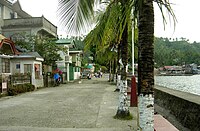
 Entering Tarangnan Town Proper
 -
 Going To Pantalan (Wharf)
 -
 Town Hall
 -
 High School
 -
 Sea Side
 -
 Panapukan Beach (one of the beaches)


Notes[edit]
- ^ Municipality of Tarangnan | (DILG)
- ^ "2015 Census of Population, Report No. 3 – Population, Land Area, and Population Density" (PDF). Philippine Statistics Authority. Quezon City, Philippines. August 2016. ISSN 0117-1453. Archived (PDF) from the original on May 25, 2021. Retrieved July 16, 2021.
- ^ a b Census of Population (2020). "Region VIII (Eastern Visayas)". Total Population by Province, City, Municipality and Barangay. Philippine Statistics Authority. Retrieved 8 July 2021.
- ^ "PSA Releases the 2018 Municipal and City Level Poverty Estimates". Philippine Statistics Authority. 15 December 2021. Retrieved 22 January 2022.
- ^ Kobak, Cantius (2002). Historical Sketches of the Pueblos of Samar and Leyte: 1580-1900. Milwaukee, Wisconsin: Unpublished. p. 721 - 723.
- ^ ARSI, Catalogi, Phil. 4. fol. 127, Central Archives of Rome
- ^ Cruikshank, Robert Bruce (1975). A History of Samar Island, 1768 - 1898. pp. 271.
- ^ Cruikshank: pp. 169 - 186
- ^ Martin y Morales, Ensayo de una sintesis de los trabajos realizados por las corporaciones religiosas espanolas de Filipinas 1901 p. 493,
- ^ "An Act to Convert the Sitio of Cabunga-an in the Municipality of Tarangnan, Province of Samar, into a Regular Barrio". LawPH.com. Retrieved 2011-04-12.
- ^ "An Act to Convert the Sitio of Tigdaranao in the Municipality of Tarangnan, Province of Samar, into a Regular Barrio". LawPH.com. Retrieved 2011-04-13.
- ^ "An Act to Convert the Sitio of Binalayan in the Municipality of Tarangnan, Province of Samar, into a Regular Barrio". LawPH.com. Retrieved 2011-04-13.
- ^ "Batas Pambansa Blg. 16". The LawPhil Project. Arellano Law Foundation. February 9, 1979. Retrieved March 22, 2023.
- ^ "Tarangnan: Average Temperatures and Rainfall". Meteoblue. Retrieved 29 February 2020.
- ^ Census of Population (2015). "Region VIII (Eastern Visayas)". Total Population by Province, City, Municipality and Barangay. Philippine Statistics Authority. Retrieved 20 June 2016.
- ^ Census of Population and Housing (2010). "Region VIII (Eastern Visayas)" (PDF). Total Population by Province, City, Municipality and Barangay. National Statistics Office. Retrieved 29 June 2016.
- ^ Censuses of Population (1903–2007). "Region VIII (Eastern Visayas)". Table 1. Population Enumerated in Various Censuses by Province/Highly Urbanized City: 1903 to 2007. National Statistics Office.
{{cite encyclopedia}}: CS1 maint: numeric names: authors list (link) - ^ "Province of Samar (Western Samar)". Municipality Population Data. Local Water Utilities Administration Research Division. Retrieved 17 December 2016.
- ^ "Poverty incidence (PI):". Philippine Statistics Authority. Retrieved December 28, 2020.
- ^ "Estimation of Local Poverty in the Philippines" (PDF). Philippine Statistics Authority. 29 November 2005.
- ^ "2003 City and Municipal Level Poverty Estimates" (PDF). Philippine Statistics Authority. 23 March 2009.
- ^ "City and Municipal Level Poverty Estimates; 2006 and 2009" (PDF). Philippine Statistics Authority. 3 August 2012.
- ^ "2012 Municipal and City Level Poverty Estimates" (PDF). Philippine Statistics Authority. 31 May 2016.
- ^ "Municipal and City Level Small Area Poverty Estimates; 2009, 2012 and 2015". Philippine Statistics Authority. 10 July 2019.
- ^ "PSA Releases the 2018 Municipal and City Level Poverty Estimates". Philippine Statistics Authority. 15 December 2021. Retrieved 22 January 2022.
External links[edit]
- Tarangnan Profile at PhilAtlas.com
- Philippine Standard Geographic Code
- Philippine Census Information
- Local Governance Performance Management System
Places adjacent to Tarangnan | ||||||||||||||||
|---|---|---|---|---|---|---|---|---|---|---|---|---|---|---|---|---|
| ||||||||||||||||
| Municipalities | |
|---|---|
| Component cities | |