
Ölfus
Sveitarfélagið Ölfus | |
|---|---|
 Wooden church Kotstrandarkirkja | |
 Location of the municipality | |
| Country | Iceland |
| Region | Southern Region |
| Constituency | South Constituency |
| Government | |
| • Mayor | Elliði Vignisson |
| Area | |
| • Total | 737 km2 (285 sq mi) |
| Population | |
| • Total | 1,906 |
| • Density | 2.59/km2 (6.7/sq mi) |
| Postal code(s) | 815, 816 |
| Municipal number | 8717 |
| Website | olfus |
Ölfus (Icelandic pronunciation: [ˈœlvʏs] ⓘ) is a municipality located in Iceland. The major town is called Þorlákshöfn. The bottled water brand Icelandic Glacial is manufactured in this area, at the Ölfus spring.
Geography[edit]
In Ölfus several lava tubes can be visited. Raufarhólshellir [ˈrœyːvarˌhoulsˌhɛtlɪr̥] is one of the longest lava tubes in Iceland with a length of 1360 metres and a height of up to 10 metres.[1] One of the most famous caves is Búri (cave). Another local cave is Arnarker [ˈa(r)tnarˌcʰɛːr̥] with a length of 516 metres.[2] Leitarhraun [ˈleiːtar̥ˌr̥œyːn] is a lava field which is about 5000 years old in the northwest of the municipality.[3] Lake Hlíðarvatn [ˈl̥iːðarˌvahtn̥] covering an area of 3,3 km2 is a lake with a depth of up to 5 metres which is known for its birdlife.[4] In Reykjadalur [ˈreiːcaˌtaːlʏr̥] valley several hot wells and springs are visited for bathing.[5] Árnarhellir [ˈau(r)tnarˌhɛtlɪr̥] is a stalactite cave near Þorlákshöfn.[6]
Earthquakes caused some damage in Ölfus in 1706 and 1896.[7]
Culture and sights[edit]
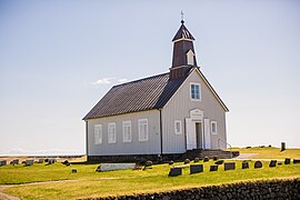
One of the most famous buildings in Ölfus is Strandarkirkja, a wooden church built in 1888 and renovated in 1968 and 1996 which has been mentioned in many old documents and stories.[8] Its retable was painted in 1865 by Sigurður Guðmundsson (1833–1874), the Icelandic painter, and the pulpit as well as the altar date from 1888.[9] Selvogsviti [ˈsɛlˌvɔksˌvɪːtɪ] is a lighthouse at Selvogur Bay measuring 20 metres in height which was built in 1991.[10] Close to the bay Fornigarður [ˈfɔ(r)tnɪˌkarðʏr̥] can be seen, an old wall measuring seven kilometres in length which in 1275 was mentioned in a document for the first time.[11] Sometimes it is called Langigarður [ˈlauɲcɪˌkarðʏr̥] or Strandargarður [ˈstrantarˌkarðʏr̥] as well. Originally its height amounted to 1.66 metres and its broadth to 0.96 centimetres, but due to erosion the wall has become lower and thinner.[12] Under its basis ash was found from a volcanic eruption of Hekla which took place in 1104. This could mean that the wall was built after 1104.
Hjallakirkja [ˈçatlaˌcʰɪr̥ca] is a Protestant church in the community of Hjalli [ˈçatlɪ] which was built in 1928. It houses various pieces of art, e.g. a pulpit dating from 1797 erbaut and a retable representing the resurrection of Christ.[13] Legend has it that the church was founded immediately after the introduction of Christianity in 1000, and according to Flóamanna saga the church was built by a settler called Skaftur Þóroddsson.[14]
Kotstrandarkirkja [ˈkʰɔtˌstrantarˌcʰɪr̥ca] is a comparatively large wooden church dating from 1909 with a well-kept garden in the community Kotströnd [ˈkʰɔtˌstrœnt]. Originally it served as a parish church for the neighbouring town of Hveragerði as well until Hveragerði got its own church.[15] The church is known for its bells dating from 1644 and for its retable painted by Örlygur Sigurðsson in 1878 which represents Jesus together with St. Peter, John and Jacob.[16] Kotströnd is a small community on highway no. 1. (Hringvegur) in the northeast of Ölfus.
Kögunarhóll is a hill measuring 61 metres in height close the main road no. 1 in the northeast of Ölfus which offers views of the area. As many traffic accidents happen there a memorial consisting of 52 crosses was erected in 2006 to remind on the victims.[17]
Infrastructure[edit]
Þorlákshöfn has a hotel, a camping area, a golf course, various restaurants and a sports centre with a public swimming pool. The townhall of the municipality of Ölfus (Ráðhús Ölfuss) is in Þorlákshöfn. There are various shops, a supermarket, primary school, kindergarten, public library, health care centre (Heilsugaelustöð), pharmacy, a gas station and repairing station as well.
-
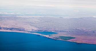 Aerial view of Ölfus with Reykjavík in the background
 -
 Typical landscape in Ölfus
 -
 Memorial in front of Kögunarhóll
 -
 Strandarkirkja
 -
 Strandarkirkja

.jpg)


References[edit]
- ^ "Raufarhólshellir".
- ^ "Arnarker".
- ^ "Leitarhraun".
- ^ "Hlíðarvatn".
- ^ "Áhugaverðir staðir".
- ^ "Árnahellir".
- ^ "Arnarbæli".
- ^ "Strandarkirkja - NAT ferðavísir". 21 July 2020.
- ^ "Strandarkirkja – sagan – Ferlir".
- ^ "Selvogur og Strandarkirkja".
- ^ "Djúpudalaborg – Ferlir".
- ^ "Fornigarður – Ferlir".
- ^ "Hjallakirkja".
- ^ "Hjallakirkja í Ölfusi". www.kirkjukort.net. Archived from the original on 7 May 2021. Retrieved 19 April 2022.
- ^ "Kotströnd".
- ^ "Kotstrandarkirkja". www.kirkjukort.net. Archived from the original on 9 December 2019. Retrieved 19 April 2022.
- ^ "Kögunarhóll – Inghóll – Ferlir".
| International | |
|---|---|
| National | |