
Steinsdalsfossen
| Steinsdalsfossen | |
|---|---|
 Steinsdalsfossen is visited by 300,000 tourists each year | |
  | |
 | |
| Location | Vestland, Norway |
| Coordinates | 60°22′14″N 06°06′10″E / 60.37056°N 6.10278°E |
| Elevation | 51 metres (167 ft) |
| Total height | 46 metres (151 ft) |
| Longest drop | 20 metres (66 ft) |
Steinsdalsfossen (also called Øvsthusfossen or Øfsthusfossen) is a waterfall in the village of Steine in the municipality of Kvam in Vestland county, Norway. The waterfall is located about 2 kilometres (1.2 mi) west of the large village of Norheimsund which sits along the Hardangerfjorden.[1]
The waterfall is one of the most visited tourist sites in Norway. From the parking lot, the path goes along the waterfall, up a hill, and behind it where visitors can walk dryshod "into" the rumbling water. Steinsdalsfossen is 46 metres (151 ft) high,[2] with a main drop of 20 metres (66 ft),[3] and has the greatest volume when the snow melts in May and June. Steinsdalsfossen is part of the Fosselva river that comes from the water of the lake Myklavatnet, located 814 metres (2,671 ft) above sea level in the mountains above the waterfall.[1]
History[edit]
The waterfall was formed in 1699 when the river found a new race.[4]
The Emperor Wilhelm II of Germany visited Steinsdalsfossen every summer (apart from two years) from 1889 until the start of World War I in 1914.
At Expo 2000 (in Hannover, Germany) Norway was represented with an installation by Marianne Heske of which a 15-metre (49 ft) tall copy of Steinsdalsfossen was an important part.
-
 In the fall
 -
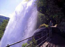 The path behind. (Photo: Willy Haraldsen)


See also[edit]
References[edit]
- ^ a b Store norske leksikon. "Fosselva" (in Norwegian). Retrieved 2014-06-29.
- ^ "Steinsdalsfossen – Top Waterfalls in the World". World Top Top. Retrieved 2013-11-10.
- ^ "Steinsdalsfossen". Veroldin. Retrieved 2013-11-10.
- ^ Natur Historisk Vegbok (2004) page 488, also 'Ættarbok for Kvam.'
External links[edit]
- A visit to Steinsdalsfossen
 Media related to Steinsdalsfossen at Wikimedia Commons
This Vestland location article is a stub. You can help Wikipedia by expanding it. |