
Sparta, North Carolina
Sparta, North Carolina | |
|---|---|
 Aerial view of Sparta | |
 Seal | |
 | |
| Coordinates: 36°30′12″N 81°07′18″W / 36.50333°N 81.12167°W | |
| Country | United States |
| State | North Carolina |
| County | Alleghany |
| Named for | Sparta, the Greek city-state |
| Government | |
| • Mayor | Wes Brinegar |
| Area | |
| • Total | 2.36 sq mi (6.11 km2) |
| • Land | 2.35 sq mi (6.08 km2) |
| • Water | 0.01 sq mi (0.02 km2) |
| Elevation | 2,861 ft (872 m) |
| Population (2020) | |
| • Total | 1,834 |
| • Density | 780.76/sq mi (301.47/km2) |
| Time zone | UTC-5 (Eastern (EST)) |
| • Summer (DST) | UTC-4 (EDT) |
| ZIP code | 28675 |
| Area code | 336 |
| FIPS code | 37-63680[3] |
| GNIS feature ID | 2407378[2] |
| Website | www |
Sparta is a town in Alleghany County, North Carolina, United States. As of the 2020 census, the population of the town was 1,834.[4] It is the county seat of Alleghany County.[5]
History[edit]
James H. Parks, an early businessman whose store stood near the present location of the ABC store, was one of three men who donated land for the county seat in 1866. Parks is credited with suggesting the name "Sparta", after the Greek city-state.
Noteworthy businesses established in Sparta included The Alleghany News (1889), the Bank of Sparta (1902), and the second store purchased by home improvement giant Lowe's (1949). Sparta's first shopping center, Trojan Village, opened in 1977, followed by Sparta Plaza in 1986.[6]
The Alleghany County Courthouse and Jarvis House are listed on the National Register of Historic Places.[7]
On August 9, 2020, the town was the epicenter of a moderate earthquake that was felt as far as Georgia.[8] The earthquake, which registered as a 5.1 on the Richter magnitude scale, was the largest earthquake to occur in North Carolina in over 100 years.[9]
Geography[edit]
According to the United States Census Bureau, the town has a total area of 2.4 square miles (6.2 km2), of which 0.0077 square miles (0.02 km2), or 0.32%, is water.[10]
Climate[edit]
| Climate data for SPARTA 3.5 SSW, NC, 1991-2020 normals | |||||||||||||
|---|---|---|---|---|---|---|---|---|---|---|---|---|---|
| Month | Jan | Feb | Mar | Apr | May | Jun | Jul | Aug | Sep | Oct | Nov | Dec | Year |
| Mean daily maximum °F (°C) | 44.5 (6.9) |
46.4 (8.0) |
52.8 (11.6) |
63.4 (17.4) |
70.6 (21.4) |
79.8 (26.6) |
83.6 (28.7) |
82.1 (27.8) |
75.0 (23.9) |
65.8 (18.8) |
54.8 (12.7) |
46.2 (7.9) |
63.8 (17.7) |
| Daily mean °F (°C) | 33.4 (0.8) |
35.4 (1.9) |
42.1 (5.6) |
51.6 (10.9) |
59.9 (15.5) |
68.5 (20.3) |
72.7 (22.6) |
70.9 (21.6) |
63.9 (17.7) |
53.5 (11.9) |
43.4 (6.3) |
36.0 (2.2) |
52.6 (11.4) |
| Mean daily minimum °F (°C) | 22.3 (−5.4) |
24.4 (−4.2) |
31.3 (−0.4) |
39.8 (4.3) |
49.2 (9.6) |
57.1 (13.9) |
61.7 (16.5) |
59.6 (15.3) |
52.7 (11.5) |
41.2 (5.1) |
31.9 (−0.1) |
25.8 (−3.4) |
41.4 (5.2) |
| Average precipitation inches (mm) | 4.46 (113) |
3.15 (80) |
4.91 (125) |
5.36 (136) |
5.48 (139) |
4.87 (124) |
5.23 (133) |
4.93 (125) |
5.13 (130) |
4.52 (115) |
4.54 (115) |
4.51 (115) |
57.09 (1,450) |
| Average snowfall inches (cm) | 5.3 (13) |
4.2 (11) |
3.1 (7.9) |
1.0 (2.5) |
0.0 (0.0) |
0.0 (0.0) |
0.0 (0.0) |
0.0 (0.0) |
0.0 (0.0) |
0.0 (0.0) |
0.3 (0.76) |
4.7 (12) |
18.6 (47) |
| Average precipitation days (≥ 0.01 in) | 6.2 | 7.2 | 7.8 | 7.8 | 10.2 | 11.0 | 11.3 | 11.1 | 8.1 | 6.9 | 6.6 | 6.9 | 101.1 |
| Average snowy days (≥ 0.1 in) | 1.5 | 2.2 | 0.8 | 0.3 | 0.0 | 0.0 | 0.0 | 0.0 | 0.0 | 0.0 | 0.3 | 1.6 | 6.7 |
| Source: NOAA[11][12] | |||||||||||||
Demographics[edit]
| Census | Pop. | Note | %± |
|---|---|---|---|
| 1890 | 95 | — | |
| 1900 | 501 | 427.4% | |
| 1910 | 199 | −60.3% | |
| 1920 | 159 | −20.1% | |
| 1930 | 466 | 193.1% | |
| 1940 | 648 | 39.1% | |
| 1950 | 620 | −4.3% | |
| 1960 | 1,047 | 68.9% | |
| 1970 | 1,304 | 24.5% | |
| 1980 | 1,687 | 29.4% | |
| 1990 | 1,957 | 16.0% | |
| 2000 | 1,817 | −7.2% | |
| 2010 | 1,770 | −2.6% | |
| 2020 | 1,834 | 3.6% | |
| U.S. Decennial Census[13] | |||
2020 census[edit]
| Race | Number | Percentage |
|---|---|---|
| White (non-Hispanic) | 1,329 | 72.46% |
| Black or African American (non-Hispanic) | 35 | 1.91% |
| Native American | 6 | 0.33% |
| Asian | 10 | 0.55% |
| Pacific Islander | 1 | 0.05% |
| Other/Mixed | 59 | 3.22% |
| Hispanic or Latino | 394 | 21.48% |
As of the 2020 United States census, there were 1,834 people, 732 households, and 409 families residing in the town.
2000 census[edit]
As of the census[3] of 2000, there were 1,817 people, 825 households, and 441 families residing in the town. The population density was 765.2 inhabitants per square mile (295.4/km2). There were 922 housing units at an average density of 388.3 per square mile (149.9/km2). The racial makeup of the town was 94.06% White, 1.98% African American, 0.17% Native American, 0.55% Asian, 0.06% Pacific Islander, 2.20% from other races, and 0.99% from two or more races. Hispanic or Latino of any race were 7.71% of the population.
There were 825 households, out of which 22.5% had children under the age of 18 living with them, 39.0% were married couples living together, 12.0% had a female householder with no husband present, and 46.5% were non-families. 41.9% of all households were made up of individuals, and 22.5% had someone living alone who was 65 years of age or older. The average household size was 2.01 and the average family size was 2.71.
In the town, the population was spread out, with 18.1% under the age of 18, 8.3% from 18 to 24, 24.3% from 25 to 44, 25.3% from 45 to 64, and 24.1% who were 65 years of age or older. The median age was 44 years. For every 100 females, there were 85.0 males. For every 100 females age 18 and over, there were 80.1 males.
The median income for a household in the town was $22,474, and the median income for a family was $37,596. Males had a median income of $23,304 versus $18,281 for females. The per capita income for the town was $14,237. About 10.6% of families and 18.3% of the population were below the poverty line, including 17.0% of those under age 18 and 33.0% of those age 65 or over.
Notable locations[edit]
- The Sparta Teapot Museum (now permanently closed).[15]
Notable people[edit]
- Boyden Carpenter (1909–1995), bluegrass artist[16]
- Zach Galifianakis (born 1969), American actor, comedian, musician and writer
- Del Reeves (1932–2007), country singer
References[edit]
- ^ "ArcGIS REST Services Directory". United States Census Bureau. Retrieved September 20, 2022.
- ^ a b U.S. Geological Survey Geographic Names Information System: Sparta, North Carolina
- ^ a b "U.S. Census website". United States Census Bureau. Retrieved January 31, 2008.
- ^ "Explore Census Data". data.census.gov. Retrieved October 27, 2023.
- ^ "Find a County". National Association of Counties. Retrieved June 7, 2011.
- ^ Lewis, J.D. (2007). "A History of Sparta, North Carolina".
- ^ "National Register Information System". National Register of Historic Places. National Park Service. July 9, 2010.
- ^ Eliott C. McLaughlin. "5.1-magnitude earthquake strikes 100 miles north of Charlotte, along Virginia border". CNN. Retrieved August 9, 2020.
- ^ WRAL (August 9, 2020). "Magnitude 5.1 earthquake hits NC, tremors felt across state". WRAL.com. Retrieved August 9, 2020.
- ^ "Geographic Identifiers: 2010 Demographic Profile Data (G001): Sparta town, North Carolina". U.S. Census Bureau, American Factfinder. Archived from the original on February 12, 2020. Retrieved July 2, 2013.
- ^ "NOWData - NOAA Online Weather Data". National Oceanic and Atmospheric Administration.
{{cite web}}: Missing or empty|url=(help) - ^ "Summary of Monthly Normals 1991-2020". National Oceanic and Atmospheric Administration. Retrieved October 15, 2021.
- ^ "Census of Population and Housing". Census.gov. Retrieved June 4, 2015.
- ^ "Explore Census Data". data.census.gov. Retrieved December 20, 2021.
- ^ http://teapotmuseum.org/ Sparta Teapot Museum
- ^ Old time music performed by Boyden Carpenter, Winston-Salem, North Carolina, part 2. loc.gov. Retrieved December 14, 2020.
External links[edit]
Municipalities and communities of Alleghany County, North Carolina, United States | ||
|---|---|---|
| Town | 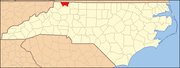 | |
| Townships | ||
| Unincorporated communities | ||
| International | |
|---|---|
| National | |