Shrewsbury, West Virginia
Shrewsbury, West Virginia | |
|---|---|
Census-designated place (CDP) | |
 Residential homes along the banks of the Kanawha River in Shrewsbury. | |
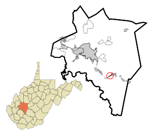
 Location in Kanawha County and state of West Virginia. | |
| Coordinates: 38°12′22″N 81°28′17″W / 38.20611°N 81.47139°W | |
| Country | United States |
| State | West Virginia |
| County | Kanawha |
| Area | |
| • Total | 0.435 sq mi (1.13 km2) |
| • Land | 0.350 sq mi (0.91 km2) |
| • Water | 0.085 sq mi (0.22 km2) |
| Elevation | 623 ft (190 m) |
| Population | |
| • Total | 652 |
| • Density | 1,500/sq mi (580/km2) |
| Time zone | UTC-5 (Eastern (EST)) |
| • Summer (DST) | UTC-4 (EDT) |
| Area code(s) | 304 & 681 |
| GNIS feature ID | 1546745[3] |
Shrewsbury is a census-designated place (CDP) and unincorporated community in Kanawha County, West Virginia, United States. Shrewsbury is located on the north bank of the Kanawha River along U.S. Route 60. As of the 2010 census, its population was 652.[2]
Like the nearby community of Dickinson, Shrewsbury was given its name due to the early history of the Dickinson and Shrewsbury families within the area.[4]
Shrewsbury is home to a Liberty gas station and convenience store, the Mason-Dixon Bar, and three churches; The Shrewsbury Church of God, Shrewsbury Community Church and the Shrewsbury Baptist Church.
References[edit]
- ^ "US Gazetteer files: 2010, 2000, and 1990". United States Census Bureau. February 12, 2011. Retrieved April 23, 2011.
- ^ a b "U.S. Census website". United States Census Bureau. Retrieved May 14, 2011.
- ^ U.S. Geological Survey Geographic Names Information System: Shrewsbury, West Virginia
- ^ Stealey, John Edmund (1993). "Virginia's Mercantile-Manufacturing Frontier: Dickinson & Shrewsbury and the Great Kanawha Salt Industry". The Virginia Magazine of History and Biography. 101 (4): 509–534. JSTOR 4249394.

