
Riverview Covered Bridge
(Redirected from Riverview Covered Pedestrian Bridge)
Riverview Covered Bridge | |
|---|---|
 | |
| Coordinates | 41°51′20″N 80°45′44″W / 41.8554390°N 80.7621500°W |
| Carries | pedestrians |
| Crosses | Ashtabula River |
| Locale | Ashtabula Township, Ohio |
| Characteristics | |
| Design | Pratt truss |
| Material | Wood |
| Total length | 150 feet (46 m) |
| Width | 14 feet (4.3 m) |
| History | |
| Constructed by | Smolen Engineering |
| Construction start | 2015 |
| Construction end | 2016 |
| Construction cost | $850,000 (equivalent to $1.08 million in 2023)[1] |
| Opened | October 4, 2016 |
| Location | |
 | |
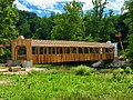
The Riverview Covered Pedestrian Bridge is a wooden Pratt truss covered bridge built beneath the Smolen-Gulf Bridge, completed in 2016.[2] The new pedestrian covered bridge is 150 feet (46 m) long and 14 feet (4.3 m) wide. It is a Pratt truss design, like the Smolen-Gulf Bridge, and was designed by Smolen Engineering. It sits below Smolen Bridge in Indian Trails Park. It was dedicated on October 4, 2016.

Gallery[edit]
-

-

-

-

-

-
-
 Interior view
.jpg)
.jpg)
.jpg)

.jpg)


See also[edit]
References[edit]
- ^ 1634–1699: McCusker, J. J. (1997). How Much Is That in Real Money? A Historical Price Index for Use as a Deflator of Money Values in the Economy of the United States: Addenda et Corrigenda (PDF). American Antiquarian Society. 1700–1799: McCusker, J. J. (1992). How Much Is That in Real Money? A Historical Price Index for Use as a Deflator of Money Values in the Economy of the United States (PDF). American Antiquarian Society. 1800–present: Federal Reserve Bank of Minneapolis. "Consumer Price Index (estimate) 1800–". Retrieved February 29, 2024.
- ^ Segall, Grant (3 October 2016). "Ashtabula County's 19th covered bridge will be dedicated Tuesday". cleveland.com. Advance Ohio. Retrieved 10 September 2017.
This article about a bridge in Ohio is a stub. You can help Wikipedia by expanding it. |