Pochon County
Poch'ŏn County
보천군 | |
|---|---|
| Korean transcription(s) | |
| • Chosŏn'gŭl | 보천군 |
| • Hancha | 普天郡 |
| • McCune–Reischauer | Poch'ŏn-gun |
| • Revised Romanization | Bocheon-gun |
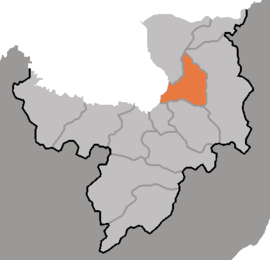
 Map of Ryanggang showing the location of Pochon | |
| Country | North Korea |
| Province | Ryanggang |
| Administrative divisions | 1 ŭp, 2 workers' districts, 17 ri |
| Area | |
| • Total | 783 km2 (302 sq mi) |
| Population (2008[1]) | |
| • Total | 37,225 |
| • Density | 48/km2 (120/sq mi) |
Poch'ŏn County is a kun, or county, in Ryanggang Province, North Korea. It looks westward across the Amrok River at China.
Geography[edit]
The Masingryong Mountains pass through the county, which slopes downward gradually to the west. The county sits atop the Paektu Plateau, with the mountains rising to only a small relative height. The highest peak is Namp'ot'aesan (남포태산). There are numerous streams, of which the chief is the Karimch'ŏn. Some 83% of the county's area is taken up by forestland. The temperatures are quite cold.
Economy[edit]
The predominant local industry is logging. There are also deposits of magnetite, alunite, and obsidian. Poch'ŏn's farms produce potatoes, wheat and barley, among other crops; orchards and livestock farms are also found.
Transportation[edit]
Poch'ŏn is served by the Samjiyŏn and Poch'ŏn (Paektusan Rimch'ŏl) lines of the Korean State Railway, and also by roads.
Administrative divisions[edit]
Pochon-gun is divided into 1 up (town), 2 rodongjagu (workers' districts) and 17 ri (villages):
| Chosŏn'gŭl | Hancha | |
|---|---|---|
| Poch'ŏn-ŭp | 보천읍 | 普天邑 |
| Taejil-lodongjagu | 대진로동자구 | 大鎭勞動者區 |
| Taep'yŏng-rodongjagu | 대평로동자구 | 大坪勞動者區 |
| Ch'ŏngrim-ri | 청림리 | 靑林里 |
| Hosal-li | 호산리 | 虎山里 |
| Hŭngsŏng-ri | 흥성리 | 興成里 |
| Hwajŏl-li | 화전리 | 樺田里 |
| Kasal-li | 가산리 | 佳山里 |
| Mun'am-ri | 문암리 | 門岩里 |
| Naegong-ri | 내곡리 | 內曲里 |
| Paekcha-ri | 백자리 | 柏子里 |
| Pohŭng-ri | 보흥리 | 保興里 |
| Ryongdŏng-ri | 룡덕리 | 龍德里 |
| Sangryong-ri | 상룡리 | 上龍里 |
| Sinhŭng-ri | 신흥리 | 新興里 |
| Songbong-ri | 송봉리 | 松峰里 |
| Taehŭng-ri | 대흥리 | 大興里 |
| Taesil-li | 대신리 | 大新里 |
| Ŭihwa-ri | 의화리 | 儀化里 |
| Unnam-ri | 운남리 | 雲南里 |
See also[edit]
- Geography of North Korea
- Administrative divisions of North Korea
- Ryanggang
- Battle of Pochonbo
- Pochonbo Electronic Ensemble
References[edit]
External links[edit]
- In Korean language online encyclopedias:

