
Pep, New Mexico
Pep | |
|---|---|
Unincorporated community | |
| Country | United States |
| State | New Mexico |
| County | Roosevelt |
| Time zone | UTC-7 (Mountain (MST)) |
| • Summer (DST) | UTC-6 (MDT) |
| ZIP Code | 88126 |
Pep[1] is an unincorporated community in southern Roosevelt County, in the southeastern part of the U.S. state of New Mexico. The community is composed almost entirely of farms and cattle ranches and is located approximately seven miles south of Dora on New Mexico State Road 206. The ZIP Code for Pep is 88126.[2]
The origin of the name "Pep" is obscure.[3]
Science fiction author Jack Williamson grew up on a ranch near Pep.
References[edit]
- ^ "Pep, New Mexico". Geographic Names Information System. United States Geological Survey, United States Department of the Interior.
- ^ "Pep ZIP Code". zipdatamaps.com. 2022. Retrieved November 11, 2022.
- ^ Moyer, Armond; Moyer, Winifred (1958). The origins of unusual place-names. Keystone Pub. Associates. pp. 141–142.
Municipalities and communities of Roosevelt County, New Mexico, United States | ||
|---|---|---|
| City | 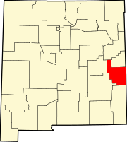 | |
| Town | ||
| Villages | ||
| Unincorporated communities | ||
| Ghost towns | ||
33°50′10″N 103°20′7″W / 33.83611°N 103.33528°W
This New Mexico state location article is a stub. You can help Wikipedia by expanding it. |