Nièvre (Loire)
| Nièvre | |
|---|---|
 | |
 | |
| Location | |
| Country | France |
| Physical characteristics | |
| Source | |
| • location | Burgundy |
| Mouth | |
• location | Loire |
• coordinates | 46°59′5″N 3°9′32″E / 46.98472°N 3.15889°E |
| Length | 49.6 km (30.8 mi) |
| Basin features | |
| Progression | Loire→ Atlantic Ocean |
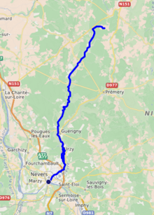
The Nièvre (IPA: [njɛvʁ] ⓘ) is a river in central France, a right tributary of the Loire. It flows through the département Nièvre.[1]
Its source is in Champlemy. It flows generally south, through Guérigny, Urzy, and empties into the Loire in the town centre of Nevers.
References[edit]
Wikimedia Commons has media related to Nièvre River.
