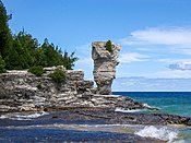
National Marine Conservation Area
National Marine Conservation Areas (NMCAs) is a Parks Canada programme responsible for marine areas managed for sustainability and containing smaller zones of high protection. They include the seabed, the water itself and any species which occur there. They may also include wetlands, estuaries, islands and other coastal lands.[1] They are protected from dumping, undersea mining and oil and gas exploration and development, which may damage the aquatic or terrestrial ecosystems in the conservation area. However, not all commercial activities are prohibited in these zones. Shipping, commercial and sport fishing, and recreational activities are allowed.[2][3]
Marine conservation at Nature Canada[edit]
In 1996, Nature Canada[4] developed its Marine Conservation Program in recognition that marine ecosystems were as affected by human activity as terrestrial ecosystems. At that time, Canada's National Parks Act[5] was designed to guide conservation and protection only on land. So that year, Nature Canada began advocating for new legislation that would enable the creation of national marine conservation areas.[6] Over the next several years we[who?] met with federal government policy decision-makers, gave testimony at hearings, and conducted a public awareness campaign about marine conservation areas.[7]
List of National Marine Conservation Areas[edit]
As of 2020[update], established NMCAs and NMCA Reserves protect 14,846 km2 (5,732 sq mi) of waters, wetlands, and coastlines, representing five of the 29 identified marine regions with studies underway for protected areas in three additional regions.[8]
| Name | Photo | Location | Established | Area (2017) | Marine region | Description |
|---|---|---|---|---|---|---|
| Fathom Five National Marine Park † | 
|
45°19′N 81°38′W / 45.317°N 81.633°W |
20 July 1987 | 114 km2 (44 sq mi) | Georgian Bay | The marine counterpart to the adjacent Bruce Peninsula National Park, Fathom Five is named for a line in Shakespeare's The Tempest. The first marine unit in the national parks system preserves a unique aquatic environment and several small islands including Flowerpot Island. The unusually clear waters and numerous shipwrecks on the shoals of Georgian Bay make the park a popular destination for scuba divers.[9]: 189 |
| Gwaii Haanas NMCA Reserve & Haida Heritage Site (Reserve) |

|
52°0′N 131°12′W / 52.000°N 131.200°W |
11 June 2010 | 1,500 km2 (579 sq mi)[10] | Hecate Strait, Queen Charlotte Shelf | Along with the National Park Reserve of the same name, Gwaii Haanas protects an area extending from the ocean floor of the Hecate Strait and Queen Charlotte Basin to the mountains of the Haida Gwaii. The marine reserve preserves the Haida people's traditional use of the waters while protecting the area from oil exploration and commercial fishing.[9]: 299 As a Reserve, it is a proposed NMCA, pending settlement of Native claims, but managed as a park unit in the interim. |
| Lake Superior NMCA | 
|
48°26′N 89°13′W / 48.433°N 89.217°W |
1 September 2015 | 10,880 km2 (4,201 sq mi) | Lake Superior | Adjacent to the United States' Isle Royale National Park and several Ontario provincial parks, Lake Superior NMCA forms part of the world's largest freshwater reserve.[11] |
| Saguenay–St. Lawrence Marine Park† | 
|
48°4′N 69°40′W / 48.067°N 69.667°W |
8 June 1998 | 1,245 km2 (481 sq mi)[12] | St. Lawrence Estuary | Located at the confluence of the Saguenay and St. Lawrence rivers and adjacent to Quebec's "Saguenay Fjord National Park" (a provincial park), Saguenay–St. Lawrence protects a portion of the St. Lawrence estuary, a common feeding ground for marine mammals such as the endangered St. Lawrence beluga whale. |
Proposed National Marine Conservation Areas[edit]
See also[edit]
References[edit]
- ^ Canada, Parks Canada Agency, Government of. "National Marine Conservation Areas". www.pc.gc.ca. Retrieved February 7, 2018.
{{cite web}}: CS1 maint: multiple names: authors list (link) - ^ "Ottawa to create protected zone in northern Lake Superior". CBC News. 2007-10-24. Retrieved 2007-10-25.
- ^ "Canada sets largest freshwater conservation area". Reuters. 2007-10-25. Retrieved 2007-10-26.
- ^ "Nature Canada". NatureCanada.ca. Retrieved February 7, 2018.
- ^ Branch, Legislative Services. "Consolidated federal laws of canada, Canada National Parks Act". laws-lois.justice.gc.ca. Retrieved February 7, 2018.
- ^ Canada, Parks Canada Agency, Government of. "Find a National Marine Conservation Area". www.pc.gc.ca. Retrieved February 7, 2018.
{{cite web}}: CS1 maint: multiple names: authors list (link) - ^ "Nature Canada – National marine conservation area". NatureCanada.ca. Retrieved 2017-10-18.
- ^ a b "Completing the National Marine Conservation Areas System". Parks Canada. 30 March 2017. Retrieved 25 January 2017.
- ^ a b Guide to the National Parks of Canada. Washington, D.C.: National Geographic. 2017. ISBN 978-1-4262-1756-2.
- ^ "Minister visits, celebrates marine park's creation". Haida Gwaii Observer. 14 June 2010. Retrieved 15 December 2017.
- ^ "Canada creates world's biggest water reserve". Agence France-Presse. 25 October 2007. Archived from the original on 5 January 2008. Retrieved 23 January 2018.
- ^ Saguenay-St. Lawrence Marine Park (PDF) (Map). Ministère du Développement durable, de l'Environnement et des Parcs du Québec. Retrieved 17 February 2018.
- ^ Rochette, Lise (9 May 2012). "Study on the Creation of a Marine Protected Area in Îles-de-la-Madeleine" (Press release). Cap-aux-Meules, QC: Parks Canada & Government of Quebec. Retrieved 15 December 2017.
- ^ Departmental Performance Report 2013-14 (Report). Gatineau, QC: Parks Canada. 31 March 2014. Retrieved 18 January 2018.
- ^ Feasibility Study for the Proposed Southern Strait of Georgia National Marine Conservation Area Reserve (Report). Parks Canada. 30 March 2017. Retrieved 15 December 2017.
