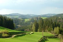
Mühlviertel

The Mühlviertel (German pronunciation: [ˈmyːlˌfɪʁtl̩]) is an Austrian region belonging to the state of Upper Austria: it is one of four "quarters" of Upper Austria, the others being Hausruckviertel, Traunviertel, and Innviertel. It is named after the three rivers Große Mühl, Kleine Mühl, and Steinerne Mühl.


Region[edit]
The Mühlviertel consists of the four Upper Austrian districts that lie north of the river Danube: Rohrbach, Urfahr-Umgebung, Freistadt and Perg. The parts of the state capital Linz that lie north of the Danube also belong to the Mühlviertel. Geologically it is a part of the Bohemian Massif. Major towns include Rohrbach, Bad Leonfelden, Freistadt and Perg.
History[edit]
The region was the site of a notorious war crime at the end of World War II in which hundreds of starving Soviet POWs escaped from nearby Mauthausen concentration camp and were pursued and murdered around Mühlviertel. The SS referred to the event as the Mühlviertler Hasenjagd ("Mühlviertel rabbit hunt"). During the Allied occupation of Austria after World War II, the Mühlviertel belonged to the Soviet occupation zone, and the rest of Upper Austria belonged to the American occupation zone.
