
Mount Spokane
| Mount Spokane | |
|---|---|
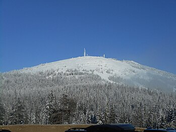
 View from northeast Spokane in 2008 | |
| Highest point | |
| Elevation | 5,887 ft (1,794 m) NAVD 88[1] |
| Prominence | 3,503 ft (1,068 m)[2] |
| Isolation | 53.5 mi |
| Listing | |
| Coordinates | 47°55′25″N 117°06′44″W / 47.9236°N 117.1122°W[1] |
| Geography | |
 Mount Spokane (the United States) | |
| Parent range | Selkirk Mountains |
| Topo map | USGS Mount Spokane |
| Climbing | |
| Easiest route | |

Mount Spokane [elevation 5,887 feet (1,794 m)]—previously known as Mount Baldy until 1912[3] due to its pronounced bald spot—is a mountain in the northwest United States, located northeast of Spokane, Washington. Its summit is the highest point in Spokane County,[2] and it is one of the tallest peaks in the Inland Northwest. Mount Spokane is surrounded by Mount Spokane State Park, Washington's largest at 13,919 acres (56.3 km2). One of the well-known features is a bald spot on the corner of the west and south parts of the mountain.
Mount Kit Carson—the second highest peak in Spokane County—is located only 1.02 miles (1.64 km) to the east, and with a topographic prominence of only 322 feet (98 m) could be considered a satellite peak of Mount Spokane.
A non-profit organization operates the Mount Spokane Ski and Snowboard Park, located on the southwest portion of the mountain.
Climate[edit]
Mount Spokane has a dry summer humid continental climate (Köppen Dsb) with a subarctic climate (Köppen Dfc) influence.
| Climate data for Mount Spokane 47.9223 N, 117.1155 W, Elevation: 5,554 ft (1,693 m) (1991–2020 normals) | |||||||||||||
|---|---|---|---|---|---|---|---|---|---|---|---|---|---|
| Month | Jan | Feb | Mar | Apr | May | Jun | Jul | Aug | Sep | Oct | Nov | Dec | Year |
| Mean daily maximum °F (°C) | 28.0 (−2.2) |
30.7 (−0.7) |
36.9 (2.7) |
45.0 (7.2) |
54.1 (12.3) |
60.5 (15.8) |
71.5 (21.9) |
71.8 (22.1) |
62.0 (16.7) |
47.6 (8.7) |
33.1 (0.6) |
26.9 (−2.8) |
47.3 (8.5) |
| Daily mean °F (°C) | 23.6 (−4.7) |
25.2 (−3.8) |
30.1 (−1.1) |
36.9 (2.7) |
46.1 (7.8) |
51.2 (10.7) |
61.1 (16.2) |
61.5 (16.4) |
52.8 (11.6) |
40.1 (4.5) |
28.7 (−1.8) |
22.1 (−5.5) |
40.0 (4.4) |
| Mean daily minimum °F (°C) | 19.1 (−7.2) |
19.7 (−6.8) |
23.4 (−4.8) |
28.8 (−1.8) |
38.1 (3.4) |
42.0 (5.6) |
50.7 (10.4) |
51.1 (10.6) |
43.5 (6.4) |
32.6 (0.3) |
24.4 (−4.2) |
17.3 (−8.2) |
32.6 (0.3) |
| Average precipitation inches (mm) | 5.34 (136) |
3.77 (96) |
5.72 (145) |
3.74 (95) |
2.94 (75) |
2.82 (72) |
1.29 (33) |
1.02 (26) |
2.05 (52) |
3.43 (87) |
6.03 (153) |
5.81 (148) |
43.96 (1,118) |
| Source: PRISM Climate Group[4] | |||||||||||||
| Climate data for Mount Spokane, Washington, July 1953 – December 1972 | |||||||||||||
|---|---|---|---|---|---|---|---|---|---|---|---|---|---|
| Month | Jan | Feb | Mar | Apr | May | Jun | Jul | Aug | Sep | Oct | Nov | Dec | Year |
| Record high °F (°C) | 47 (8) |
50 (10) |
54 (12) |
72 (22) |
77 (25) |
83 (28) |
89 (32) |
89 (32) |
81 (27) |
68 (20) |
59 (15) |
46 (8) |
89 (32) |
| Mean daily maximum °F (°C) | 23.1 (−4.9) |
27.6 (−2.4) |
30.3 (−0.9) |
38.2 (3.4) |
49.0 (9.4) |
57.4 (14.1) |
66.5 (19.2) |
66.0 (18.9) |
56.4 (13.6) |
43.1 (6.2) |
32.5 (0.3) |
26.5 (−3.1) |
43.0 (6.1) |
| Daily mean °F (°C) | 18.1 (−7.7) |
23.0 (−5.0) |
24.8 (−4.0) |
31.5 (−0.3) |
42.0 (5.6) |
49.2 (9.6) |
57.9 (14.4) |
57.4 (14.1) |
48.6 (9.2) |
36.9 (2.7) |
27.5 (−2.5) |
21.7 (−5.7) |
36.6 (2.5) |
| Mean daily minimum °F (°C) | 13.1 (−10.5) |
18.4 (−7.6) |
19.4 (−7.0) |
24.9 (−3.9) |
35.0 (1.7) |
41.1 (5.1) |
49.3 (9.6) |
48.8 (9.3) |
40.9 (4.9) |
30.8 (−0.7) |
22.5 (−5.3) |
16.9 (−8.4) |
30.1 (−1.1) |
| Record low °F (°C) | −23 (−31) |
−17 (−27) |
−20 (−29) |
10 (−12) |
15 (−9) |
21 (−6) |
25 (−4) |
28 (−2) |
18 (−8) |
4 (−16) |
−17 (−27) |
−28 (−33) |
−28 (−33) |
| Average precipitation inches (mm) | 5.83 (148) |
4.61 (117) |
4.94 (125) |
3.49 (89) |
2.78 (71) |
2.71 (69) |
1.30 (33) |
1.54 (39) |
2.75 (70) |
3.71 (94) |
6.24 (158) |
6.25 (159) |
46.15 (1,172) |
| Average snowfall inches (cm) | 39.1 (99) |
20.5 (52) |
25.9 (66) |
10.9 (28) |
5.0 (13) |
0.6 (1.5) |
0.2 (0.51) |
0 (0) |
1.9 (4.8) |
8.1 (21) |
18.2 (46) |
32.2 (82) |
162.5 (413) |
| Source: Western Regional Climate Center[5] | |||||||||||||
Gallery[edit]
-
 View of the summit in 2016
 -
 View from the southwest in 2007
 -
 View from the southwest in the 1920s


References[edit]
- ^ a b "Y". NGS Data Sheet. National Geodetic Survey, National Oceanic and Atmospheric Administration, United States Department of Commerce.
- ^ a b "Mount Spokane, Washington". Peakbagger.com.
- ^ Rebstock, Tracy. "Mount Spokane". Spokane Historical. Eastern Washington University. Retrieved May 15, 2022.
- ^ "PRISM Climate Group, Oregon State University". PRISM Climate Group, Oregon State University. Retrieved September 28, 2023.
To find the table data on the PRISM website, start by clicking Coordinates (under Location); copy Latitude and Longitude figures from top of table; click Zoom to location; click Precipitation, Minimum temp, Mean temp, Maximum temp; click 30-year normals, 1991-2020; click 800m; click Retrieve Time Series button.
- ^ "MT SPOKANE SUMMIT, WASHINGTON (455674)". Western Regional Climate Center. 2013. Retrieved on August 26, 2015.
External links[edit]
- "Mount Spokane". Geographic Names Information System. United States Geological Survey, United States Department of the Interior.
- "Mount Spokane state park". Washington State Parks. Archived from the original on January 10, 2011. Retrieved January 13, 2011.
This Spokane County, Washington state location article is a stub. You can help Wikipedia by expanding it. |