
Manitou, Kentucky
Manitou, Kentucky | |
|---|---|
 Manitou  Manitou | |
| Coordinates: 37°22′32″N 87°34′41″W / 37.37556°N 87.57806°W | |
| Country | United States |
| State | Kentucky |
| County | Hopkins |
| Area | |
| • Total | 0.66 sq mi (1.72 km2) |
| • Land | 0.66 sq mi (1.71 km2) |
| • Water | 0.01 sq mi (0.01 km2) |
| Elevation | 407 ft (124 m) |
| Population (2020) | |
| • Total | 173 |
| • Density | 262.52/sq mi (101.32/km2) |
| Time zone | UTC-6 (Central (CST)) |
| • Summer (DST) | UTC-5 (CST) |
| ZIP code | 42436 |
| FIPS code | 21-49746 |
| GNIS feature ID | 2629646[2] |
Manitou (/ˈmænɪtuː/) is an unincorporated community and census-designated place (CDP) in Hopkins County, Kentucky, United States. As of the 2010 census the population was 181.[3] It is a small community that lies a few miles northwest of Madisonville on US 41, at its intersection with KY 630 and KY 262.
Demographics[edit]
| Census | Pop. | Note | %± |
|---|---|---|---|
| 2020 | 173 | — | |
| U.S. Decennial Census[4] | |||
References[edit]
- ^ "2020 U.S. Gazetteer Files". United States Census Bureau. Retrieved March 18, 2022.
- ^ U.S. Geological Survey Geographic Names Information System: Manitou, Kentucky
- ^ "Geographic Identifiers: 2010 Demographic Profile Data (G001): Manitou CDP, Kentucky". American Factfinder. U.S. Census Bureau. Retrieved July 10, 2017.[dead link]
- ^ "Census of Population and Housing". Census.gov. Retrieved June 4, 2016.
Municipalities and communities of Hopkins County, Kentucky, United States | ||
|---|---|---|
| Cities | 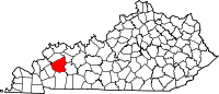 | |
| CDP | ||
| Other unincorporated communities | ||
| Footnotes | ‡This populated place also has portions in an adjacent county or counties | |
This Hopkins County, Kentucky state location article is a stub. You can help Wikipedia by expanding it. |