
Manatuto
You can help expand this article with text translated from the corresponding article in German. (November 2010) Click [show] for important translation instructions.
|
Manatuto | |
|---|---|
City | |
 | |
 Manatuto Location in East Timor | |
| Coordinates: 8°30′44″S 126°00′57″E / 8.51222°S 126.01583°E | |
| Country | |
| Municipality | Manatuto |
| Administrative post | Manatuto |
| Area | |
| • Total | 271.38 km2 (104.78 sq mi) |
| Elevation | 0 m (0 ft) |
| Population (2010) | |
| • Total | 3,692 |
| • Density | 14/km2 (35/sq mi) |
| Time zone | UTC+09:00 (TLT) |
| Climate | BSh |
Manatuto is a city in Manatuto Municipality, East Timor.
Manatuto Vila has 3,692 inhabitants (Census 2015) and is capital of the subdistrict and district Manatuto. It is on the north coast of Timor, 64 km (40 mi) (about 50 km (31 mi) as the crow flies[1]: 1 ) east of Dili, the national capital, on the way to Baucau. The capital is known for its salt production and abundance of tamarind.
Geography[edit]
Manatuto city is generally flat and low-lying, with single hills on its southern outskirts. It extends for approximately 6 km (3.7 mi) from the eastern end of Obrato aldeia in Suco Sau to the western end of the Maabat aldeia in Suco Maabat. It also stretches about 2 km (1.2 mi) south from Wetar Strait in its north.[1]: 1
Dumi Huhun (156 m (512 ft) AMSL), in the city's southeast near the main road connecting Dili and Baucau, is the tallest of its hills. Another hill, Saututu Hill (90 m (300 ft) AMSL), is on the eastern side of the city, along the road connecting Manatuto and the small community of Carlilu to its south.[1]: 1
Governance[edit]
The city is the capital of Manatuto municipality, and is made up of four urban sucos. From west to east, the sucos are: Sau, Ailili, Aiteas, and Maabat. According to the 2010 census, urban sucos are those co-located with municipal capitals, or with certain qualities of population and social amenities. In the case of Manatuto, the city is in effect the urbanised part of the four sucos.[1]: 1
Manatuto suffered an excessive amount of damage and high murder rate in 1999 compared to other locations.[citation needed] The town is still being re-built.[citation needed]
-
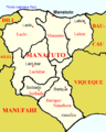 Map of Manatuto district
 -
![Climate[2]](//upload.wikimedia.org/wikipedia/commons/thumb/7/72/Manatuto_Klimadiagramm.png/120px-Manatuto_Klimadiagramm.png) Climate[2]
Climate[2]

![Climate[2]](/wiki/File:Manatuto_Klimadiagramm.png)
References[edit]
- ^ a b c d District Capitals Water Supply Project: Initial Environmental Examination of the Expansion, Rehabilitation and Operation and Maintenance of Manatuto Water Supply Systems (PDF) (Report). Ministry of Infrastructure for the Asian Development Bank. September 2011. TIM 44130-02. Retrieved 9 June 2022.
- ^ Seeds of Life
External links[edit]
![]() Media related to Manatuto (city) at Wikimedia Commons
Media related to Manatuto (city) at Wikimedia Commons
Capitals of Municipalities of East Timor | ||
|---|---|---|
This East Timor location article is a stub. You can help Wikipedia by expanding it. |