Little San Salvador Island

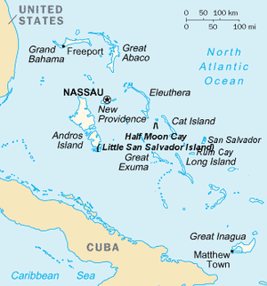
Little San Salvador Island, also known as Half Moon Cay, is one of about 700 islands that make up the archipelago of The Bahamas. It is located roughly halfway between Eleuthera and Cat Island, administratively in the Cat Island District.[1] It is a private island, owned by Carnival Corporation & plc, which uses it as a port of call for the cruise ships it operates in the region. Prior to being owned by Carnival, Little San Salvador was the private island of Norwegian Cruise Line.

Little San Salvador Island is located about 100 miles (160 kilometres) southeast of Nassau. Holland America Line purchased the island in December 1996 for a price of US$6 million. It has since developed 50 acres (200,000 m2) of the 2,400-acre (9.7 km2) island, with the stated goal of maintaining as much habitat as possible for wildlife. The island is also a significant nesting area for waterfowl. The island does not have deep water docking, requiring the use of tenders for cruise ship passengers to disembark and embark.[2]
Activities offered on the island include swimming, sunbathing, scuba diving, jet-skiing, cycling, and snorkeling. Deep-sea fishing, parasailing, glass-bottom boat rides, and nature walks also are available. A variety of water toys are available for rent, including Hobie catamarans, Sunfish sailboats, windsurfing sailboards, and kayaks. There are volleyball and basketball courts, horseshoes, shuffleboard, a fitness trail with exercise stations, horseback riding, and nature trails for hiking.
Etymology[edit]
The indigenous Lucayan people called the island Guateo, meaning "distant land".[3]
References[edit]
- ^ "GeoNames.org". www.geonames.org. Retrieved 2020-08-03.
- ^ "Cruise to Half Moon Cay | Bahamas Vacations | Carnival".
- ^ Ahrens, Wolfgang P. (2015). "Naming the Bahamas Islands: History and Folk Etymology". Onomastica Canadiana. 94 (2): 101. ISSN 2816-7015.
External links[edit]
24°34′26″N 75°57′07″W / 24.574°N 75.952°W

