
Lingo, New Mexico
Lingo, New Mexico | |
|---|---|
 Lingo Location within New Mexico  Lingo Location within the United States | |
| Coordinates: 33°47′18″N 103°06′53″W / 33.78833°N 103.11472°W | |
| Country | United States |
| State | New Mexico |
| County | Roosevelt |
| Founded | 1916 (as "Need") |
| Elevation | 3,983 ft (1,214 m) |
| Time zone | UTC−07:00 (Mountain) |
| ZIP code | 88123[2] |
| Area code | 575 |
| GNIS feature ID | 915847[1] |
Lingo is a populated place in Roosevelt County, New Mexico, United States.[1] The original name given the settlement in 1916 was “Need”, but U.S. postal authorities said that was too much like “Weed” in Otero County,[3] so in 1918 the name was changed to "Lingo".
The community post office was originally located three miles south of the current location on New Mexico State Road 114, seven miles south of Causey and five miles from the Texas border.[4]
An early authority on New Mexico place names states the name was derived from the Southwestern colloquial term "lingo" (from Latin lingua tongue),[3] but a later authority states that the name more likely resulted from a family name.[4]
References[edit]
- ^ a b c U.S. Geological Survey Geographic Names Information System: Lingo, New Mexico
- ^ "Lingo ZIP Code". zipdatamaps.com. 2022. Retrieved November 30, 2022.
- ^ a b Pearce, T.M. (editor) with Cassidy, Ina Sizer and Pearce, Helen S. (1965) "Lingo" New Mexico Place Names; A Geographical Dictionary University of New Mexico Press, Albuquerque, New Mexico, page 88
- ^ a b Julyan, Robert Hixson (1998) "Lingo" The Place Names of New Mexico (second edition) University of New Mexico Press, Albuquerque, New Mexico, page 204, ISBN 0-8263-1689-1
Municipalities and communities of Roosevelt County, New Mexico, United States | ||
|---|---|---|
| City | 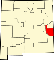 | |
| Town | ||
| Villages | ||
| Unincorporated communities | ||
| Ghost towns | ||