Les Cheneaux Islands
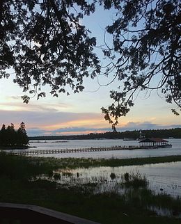
 Sunset from Marquette Island, May 2016 | |
| Geography | |
|---|---|
| Location | Lake Huron |
| Coordinates | 45°57′34″N 84°19′29″W / 45.95944°N 84.32472°W |
| Total islands | 36 |
| Administration | |
| State | Michigan |
| County | Mackinac County |
| Township | Clark Township |
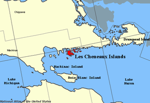
Les Cheneaux Islands (French: "The Channels") are an archipelago of 36 small islands, some inhabited, along 12 miles of Lake Huron shoreline on the southeastern tip of the Upper Peninsula of Michigan in the United States. The name is French for "the Channels", noting the many channels between the islands in the group.[1] They are about 30 miles northeast of Mackinac Island and about 35 miles south of Sault Ste. Marie. The islands are a popular resort and boating and kayaking area. The nearby communities of Hessel and Cedarville on the mainland offer marinas, camping, lodging, restaurants, and shopping. The Les Cheneaux Islands Antique Boat Show & Festival of the Arts has been held on the second Saturday of each August since 1976 in Hessel. It is the world's largest antique wooden boat show.
History[edit]
The area that encompasses Les Cheneaux was traditionally occupied by the Wyandotte and the Odawa people. In 1634, French colonial explorer Jean Nicolet navigated the channels of Les Cheneaux while attempting to reach Michillimackinac via Lake Huron (then referred to as Mer Douce). He was accompanied by seven Wyandotte tribesmen.[2] Nicolet and later explorers noted that the locals referred to the chain as Onomonee or Anaminang, derived from the Odawa word for "island", minis.[3] Jacques Marquette would be the first European to draw a map of Les Cheneaux, while navigating it during the summer of 1671.[4]
By the late 17th century, the fur trade dominated the island chain.[5]
Overview of Area[edit]
32 of the 36 islands are named. They include:
- Alligator Island
- Bear Island
- Birch Island
- Boot Island
- Burnham Island
- Coryell Island
- Cove Island
- Crow Island
- Dollar Island
- Echo Island
- Eagle Island
- Goat Island
- Goose Island
- Government Island
- Gravelly Island
- Haven Island
- Hill Island
- Holsinger Island
- Island No. 8
- La Salle Island
- Little Island (A.K.A. "Skunk Island")
- Little Joe's Island (A.K.A. "White Loon Island")
- Little La Salle Island
- Lone Susan Island
- Long Island
- Marquette Island
- Penny Island
- Rodger Island
- Rover Island
- St. Ledger Island
- Strongs Island
- Winona Island
The island chain forms many bays, harbors, and inland lakes, including:
- Bass Cove Lake
- Bush Bay
- Cedarville Bay
- Duck Bay
- Flower Bay
- Government Bay
- Mackinac Bay
- Marquette Bay
- McKay Bay
- Melchers Bay
- Mismer Bay
- Muscallonge Bay
- Peck Bay
- Prentiss Bay
- Sand Bay
- Scammons Harbor
- Sheppard Bay
- Urie Bay
- Voight Bay
- Wilderness Bay
Les Cheneaux Ensign Class: Fleet 31[edit]
The Les Cheneaux Islands are home to Fleet 31 of the Ensign Class. The fleet sails out of the Les Cheneaux Yacht Club [1] located on Marquette Island. It is the largest fleet of ensigns worldwide, featuring 64 boats sailing as of summer 2008. Fleet 31 [2] hosted the 2008 Ensign Class Region V Championships on July 10–12, 2008. Fleet 31 was selected by the Ensign Class Association to host the National Ensign Regatta in 2010.
References[edit]
Citations[edit]
- ^ Creager, Ellen (July 19, 2016). "Find peace with a paddle in Michigan's Les Cheneaux islands". Detroit Free Press. Retrieved June 18, 2022.
- ^ Grover (1911), p. 16.
- ^ Grover (1911), p. 14.
- ^ Grover (1911), p. 19.
- ^ Grover (1911), p. 10.
Sources[edit]
- Grover, Frank R. (1911). A Brief History of Les Cheneaux Islands. Bowman Publishing Company.


