
Langres
Langres | |
|---|---|
Subprefecture and commune | |
 View of Langres from the southeast | |
 Flag .svg) Coat of arms | |
Location of Langres  | |
 Langres  Langres | |
| Coordinates: 47°51′48″N 5°20′02″E / 47.8633°N 5.3339°E | |
| Country | France |
| Region | Grand Est |
| Department | Haute-Marne |
| Arrondissement | Langres |
| Canton | Langres |
| Intercommunality | Grand Langres |
| Government | |
| • Mayor (2020–2026) | Anne Cardinal[1] |
| Area 1 | 22.33 km2 (8.62 sq mi) |
| Population (2021)[2] | 7,697 |
| • Density | 340/km2 (890/sq mi) |
| Time zone | UTC+01:00 (CET) |
| • Summer (DST) | UTC+02:00 (CEST) |
| INSEE/Postal code | 52269 /52200 |
| Elevation | 327–475 m (1,073–1,558 ft) (avg. 475 m or 1,558 ft) |
| 1 French Land Register data, which excludes lakes, ponds, glaciers > 1 km2 (0.386 sq mi or 247 acres) and river estuaries. | |
Langres (French pronunciation: [lɑ̃ɡʁ] ⓘ) is a commune in northeastern France. It is a subprefecture of the department of Haute-Marne, in the region of Grand Est.
History[edit]
As the capital of the Romanized Gallic tribe known as the Lingones, it was called Andematunnum, then Lingones, and now Langres.
A hilltop town, Langres was built on a limestone promontory of the same name. This stronghold was originally occupied by the Lingones. At a later date the Romans fortified the town, which they called Andemantunum, located at a strategic crossroads of twelve Roman roads.[citation needed] The first-century Triumphal Gate and the many artefacts exhibited in the museums are remnants of the town's Gallo-Roman history. After the period of invasions, the town prospered in the Middle Ages, due in part to the growing political influence of its bishops. The diocese covered Champagne, the Duchy of Burgundy, and Franche-Comté, and the bishops obtained the right to coin money in the ninth century and to name the military governor of the city in 927. The Bishop of Langres was a duke and peer of France. The troubled 14th and 15th centuries caused the town to strengthen its defenses, which still give the old city its fortified character, and Langres entered a period of royal tutelage. The Renaissance, which returned prosperity to the town, saw the construction of numerous fine civil, religious and military buildings that still stand today. In the 19th century, a "Vauban" citadel was added.
Main sights[edit]
Langres has a historic town center surrounded by defensive walls with a dozen towers and seven gates.
The cathedral of Saint-Mammès is a late 12th-century structure dedicated to Mammes of Caesarea, a 3rd-century martyr.
Culture[edit]
Langres is home to producers of an AOC-protected cheese of the same name. It is a soft, pungent cow's milk cheese that is known for its rind, which is washed.
The town was long known for its cutlery industry. Didier Diderot, father of encyclopedist Denis, was a cutler.[3]
A museum called the Denis Diderot House of Enlightenment opened in 2013. This museum, set up in a private mansion from the 16th and 18th centuries, is dedicated to the philosopher Denis Diderot.[4]
Population[edit]
| Year | Pop. | ±% p.a. |
|---|---|---|
| 1968 | 11,001 | — |
| 1975 | 11,437 | +0.56% |
| 1982 | 10,468 | −1.26% |
| 1990 | 9,987 | −0.59% |
| 1999 | 9,586 | −0.45% |
| 2007 | 8,414 | −1.62% |
| 2012 | 7,905 | −1.24% |
| 2017 | 7,731 | −0.44% |
| Source: INSEE[5] | ||
Notable people[edit]
Langres was the birthplace of:
- Nicolas Ribonnier (ca.1525–1605), Renaissance architect
- Jeanne Mance (1606–1673), the co-founder of Montreal
- Claude Gillot (1673–1722), painter
- Denis Diderot (1713–1784), the philosopher of the Age of Enlightenment, and the editor-in-chief of the Encyclopédie.
- Étienne Jean Bouchu (1714–1773), metallurgist and Encyclopédiste
- Nicolas Fallet (1746–1801), playwright and journalist
- Joseph-Philibert Girault de Prangey (1804–1892), photographer and draughtsman
- Jules Violle (1841–1923), physicist and inventor
- Guy Fréquelin (born 1945), rally driver
- Jean Tabourot, who went by the pen name Thoinot Arbeau and wrote Orchésographie, a book on dance and music.
Climate[edit]
Located in the north-east quarter of France, Langres is under the influence of both an oceanic climate and a humid continental climate with no dry season. Winters are cold and snowy (33.4 days of snow per year on average) but interspersed with periods of light thaw and summers are mild and even pleasant with average maximum temperatures around 23 °C (73 °F).
| Climate data for Langres (1981–2010 averages) | |||||||||||||
|---|---|---|---|---|---|---|---|---|---|---|---|---|---|
| Month | Jan | Feb | Mar | Apr | May | Jun | Jul | Aug | Sep | Oct | Nov | Dec | Year |
| Record high °C (°F) | 14.5 (58.1) |
20.4 (68.7) |
24.6 (76.3) |
26.3 (79.3) |
29.8 (85.6) |
35.0 (95.0) |
38.8 (101.8) |
37.6 (99.7) |
32.5 (90.5) |
27.6 (81.7) |
21.1 (70.0) |
15.5 (59.9) |
38.8 (101.8) |
| Mean daily maximum °C (°F) | 3.4 (38.1) |
5.1 (41.2) |
9.4 (48.9) |
13.1 (55.6) |
17.4 (63.3) |
20.8 (69.4) |
23.5 (74.3) |
23.2 (73.8) |
18.9 (66.0) |
13.8 (56.8) |
7.6 (45.7) |
4.1 (39.4) |
13.4 (56.1) |
| Daily mean °C (°F) | 1.0 (33.8) |
2.2 (36.0) |
5.8 (42.4) |
8.8 (47.8) |
13.0 (55.4) |
16.2 (61.2) |
18.7 (65.7) |
18.5 (65.3) |
14.7 (58.5) |
10.5 (50.9) |
5.0 (41.0) |
1.9 (35.4) |
9.7 (49.4) |
| Mean daily minimum °C (°F) | −1.3 (29.7) |
−0.7 (30.7) |
2.1 (35.8) |
4.6 (40.3) |
8.7 (47.7) |
11.7 (53.1) |
13.9 (57.0) |
13.9 (57.0) |
10.6 (51.1) |
7.2 (45.0) |
2.4 (36.3) |
−0.3 (31.5) |
6.1 (43.0) |
| Record low °C (°F) | −18.1 (−0.6) |
−21.2 (−6.2) |
−13.2 (8.2) |
−6.6 (20.1) |
−2.9 (26.8) |
2.5 (36.5) |
5.1 (41.2) |
5.1 (41.2) |
2.1 (35.8) |
−4.5 (23.9) |
−10.7 (12.7) |
−16.4 (2.5) |
−21.2 (−6.2) |
| Average precipitation mm (inches) | 80.5 (3.17) |
64.9 (2.56) |
65.5 (2.58) |
59.9 (2.36) |
82.4 (3.24) |
70.0 (2.76) |
74.4 (2.93) |
67.1 (2.64) |
72.1 (2.84) |
86.8 (3.42) |
83.5 (3.29) |
88.4 (3.48) |
895.5 (35.26) |
| Average precipitation days | 12.4 | 10.6 | 11.4 | 10.4 | 12.6 | 10.3 | 9.5 | 8.9 | 9.4 | 11.9 | 11.9 | 12.9 | 132.0 |
| Average snowy days | 7.6 | 6.9 | 5.4 | 3.2 | 0.3 | 0.0 | 0.0 | 0.0 | 0.0 | 0.3 | 3.5 | 6.2 | 33.4 |
| Average relative humidity (%) | 90 | 84 | 78 | 72 | 74 | 73 | 71 | 74 | 79 | 86 | 89 | 91 | 80.1 |
| Mean monthly sunshine hours | 61.7 | 86.3 | 139.1 | 171.9 | 194.0 | 213.9 | 225.8 | 219.6 | 169.6 | 111.9 | 60.7 | 48.4 | 1,702.8 |
| Source 1: Météo France[6][7] | |||||||||||||
| Source 2: Infoclimat.fr (humidity and snowy days, 1961–1990)[8] | |||||||||||||
International relations[edit]
Langres is twinned with:
 Beaconsfield, United Kingdom - since 1995[9]
 Ellwangen, Germany - since 1964
 Abbiategrasso, Italy
See also[edit]
- Bishopric of Langres
- The Langres war memorial has a sculpture by Georges Saupique
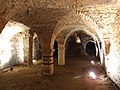
Gallery[edit]
-
 Road sign announcing improvements to the Citadel of Langres
 -
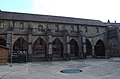
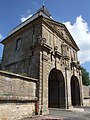
 Saint-Mammès Cathedral
 -
 Saint-Mammès Cathedral
 -
 Saint-Mammès Cathedral
 -
 Saint-Mammès Cathedral
 -
 Saint-Mammès Cathedral Cloister
 -
 Saint-Mammès Cathedral Cloister
 -
 Bas relief at Saint-Mammès Cathedral
 -
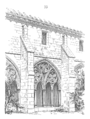
 Moulins Gate
 -
 Moulins Gate
 -
 Moulins Gate
 -
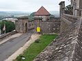
 Ramparts of the Citadel
 -
 Ramparts and Funicular
 -
 Saint-Ferjeux Tower
 -
 Navarre and d'Orval Tower
 -
 Navarre and d'Orval Tower
 -
 Navarre and d'Orval Tower ceiling framework
 -
 Navarre and d'Orval Tower torch holder
 -
 Navarre and d'Orval Tower torch holder
 -
 Navarre and d'Orval Tower gargoyle
 -
 Navarre and d'Orval Tower
 -
 Navarre and d'Orval Tower
 -
 Navarre and d'Orval Tower
 -
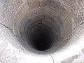 Navarre and d'Orval Tower well
 -
 Navarre and d'Orval Tower vaulted arch
 -
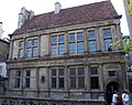
 Former Jesuit College
 -
 Renaissance cellar
 -
 Entrance to City Hall
 -
 Statue of Denis Diderot
 -
 Renaissance period mansion
 -
 Renaissance period mansion
 -
 Henriot Square
 -
 Saint-Martin Church


References[edit]
- ^ "Répertoire national des élus: les maires" (in French). data.gouv.fr, Plateforme ouverte des données publiques françaises. 13 September 2022.
- ^ "Populations légales 2021". The National Institute of Statistics and Economic Studies. 28 December 2023.
- ^ Génin, M.F. (1862). Œuvres choisies de Diderot, précédées de sa vie [Selected Works of Diderot, Prefaced with his Biography] (in French). Paris: Librairie de Firmin Didot Frères, Fils et Compagnie.
- ^ "Maison des Lumières Denis Diderot | Musées de Langres - Maison des Lumières Denis Diderot - Musée d'Art et d'Histoire". www.musees-langres.fr. Retrieved 24 January 2022.
- ^ Population en historique depuis 1968, INSEE
- ^ "Données climatiques de la station de Langres" (in French). Meteo France. Retrieved 31 December 2015.
- ^ "Climat Champagne-Ardenne" (in French). Meteo France. Retrieved 31 December 2015.
- ^ "Normes et records 1961-1990: Langres (52) - altitude 467m" (in French). Infoclimat. Retrieved 31 December 2015.
- ^ "British towns twinned with French towns". Archant Community Media Ltd. Archived from the original on 5 July 2013. Retrieved 11 July 2013.
External links[edit]
- Catholic Encyclopedia: Diocese of Langres
- Langres official website (in French)
| International | |
|---|---|
| National | |
| Geographic | |
| Other | |