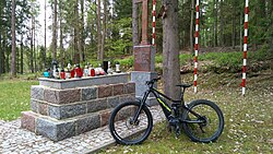
Kaliska, Kartuzy County
Kaliska | |
|---|---|
Village | |
 Memorial at the site of German massacres of Poles carried out in 1939 | |
| Coordinates: 54°20′10″N 18°13′59″E / 54.33611°N 18.23306°E | |
| Country | |
| Voivodeship | Pomeranian |
| County | Kartuzy |
| Gmina | Kartuzy |
| Population | 220 |
| Time zone | UTC+1 (CET) |
| • Summer (DST) | UTC+2 (CEST) |
| Vehicle registration | GKA |
Kaliska [kaˈliska] is a village in the administrative district of Gmina Kartuzy, within Kartuzy County, Pomeranian Voivodeship, in northern Poland.[1] It lies approximately 3 kilometres (2 mi) east of Kartuzy and 27 km (17 mi) west of the regional capital Gdańsk. It is located within the ethnocultural region of Kashubia in the historic region of Pomerania.
During the German occupation of Poland (World War II), the Kaliska forest was the site of large massacres of Poles, carried out by the Germans from September to November 1939 as part of the Intelligenzaktion.[2] Among the victims were Polish teachers, policemen, activists, local officials, dentists, postal workers, foresters, priests, and other inhabitants from Kartuzy, Żukowo and various nearby villages.[2]
References[edit]
- ^ "Central Statistical Office (GUS) - TERYT (National Register of Territorial Land Apportionment Journal)" (in Polish). 2008-06-01.
- ^ a b Wardzyńska, Maria (2009). Był rok 1939. Operacja niemieckiej policji bezpieczeństwa w Polsce. Intelligenzaktion (in Polish). Warsaw: IPN. pp. 107, 154.


