
Jumla District
This article needs additional citations for verification. (March 2008) |
Jumla District
जुम्ला जिल्ला | |
|---|---|
 Aerial view of Sinja Valley | |
| Nickname: Jumlanepal | |
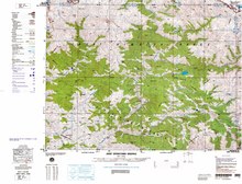
 Location of Jumla District (dark yellow) in Karnali Province of Nepal. | |
| Coordinates: 29°16′31″N 82°11′00″E / 29.275278°N 82.183333°E | |
| Country | |
| Province | Karnali Province |
| Admin HQ. | Jumla |
| Municipality | |
| Government | |
| • Type | Coordination committee |
| • Body | DCC, Jumla |
| • Parliamentary constituencies | 1 seats List |
| • Provincial constituencies | 2 seats List |
| Area | |
| • Total | 2,531 km2 (977 sq mi) |
| Highest elevation | 4,679 m (15,351 ft) |
| Lowest elevation | 915 m (3,002 ft) |
| Population (2011)[2] | |
| • Total | 108,921 |
| • Density | 43/km2 (110/sq mi) |
| Demographics | |
| • Ethnic groups | Chetri, Bahun, Thakuri |
| • Female ♀ | 50% |
| Human Development Index | |
| • Literacy | 55% |
| Time zone | UTC+05:45 (NPT) |
| Postal Codes | 21200, 21202, 21204, 21205..., 21209 |
| Telephone Code | 087 |
| Main Language(s) | Nepali |
| Major highways | Karnali |
| Website | daojumla.moha.gov.np ddcjumla.gov.np |

Jumla District (Nepali: जुम्ला जिल्लाⓘ), is one of the ten districts of the Karnali province of Nepal. This district has Jumla as its headquarters, an area of 2,531 square kilometres (977 sq mi); it had populations of 89,427 and 108,921, respectively, in the national censuses of 2001 and 2011.[3] Its territory lies between longitudes 81⁰ 28' and 82⁰ 18' East, and between latitudes 28⁰ 58' and 29⁰ 30' North.[4]

The Nepali language (then known as Khas language) originated in the Sinja Valley. Sinja was the capital of Khas Kingdom, and the dialect called "Khas Bhasa" is still spoken among that region's people.[5]
History[edit]
Khasa Kingdom[edit]
Jumla was a part of Khasa kingdom during the 11th to 13th century. After 13th-century, Khasa Kingdom collapsed and divided into Baise Rajya (22 principalities) in the Karnali-Bheri region and the Kingdom of Jumla was one of them.
Kingdom of Jumla[edit]
The Jumla Kingdom was one of the many kingdoms that dotted Nepal before its reunification by King Prithvi Narayan Shah of Gorkha and later by his younger son Bahadur Shah. The kingdom was founded around 1404 when Baliraja, who married the daughter of the last ruler of the Yatse (Malla) Kingdom, succeeded his father-in-law.[6] It was one of the most powerful kingdoms in western Nepal, being one of the 22 Baise principalities of the Karnali region which had once been part of the larger Yatse Kingdom. After centuries of intermittent warfare, it appropriated the kingdom of Mustang in 1760.[7] In the late 18th century the Jumla kingdom successfully defended itself against the first attack by King Prithivi Narayan Shah, and legend even has it that he got injured in the battle. Later, with the help of the kingdoms surrounding Jumla, Bahadur Shah attacked again and annexed Jumla for the Gorkha kings in 1789.[8] The Jumla kings were Thakuris (Sijapati, Malla, Shahi) like the Gorkha Kings.
The Jumla Kingdom belonged to the more extensive pre-unification kingdoms in Nepal. At the height of its power it extended from Mustang in the east to present-day Uttarakhand, a state in modern-day India, territory that the Kingdom of Nepal lost to the East India Company in 1816 during the partition of Nepal.[9] The Jumla kings belonged to the Kalyal dynasty, linked to the Mewar clan of Rajasthan, India. There have also been marriages between the Jumla royal family and the Shah's royal family of Nepal. The direct descendants of the erstwhile Jumla royal family include Nepali Film legend Nir Shah, Maya Kumar Shah SP (Retd.) of Nepal Police, former Director-General of Nepal Electricity Authority Harish Chandra Shah, DIGP (Retd) Sher Bahadur Shah, Colonel Nepal Army (Retd.) Bhim Bahadur Shah and AIGP (Retd.) of Nepal Police, Surendra Bahadur Shah.
Kings of Jumla[edit]
The kings of Jumla, post-1400:[10]
- Baliraja 1404-1445
- Vaksaraja 1445-? (son)
- Vijayaraja (son)
- Visesaraja fl. 1498 (son)
- Vibhogaraja (?)
- Matiraja (?)
- Sahiraja (?)
- Bhanasahi c. 1529-90 (son)
- Saimalsahi c. 1590-1599 (son)
- Vasantaraja 1599-1602 (son)
- Visekaraja 1599-1602 (brother)
- Vikramasahi 1602-c. 1635 (brother)
- Bahadurasahi c. 1635-65 (son)
- Virabhadrasahi 1665-after 1704
- Prithvipatisahi after 1704-1719 (son)
- Surathasahi 1719-1740 (son)
- Sudarasanasahi 1740-c. 1758 (son)
- Suryabhanasahi c. 1758-1789 (son)
Geography and climate[edit]
Geographically, Jumla is a Himalayan mountainous region of which elevations ranges from 915 metres (3,002 ft) to 4,679 metres (15,351 ft). The Higher Himalayan Region consists of Patarasi and Kanjirowa Himalayan ranges. The major rivers in Jumla are Hima, Tila and Jawa.[4]
| Climate Zone[11] | Elevation Range | % of Area |
|---|---|---|
| Temperate | 2,000 to 3,000 meters 6,400 to 9,800 ft. |
25.3% |
| Subalpine | 3,000 to 4,000 meters 9,800 to 13,100 ft. |
49.7% |
| Alpine | 4,000 to 5,000 meters 13,100 to 16,400 ft. |
13.9% |
| Nival | above 5,000 meters | 7.3% |
| Trans-Himalayan | 3,000 to 6,400 meters 9,800 to 21,000 ft. |
3.8% |
Demographics[edit]
At the time of the 2011 Nepal census, Jumla District had a population of 108,921.
As first language, 98.8% spoke Nepali, 0.6% Tamang, 0.3% Sherpa and 0.1% other languages.[12]
Ethnicity/caste: 60.4% were Chhetri, 10.9% Hill Brahmin, 7.4% Kami, 7.4% Thakuri, 7.1% Sarki, 2.5% Damai/Dholi, 1.1% Sanyasi/Dasnami, 1.1% Tamang, 0.9% Lohar, 0.2% Gharti/Bhujel, 0.2% Newar, 0.1% Bhote, 0.1% Gurung, 0.1% Magar, 0.1% Musalman, 0.1% Thakali and 0.2% others.[13]
Religion: 97.9% were Hindu, 1.2% Buddhist, 0.7% Christian, 0.1% Muslim and 0.1% others.[14]
Literacy: 54.0% could read and write, 3.4% could only read and 42.5% could neither read nor write.[15]
| Census year | Pop. | ±% p.a. | ||
|---|---|---|---|---|
| 1981 | 68,797 | — | ||
| 1991 | 75,964 | +1.00% | ||
| 2001 | 89,427 | +1.65% | ||
| 2011 | 108,921 | +1.99% | ||
| 2021 | 119,377 | +0.92% | ||
| ||||
| Source: Citypopulation[16] | ||||
Divisions[edit]
On 10 March 2017 Government of Nepal restricted old administrative structures and announced 744 new local level units (9 added later) as per the new constitution of Nepal 2015,[17]
According to new structure Jumla district is divided into 1 municipality (urban) and 7 rural municipality:
Municipalities[edit]
- Chandannath (UM)
- Kankasundari (RM)
- Sinja (RM)
- Hima (RM)
- Tila (RM)
- Guthichaur (RM)
- Tatopani (RM)
- Patarasi (RM)
Note: UM=Urban Municipality, RM=Rural Municipality
Ethno Medicine[edit]
Jumla along with Humla, Dolpa and Mustang districts have a history of people using traditional plants for medicine. Research has shown there are up to 109 different species of Ethnomedicine in these areas.[18]
Ethno Veterinary Medicine[edit]
Fifteen different species of plants are known to be used in ethno-veterinary practices in Jumla.[19]
Health[edit]
A 2019 study on blood types of people in Jumla revealed A positive is the most common blood type while B positive was the most requested from the blood bank at Karnali Academy of Health Sciences. It also states the most frequent demand for blood came from the gynecological department.[20]
A study on Health facility preparedness of maternal and neonatal health services in 2021 found that Health facilities have better staffing levels, have access to essential medicines and provision of ambulance transport of women and children.[21]
Women of Jumla[edit]
As part of research on the leading causes of death among Nepali women of child-bearing age, a study on Mental Health and Suicide among women in Jumla has found that there are six issues when it comes to women's lives and views on suicide: mental health issues; economics; education; domestic issues; differential gender impacts; suicide and thoughts about it.[22]
A study aimed at finding the frequency of teenage pregnancy and its outcomes revealed that it was 22% among total deliveries and that maternal complication accounted for 33% of the total pregnancies.[23] Awareness about teenage pregnancy is low.[24]
Women of Jumla were one of the first to be recruited into the Maoist Insurgency.[25]
Child marriage is prevalent in Jumla as of 2019.[citation needed]
64.4% of women in Jumla are illiterate.[26]
Lagi-Lagitya[edit]
An "inter-caste economic dependency in a long-term hereditary contractual labor relations" is called Lagi-Lagitya. The castes of Bahun, Thakuri, Chettri who own land but don't till themselves employ low caste groups of Kami and Sarki to work on their lands.[27]
Natural Resources[edit]
Jumla is rich in Non Timber Forest Products (NTFP) namely medicinal plants and aromatics. 41% of the district is covered with Forest and rangeland.[28]
Animals and Crops[edit]
The Himalayan Black Bear damages crops and attacks livestocks but locals support the animal's conservation.[29]
The red panda (Ailurus fulgens), a threatened carnivore species is found in Jumla.[30]
Rice Cultivation[edit]
Jumli Marshi is a high altitude rice variety that is thought to have been cultivated in Jumla since 1300 years ago.[31]
See also[edit]
Gallery[edit]
-
 Narakot Sinja Valley
 -
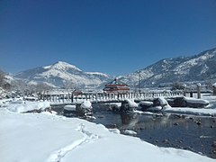 Beauty of Winter in Jumla
 -
 Tila Valley Jumla
 -
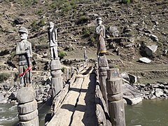 Wooden Craft, Jumla, Sinja
 -
 Way to Jumla
 -
 Jumla Panorama


References[edit]
- ^ "District Administration Office Jumla".
- ^ General Bureau of Statistics, Kathmandu, Nepal, November 2012
- ^ Districts of Nepal
- ^ a b "District profile of Jumla". Archived from the original on 2019-06-17. Retrieved 2018-08-01.
- ^ The origin of Nepali language is Sinja of Jumla, retrieved Feb 25, 2018
- ^ Ram Niwas Pandey (1998) The making of modern Nepal: A study of history, art, the culture of Western Nepal. Nirala Press.
- ^ Rishikesh Shaha (1997) Ancient and medieval Nepal. New Delhi: Manohar, p. 67.
- ^ Rishikesh Shaha (1996) Modern Nepal: A political history 1769-1955, Vol. I. New Delhi: Manohar, p. 53.
- ^ Rishikesh Shaha (1996) Modern Nepal: A political history 1769-1955, Vol. I. New Delhi: Manohar, p. 139.
- ^ Ram Niwas Pandey (1998) The making of modern Nepal: A study of history, art, culture of Western Nepal. Nirala Press.
- ^ The Map of Potential Vegetation of Nepal - a forestry/agroecological/biodiversity classification system (PDF), Forest & Landscape Development and Environment Series 2-2005 and CFC-TIS Document Series No.110., 2005, ISBN 87-7903-210-9, retrieved Nov 22, 2013
- ^ NepalMap Language
- ^ NepalMap Caste
- ^ NepalMap Religion
- ^ NepalMap Literacy
- ^ "NEPAL: Administrative Division". www.citypopulation.de.
- ^ "New local level structure comes into effect from today". www.thehimalayantimes.com. The Himalayan Times. 10 March 2017. Retrieved 17 July 2018.
- ^ Kunwar, R. M.; Nepal, B. K.; Kshhetri, H. B.; Rai, S. K.; Bussmann, R. W. (2022-06-27). "Ethnomedicine in Himalaya: a case study from Dolpa, Humla, Jumla and Mustang districts of Nepal | Journal of Ethnobiology and Ethnomedicine | Full Text". Journal of Ethnobiology and Ethnomedicine. 2: 27. doi:10.1186/1746-4269-2-27. PMC 1513199. PMID 16749924.
- ^ "STUDY ON ETHNO VETERINARY PRACTICES IN JUMLA".
- ^ "Blood Bank Service: An Experience at Karnali Academy of Health Sciences, Jumla, Nepal | MedS Alliance Journal of Medicine and Medical Sciences". 2022-08-02. Archived from the original on 2022-08-02. Retrieved 2022-11-29.
- ^ Tamang, Pasang; Simkhada, Padam; Bissell, Paul; van Teijlingen, Edwin; Khatri, Rose; Stephenson, John (2021-09-28). "Health facility preparedness of maternal and neonatal health services: a survey in Jumla, Nepal". BMC Health Services Research. 21 (1): 1023. doi:10.1186/s12913-021-07054-3. ISSN 1472-6963. PMC 8479916. PMID 34583697.
- ^ "ETD | Mental Health and Suicide Among Women in Jumla, Nepal: A Qualitative Exploration | ID: fn106z914 | Emory Theses and Dissertations". 2022-11-29. Archived from the original on 2022-11-29. Retrieved 2022-11-29.
- ^ "Adolescent Pregnancy and its Outcome in a Rural Teaching Hospital, Karnali Academy of Health Science, Jumla | Journal of Karnali Academy of Health Sciences". 2019-09-25. Archived from the original on 2019-09-25. Retrieved 2022-11-29.
- ^ Shrestha, Sharmila; Shrestha, Sarita; Lama, Monika; Ojha, Sujata; Thapa, Savina (2021). "Awareness and Attitude Regarding Teenage Pregnancy among Adolescent Girls of Chandannath Municipality, Jumla". Nepal Journal of Obstetrics and Gynaecology. 16 (2): 74–78. doi:10.3126/njog.v16i2.42106. ISSN 1999-8546. S2CID 249253674.
- ^ "Women's Participation in the People's War in Jumla" (PDF). 2022-09-21. Archived from the original (PDF) on 2022-09-21. Retrieved 2022-11-29.
- ^ Chaulagain, M.; Upadhyay, R.; Kanda, K.; Rawal, L. B.; Tiwari, S. K.; Devkota, B. S. (2004). "Women's Educational Status and Meternal and Child health Care Practices in Jumala Districts West Nepal". Journal of Nepal Health Research Council. doi:10.33314/jnhrc.v0i0.80 (inactive 31 January 2024). ISSN 1999-6217.
{{cite journal}}: CS1 maint: DOI inactive as of January 2024 (link) - ^ "NOTES ON LAGI-LAGITYA RELATIO S IN JUMLA". 2022-11-29. Archived from the original on 2022-11-29. Retrieved 2022-11-29.
- ^ Paudel, Mohan (2007). "Non-timber forest products from community forestry practices, problems and prospects for livelihood strategy in Jumla". Banko Janakari. 17 (2): 45–54. doi:10.3126/banko.v17i2.2155. ISSN 2631-2301.
- ^ "Europe PMC". 2022-11-29. Archived from the original on 2022-11-29. Retrieved 2022-11-29.
{{cite web}}: CS1 maint: bot: original URL status unknown (link) - ^ Shrestha, Saroj; Thapa, Arjun; Bista, Damber; Robinson, Natasha; Sherpa, Ang Phuri; Acharya, Krishna Prasad; Jnawali, Shant Raj; Lama, Sonam Tashi; Lama, Sony (May 2021). "Distribution and habitat attributes associated with the Himalayan red panda in the westernmost distribution range". Ecology and Evolution. 11 (9): 4023–4034. doi:10.1002/ece3.7297. ISSN 2045-7758. PMC 8093741. PMID 33976791.
- ^ Paudel, M. N. (2011). "Rice (Oryza sativa L) cultivation in the highest elevation of the world". Agronomy Journal of Nepal. 2: 31–41. doi:10.3126/ajn.v2i0.7519. ISSN 2091-0649.
External links[edit]
Headquarter: Jumla | ||
| Municipalities: 1 | | |
| Rural municipalities: 7 | ||
List of municipalities and rural municipalities of Nepal | ||
| International | |
|---|---|
| National | |