
Horsham St Faith and Newton St Faith
| Horsham St Faith and Newton St Faith | |
|---|---|
.JPG) The ford on the River Hor in the village | |
 Horsham St Faith and Newton St Faith Location within Norfolk | |
| Area | 7.33 km2 (2.83 sq mi) |
| Population | 1,724 (2011)[1] |
| • Density | 235/km2 (610/sq mi) |
| OS grid reference | TG216149 |
| Civil parish |
|
| District | |
| Shire county | |
| Region | |
| Country | England |
| Sovereign state | United Kingdom |
| Post town | NORWICH |
| Postcode district | NR10 |
| Police | Norfolk |
| Fire | Norfolk |
| Ambulance | East of England |
Horsham St Faith and Newton St Faith is a civil parish in the English county of Norfolk, consisting of the former parishes of Horsham St Faith and Newton St Faith. Collectively they are known as St Faiths. It covers an area of 7.33 km2 (2.83 sq mi) and had a population of 1,624 in 770 households at the 2001 census,[2] increasing to a population of 1,724 in 797 households at the 2011 Census. For the purposes of local government, it falls within the district of Broadland.
Horsham St Faith[edit]
.JPG)
The village takes its name from the River Hor, which flows through the parish on its course from Horsford to Horstead; and a Benedictine priory, founded in honour of St. Faith that, until the dissolution of the monasteries, stood there.[3]
Norwich International Airport, which was first developed in 1939 as RAF Horsham St. Faith is close by.[4]
The village is home to the City of Norwich Aviation Museum.
The remains of a motte and bailey castle, on the Horsford side of the A140, can reached by following a track to the north of Church Street, which joins Horsford and Horsham St Faith.
On 17 October in the early 12th century until 1872 it played host to one of the country's largest cattle fairs. This fair was held to the south of Spixworth Road around Bullock Hill and Calf Lane.[5]
In 1894 John Thomas Spurrell, the younger son of Richard James Spurrell of Thurgarton House, inherited several thousand acres in the parish from Barbara, Countess von Rechberg (daughter of Thomas Jones, 6th Viscount Ranelagh, and the estranged wife of the Austrian statesman Count Johann Bernhard von Rechberg und Rothenlöwen). He built the manor house in the 1920s. In the 1930s part of the estate was requisitioned for the construction of the RAF airbase.
The Church of St Mary and St Andrew[edit]

The present day church dates back to the 13th century and has undergone many changes. Much of the building was restored in 1873 with a £1400 donation from the Twinings tea family. Of interest inside the church is the rood screen, dated 1528 and adorned with 12 panels depicting saints, and the elaborate Jacobean font cover.[6] The reredos was erected in 1929 by John and Violet Spurrell in memory of their only son, John Francis Brabazon Spurrell, who was killed by buffalo at Kibaya, Tanganyika, in 1927.
Amenities[edit]
Amenities in the locality include a community centre, primary school, doctor's surgery, two post offices– one serving each village, restaurant, and a small industrial estate. The village had two public houses; the Kings Head[7] and the Black Swan. The former ceased trading in 2009.[8]
Located in Manor Road, the St Faith, or Norwich and Norfolk crematorium, was established in 1937. Prior to this, the site was occupied by a Poor Law Union workhouse which was destroyed by fire in 1923.[9] The large chapel by J P Chaplin was completed in 1936 and finished in red and mauve brick.[10] The Commonwealth War Graves Commission placed a memorial plaque in the chapel listing 30 British service personnel who were cremated here in World War II.[11] Notable people cremated here include two Victoria Cross recipients:
- Lieutenant-Colonel Victor Buller Turner (1900–1972), whose ashes were later buried at Ditchingham.[12]
- Sergeant William Burman (1897–1974), whose ashes were later taken to Golders Green Crematorium.[12]
Notable residents[edit]
- St. Robert Southwell - Jesuit priest, poet and martyr.
Newton St Faith[edit]

The village of Newton St Faith lies approximately 1 mile (1.6 km) north of Horsham St Faith. Much of the parish is given over to agriculture. Residential development is concentrated along Newton Street.
This section needs expansion. You can help by adding to it. (June 2009) |
Public transport[edit]
Bus
Services through and close to the villages are provided by First Norfolk & Suffolk, Stagecoach in Norfolk and Sanders[13] connecting the parish to surrounding towns, villages and further afield.
Gallery[edit]
-
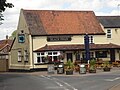
 The Kings Head public house (Closed 2009)
 -
 The Black Swan public house
 -
 The chapel at St Faith crematorium
 -
 The thatched roof bus shelter


Further reading[edit]
- Horsham and Newton St Faith (Towns and Villages)
- The Priory of Horsham St Faith
- Drayton and St Faith Medical Practice history.
- Information on the Parish Church of St Mary and St Andrew Horsham St Faith
Notes[edit]
This article includes a list of general references, but it lacks sufficient corresponding inline citations. (June 2009) |
- ^ "Civil Parish population 2011". Neighbourhood Statistics. Office for National Statistics. Retrieved 6 August 2016.
- ^ Census population and household counts for unparished urban areas and all parishes. Office for National Statistics & Norfolk County Council (2001). Retrieved 20 June 2009.
- ^ Priory history Retrieved 30 March. 2010
- ^ RAF Horsham St Faith Archived 23 June 2009 at the Wayback Machine Retrieved 18 December 2008
- ^ The cattle fairs Retrieved 4 March 2010
- ^ Norfolk churches Retrieved 18 March 2010
- ^ Norfolk pubs Retrieved 22 March 2010
- ^ st faiths village website The village website[permanent dead link] Retrieved 22 March 2010
- ^ Horsham and Newton St Faith Retrieved 23 March 2010
- ^ Pevsner, Nikolaus; Pevsner and Wilson (1997). Buildings of England: Norfolk 1: Norwich and North-East. Penguin. p. 568. ISBN 0-300-09607-0. Retrieved 26 March 2010
- ^ [1] CWGC Cemetery Report.
- ^ a b [2] Burial Locations Victoria Cross recipients - Norfolk county.
- ^ Sanders coaches Retrieved 27 March 2010