
Hoogmade
Hoogmade | |
|---|---|
Village | |
.JPG) View on Hoogmade | |
 Hoogmade Location in the province of South Holland in the Netherlands  Hoogmade Location in the Netherlands | |
| Coordinates: 52°10′N 4°35′E / 52.167°N 4.583°E | |
| Country | Netherlands |
| Province | South Holland |
| Municipality | Kaag en Braassem |
| Area | |
| • Total | 1.07 km2 (0.41 sq mi) |
| Elevation | −1.0 m (−3.3 ft) |
| Population (2021)[1] | |
| • Total | 1,460 |
| • Density | 1,400/km2 (3,500/sq mi) |
| Time zone | UTC+1 (CET) |
| • Summer (DST) | UTC+2 (CEST) |
| Postal code | 2355[1] |
| Dialing code | 071 |
| Major roads | A4 N446 |
Hoogmade is a village in the Dutch province of South Holland. It is located about 7 km east of Leiden, in the municipality of Kaag en Braassem.
History[edit]
The village was first mentioned between 1280 and 1287 as "Hoghe made", and means "elevated hay land".[3] Hoogmade is a peat excavation settlement which developed in the Middle Ages.[4]
The Dutch Reformed church is an aisleless church with open wooden tower built between 1729 and 1730 as a replacement of the medieval church. The Catholic Onze-Lieve-Vrouw-Geboorte church is an aisleless church with built-in tower with needle spire. It was built between 1931 and 1932 to replace the 1875 church which had collapsed.[4] On 4 November 2019, the Onze-Lieve-Vrouw-Geboorte church was severely damaged by fire.[5] With the help of many volunteers to raise money, three years after this fire the rebuilding of the church has started [6]
The polder mill Doesmolen was built around 1636. It was in service until 1953. In 1965, it was restored and functions on a voluntary basis.[7]
Hoogmade was home to 311 people in 1840.[8] It was a separate municipality between 1817 and 1855, when it merged with Woubrugge.[9] In 2009, it became part of the municipality of Kaag en Braassem.[8]
Gallery[edit]
-
 Canal view
 -
 Map of Hoogmade
 -
 The Does waterway, close to Hoogmade
 -
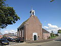 Dutch Reformed church


.JPG)

References[edit]
- ^ a b c "Kerncijfers wijken en buurten 2021". Central Bureau of Statistics. Retrieved 4 May 2022.
- ^ "Postcodetool for 2355AA". Actueel Hoogtebestand Nederland (in Dutch). Het Waterschapshuis. Retrieved 4 May 2022.
- ^ "Hoogmade - (geografische naam)". Etymologiebank (in Dutch). Retrieved 4 May 2022.
- ^ a b Ronald Stenvert & Sabine Broekhoven (2004). "Hoogmade" (in Dutch). Zwolle: Waanders. ISBN 90-400-9034-3. Retrieved 4 May 2022.
- ^ Pieters, Janene. "Videos: Church burns down in Zuid-Holland village; locals devastated". Netherlands Times. Retrieved 5 November 2019.
- ^ https://www.rodi.nl/alphenaandenrijn/nieuws/316459/drie-jaar-na-brand-wordt-de-olv-geboortekerk-in-hoogmade-herbouwd
- ^ "Doesmolen". Molen database (in Dutch). Retrieved 4 May 2022.
- ^ a b "Hoogmade". Plaatsengids (in Dutch). Retrieved 4 May 2022.
- ^ Ad van der Meer and Onno Boonstra, "Repertorium van Nederlandse gemeenten", KNAW, 2006. "KNAW > Publicaties > Detailpagina". Archived from the original on 20 February 2007. Retrieved 3 December 2009.