
Puerto Rico Highway 873
(Redirected from Highway 873 (Puerto Rico))
Highway 873 | ||||
|---|---|---|---|---|
| Ruta 873 | ||||
| Route information | ||||
| Maintained by Puerto Rico DTPW | ||||
| Length | 1.7 km[1] (1.1 mi) | |||
| Major junctions | ||||
| South end | ||||
| North end | ||||
| Location | ||||
| Country | United States | |||
| Territory | Puerto Rico | |||
| Municipalities | San Juan, Guaynabo | |||
| Highway system | ||||
| ||||

Puerto Rico Highway 873 (PR-873) is a north–south road located between the municipalities of San Juan and Guaynabo, Puerto Rico,[2] and it corresponds to an original segment of the historic Carretera Central.[3] The General Norzagaray Bridge is located on this route.[3]
-
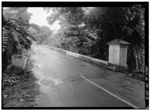 General Norzagaray Bridge looking south
 -
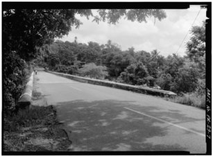 General Norzagaray Bridge looking north


Major intersections[edit]
| Municipality | Location | km[1] | mi | Destinations | Notes | |||
|---|---|---|---|---|---|---|---|---|
| San Juan | Tortugo | 1.7 | 1.1 | PR-1 | Southern terminus of PR-873; the Carretera Central continues toward Guaynabo; access to San Juan and Caguas; unsigned | |||
| Quebrada Frailes | 0.8– 0.7 | 0.50– 0.43 | Puente General Norzagaray[4] | |||||
| Guaynabo |
No major junctions | |||||||
| San Juan | Caimito | 0.0 | 0.0 | Northern terminus of PR-873; the Carretera Central continues toward San Juan; no access to PR-199 west; PR-1 north access is via PR-199 east; access to San Juan, Caguas and Trujillo Alto | ||||
| 1.000 mi = 1.609 km; 1.000 km = 0.621 mi | ||||||||
See also[edit]
References[edit]
- ^ a b Google (29 February 2020). "PR-873" (Map). Google Maps. Google. Retrieved 29 February 2020.
- ^ National Geographic Maps (2011). Puerto Rico (Map). 1:125,000. Adventure Map (Book 3107). Evergreen, Colorado: National Geographic Maps. ISBN 978-1566955188. OCLC 756511572.
- ^ a b Pumarada O'Neill, Luis (31 July 1994). "National Register of Historic Places Registration: General Norzagaray Bridge". National Park Service. Retrieved 10 June 2019. With photos from 1989 & 1993
- ^ Luis F. Pumarada O’Neill (1991). "Los Puentes Históricos de Puerto Rico" (PDF) (in Spanish). pp. 43–44. Retrieved 10 March 2020.
External links[edit]
 Media related to Puerto Rico Highway 873 at Wikimedia Commons
This Puerto Rico road-related article is a stub. You can help Wikipedia by expanding it. |