
Harrietta, Michigan
Harrietta, Michigan | |
|---|---|
| Village of Harrietta | |
.jpg) Looking south along Davis Avenue | |
 Location within Wexford County | |
 Harrietta Location within the state of Michigan  Harrietta Location within the United States | |
| Coordinates: 44°18′30″N 85°41′57″W / 44.30833°N 85.69917°W | |
| Country | |
| State | |
| County | Wexford |
| Townships | Boon and Slagle |
| Settled | 1889 |
| Incorporated | 1891 |
| Government | |
| • Type | Village council |
| • President | Keith Broughton |
| • Clerk | Mary Morisette |
| Area | |
| • Total | 0.99 sq mi (2.57 km2) |
| • Land | 0.99 sq mi (2.57 km2) |
| • Water | 0.00 sq mi (0.00 km2) |
| Elevation | 1,145 ft (349 m) |
| Population (2020) | |
| • Total | 151 |
| • Density | 152.06/sq mi (58.72/km2) |
| Time zone | UTC-5 (Eastern (EST)) |
| • Summer (DST) | UTC-4 (EDT) |
| ZIP code(s) | 49638 |
| Area code | 231 |
| FIPS code | 26-36720[2] |
| GNIS feature ID | 1620134[3] |
Harrietta is a village in Wexford County of the U.S. state of Michigan.[3] The population was 151 at the 2020 census, which ranked it as the eighth least-populated village in the state. The village is split almost evenly between Slagle Township on the west and Boon Township on the east.[4]
History[edit]
The community first platted in 1889 along the Toledo, Ann Arbor and North Michigan Railway. It was recorded with the spelling Harriette, which early founder James Ashley chose from combining his father's name of Harry and his fiancé Henriette Burt. The Springdale post office, which was established earlier to the north in 1874, moved to Harriette in 1890 but retained is original name. The community incorporated as a village in 1891 under the name Gaston, but railway executives insisted on returning the community to its original name of Harriette in 1892. The community and post office name was again changed to its current name of Harrietta in 1925.[5]
Geography[edit]
According to the U.S. Census Bureau, the village has a total area of 0.99 square miles (2.56 km2), all land.[6]
Demographics[edit]
| Census | Pop. | Note | %± |
|---|---|---|---|
| 1890 | 335 | — | |
| 1900 | 419 | 25.1% | |
| 1910 | 336 | −19.8% | |
| 1920 | 226 | −32.7% | |
| 1930 | 149 | −34.1% | |
| 1940 | 208 | 39.6% | |
| 1950 | 112 | −46.2% | |
| 1960 | 119 | 6.3% | |
| 1970 | 132 | 10.9% | |
| 1980 | 139 | 5.3% | |
| 1990 | 157 | 12.9% | |
| 2000 | 169 | 7.6% | |
| 2010 | 143 | −15.4% | |
| 2020 | 151 | 5.6% | |
| U.S. Decennial Census[7] | |||
2010 census[edit]
As of the census[8] of 2010, there were 143 people, 60 households, and 40 families residing in the village. The population density was 153.8 inhabitants per square mile (59.4/km2). There were 103 housing units at an average density of 110.8 per square mile (42.8/km2). The racial makeup of the village was 94.4% White, 0.7% African American, 0.7% Asian, and 4.2% from two or more races. Hispanic or Latino of any race were 4.2% of the population.
There were 60 households, of which 21.7% had children under the age of 18 living with them, 53.3% were married couples living together, 5.0% had a female householder with no husband present, 8.3% had a male householder with no wife present, and 33.3% were non-families. 26.7% of all households were made up of individuals, and 10% had someone living alone who was 65 years of age or older. The average household size was 2.38 and the average family size was 2.80.
The median age in the village was 46.1 years. 21% of residents were under the age of 18; 4.2% were between the ages of 18 and 24; 23.1% were from 25 to 44; 34.3% were from 45 to 64; and 17.5% were 65 years of age or older. The gender makeup of the village was 53.8% male and 46.2% female.
2000 census[edit]
As of the census[2] of 2000, there were 169 people, 63 households, and 43 families residing in the village. The population density was 182.0 inhabitants per square mile (70.3/km2). There were 93 housing units at an average density of 100.2 per square mile (38.7/km2). The racial makeup of the village was 98.22% White, 0.59% from other races, and 1.18% from two or more races. Hispanic or Latino of any race were 4.73% of the population.
There were 63 households, out of which 27.0% had children under the age of 18 living with them, 54.0% were married couples living together, 12.7% had a female householder with no husband present, and 30.2% were non-families. 23.8% of all households were made up of individuals, and 12.7% had someone living alone who was 65 years of age or older. The average household size was 2.68 and the average family size was 3.18.
In the village, the population was spread out, with 26.6% under the age of 18, 8.3% from 18 to 24, 28.4% from 25 to 44, 20.1% from 45 to 64, and 16.6% who were 65 years of age or older. The median age was 37 years. For every 100 females, there were 96.5 males. For every 100 females age 18 and over, there were 90.8 males.
The median income for a household in the village was $33,500, and the median income for a family was $34,286. Males had a median income of $28,125 versus $31,563 for females. The per capita income for the village was $15,258. About 4.8% of families and 6.9% of the population were below the poverty line, including 5.6% of those under the age of eighteen and none of those sixty-five or over.
Images[edit]
-
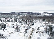 Aerial view in December 2017
 -
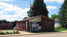 U.S. Post Office in Harrietta
 -
 Road signage along Slagle Street
 -
 Harrietta Village Hall


References[edit]
- ^ "2020 U.S. Gazetteer Files". United States Census Bureau. Retrieved May 21, 2022.
- ^ a b "U.S. Census website". United States Census Bureau. Retrieved January 31, 2008.
- ^ a b U.S. Geological Survey Geographic Names Information System: Henrietta, Michigan
- ^ "Michigan: 2010 Population and Housing Unit Counts 2010 Census of Population and Housing" (PDF). 2010 United States census. United States Census Bureau. September 2012. p. 45 Michigan. Archived (PDF) from the original on October 19, 2012. Retrieved January 30, 2022.
- ^ Romig, Walter (October 1, 1986) [1973]. Michigan Place Names: The History of the Founding and the Naming of More Than Five Thousand Past and Present Michigan Communities (Paperback). Detroit, Michigan: Wayne State University Press. p. 253. ISBN 978-0-8143-1838-6.
- ^ "2019 U.S. Gazetteer Files". United States Census Bureau. Retrieved July 25, 2020.
- ^ "Census of Population and Housing". Census.gov. Retrieved June 4, 2015.
- ^ "U.S. Census website". United States Census Bureau. Retrieved November 25, 2012.
Municipalities and communities of Wexford County, Michigan, United States | ||
|---|---|---|
| Cities |  | |
| Villages | ||
| Charter township | ||
| Civil townships | ||
| CDPs | ||
| Other communities | ||
| Ghost towns | ||
| Footnotes | ‡This populated place also has portions in an adjacent county or counties | |
| International | |
|---|---|
| National | |