
Gryfino
Gryfino | |
|---|---|
.jpg) Church of the Nativity of the Virgin Mary | |
 Flag  Coat of arms | |
 Gryfino | |
| Coordinates: 53°15′11″N 14°29′15″E / 53.25306°N 14.48750°E | |
| Country | |
| Voivodeship | West Pomeranian |
| County | Gryfino |
| Gmina | Gryfino |
| Government | |
| • Mayor | Mieczysław Sawaryn |
| Area | |
| • Total | 9.58 km2 (3.70 sq mi) |
| Population (2017) | |
| • Total | 21,393 |
| • Density | 2,200/km2 (5,800/sq mi) |
| Time zone | UTC+1 (CET) |
| • Summer (DST) | UTC+2 (CEST) |
| Postal code | 74-100 |
| Car plates | ZGR |
| National roads | |
| Voivodeship roads | |
| Website | www |
Gryfino [ɡrɨˈfʲinɔ] (German: Greifenhagen) is a town in Pomerania, northwestern Poland, with 21,393 inhabitants (2017). It is also the capital of Gryfino County in West Pomeranian Voivodeship.
The town is located on the Odra Wschodnia, the eastern branch of the Oder river, about 20 kilometres (12 miles) south of Szczecin in Poland. The western branch of the Oder, 2 km (1 mi) away from the town center, marks the border with Germany. There is a direct road link between Gryfino and the German town of Mescherin across the river.
The Crooked Forest is located in the village of Nowe Czarnowo, just outside Gryfino.
History[edit]

The territory became part of the emerging Polish state under Mieszko I around 967.[1] Following the fragmentation of Poland into smaller duchies it formed part of the Duchy of Pomerania. There are archaeological traces of Slavic settlement dating back to the 12th century.[2] The settlement was built in 1230,[3] and was raised to the rank of a town by Duke Barnim I in 1254.[2] In 1271 Barnim I granted guild privileges modelled after Szczecin.[4] In 1281 the town was exempted from customs duties and declared a free port.[4] In 1284 it obtained a permission to build defensive walls[2] and was one of the Pomeranian towns that guaranteed a peace treaty between the Duchy of Pomerania and the Margraviate of Brandenburg.[4] The town was in conflict with the town of Gartz across the Oder (current twin town), which was resolved in 1304.[5] In 1306 Duke Otto I allowed the town to build a bridge and a dam over the Oder and collect customs duties on it like Szczecin.[5]
In the Thirty Years' War, the town was hit by epidemics in 1625 and 1638, and was occupied by the Holy Roman Empire in 1627–1630 and by Sweden in 1630–1640.[2] After the war, it remained in Swedish possession. In 1675 it was captured by the Brandenburgers, into whose possession it came finally in 1679.[3] In 1709 Polish King Stanisław Leszczyński stopped in the town.[2] In 1723, French Huguenots settled in the town.[2] During the Seven Years' War, the town was plundered by the Russians.[2] From 1871 it formed part of the German Empire.
Two labour camps of the Reich Labour Service were located in the town under Nazi Germany.[6] In the final months of World War II, in March 1945, it was captured by Allied Polish and Russian forces.[7] Afterwards, the region became again part of Poland, although with a Soviet-installed communist regime, which stayed in power until the Fall of Communism in the 1980s. Despite the existence of the old Polish name Gryfów,[8] the town was first renamed to Gryfin,[9] and in 1946 to Gryfino by replacing the German suffix -hagen by the Polish suffix -ino.[10]
After the war, the town's life was reestablished, in 1945 the first schools began teaching, in 1946 the Gryf cinema was opened, and in 1947 the municipal library was opened.[2] A new hospital and culture center were opened in 1955 and 1958, respectively.[2] From 1975 to 1998 Gryfino was administratively located in the Szczecin Voivodeship. Underground anti-communist press was published in Gryfino from 1982 to 1984.[2] In 2021, a mural to Polish resistance hero Witold Pilecki was unveiled in Gryfino.[11]
Demographics[edit]
| Year | Pop. | ±% |
|---|---|---|
| 1724 | 1,807 | — |
| 1748 | 2,153 | +19.1% |
| 1794 | 2,627 | +22.0% |
| 1875 | 6,759 | +157.3% |
| 1890 | 6,692 | −1.0% |
| 1925 | 8,184 | +22.3% |
| 1939 | 9,855 | +20.4% |
| 1960 | 5,300 | −46.2% |
| 1970 | 7,400 | +39.6% |
| 1975 | 10,800 | +45.9% |
| 1980 | 15,300 | +41.7% |
| 1990 | 21,000 | +37.3% |
| 1995 | 22,100 | +5.2% |
| 2004 | 22,500 | +1.8% |
| Source: verwaltungsgeschichte.de[2] | ||
Sports[edit]
The main local sports team are handball team KPR Gryfino, which competes in the I liga (as of 2023–24),[12] and football team Energetyk Gryfino, which competes in the lower divisions. There are also various youth clubs dedicated to athletics, gymnastics,[13] swimming,[14] chess,[15] etc.
Transport[edit]
_Travelarz.JPG)
There is a railway station in the town, located on the significant Wrocław–Szczecin railway. Gryfino is located on the intersection of the national road 31 and voivodeship road 120.
International relations[edit]
Gryfino is twinned with:
Towns near Gryfino[edit]
- Szczecin (Poland)
- Stargard (Poland)
- Cedynia (Poland)
- Chojna (Poland)
- Mieszkowice (Poland)
- Moryń (Poland)
- Trzcińsko-Zdrój (Poland)
- Myślibórz (Poland)
- Pyrzyce (Poland)
- Schwedt (Germany)
- Vierraden (Germany)
- Gartz (Germany)
- Penkun (Germany)
Gallery[edit]
-
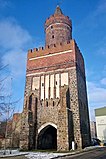 Bańska Gate
 -
 Town hall
 -
 A bridge on the Oder River in Gryfino
 -
 Medieval defensive walls
.jpg)

.jpg)

Notable people[edit]
- Michał Bieniek (born 1984 in Gryfino) a former Polish athlete who specialized in the high jump. He competed at the 2008 Summer Olympics
See also[edit]
- Crooked Forest, a nearby forest
References[edit]
- ^ Labuda, Gerard (1993). "Chrystianizacja Pomorza (X–XIII stulecie)". Studia Gdańskie (in Polish). Vol. IX. Gdańsk-Oliwa. p. 47.
- ^ a b c d e f g h i j k "Kalendarium". Gryfino.pl (in Polish). Retrieved 24 September 2023.
- ^ a b One or more of the preceding sentences incorporates text from a publication now in the public domain: Chisholm, Hugh, ed. (1911). "Greifenhagen". Encyclopædia Britannica. Vol. 12 (11th ed.). Cambridge University Press.
- ^ a b c Kratz, Gustav (1865). Die Städte der Provinz Pommern. Abriss ihrer Geschichte, zumeist nach Urkunden. Berlin. p. 181.
{{cite book}}: CS1 maint: location missing publisher (link) - ^ a b Kratz, p. 182
- ^ "V Pommern-West" (in German). Retrieved 24 September 2023.
- ^ Marian Anklewicz. "70 lat temu w Gryfinie. Początek walk o Gryfino". igryfino.pl (in Polish). Retrieved 24 September 2023.
- ^ Leksykon Polactwa w Niemczech (in Polish). Opole: Związek Polaków w Niemczech. 1939. p. 269.
- ^ Wojskowy Instytut Geograficzny Sztabu Generalnego W.P. (1945). "Mapa Polski" (Map). Mapa Polski. 1:1,000,000 (in Polish).
- ^ Manfred Niemeyer (2012). Deutsches Ortsnamenbuch. Walter de Gruyter GmbH & Co KG. p. 219.
- ^ "Gryfino: Odsłonięto mural przedstawiający Witolda Pileckiego". Szczecińskie24.pl (in Polish). Retrieved 24 September 2023.
- ^ "KPR Gryfino – Oficjalna strona klubu" (in Polish). Retrieved 24 September 2023.
- ^ "Międzyszkolny Klub Sportowy "HERMES" - strona oficjalna" (in Polish). Retrieved 24 September 2023.
- ^ "UKP MARLIN" (in Polish). Retrieved 24 September 2023.
- ^ "UKS Biały Pion Gryfino" (in Polish). Retrieved 24 September 2023.
External links[edit]
- Official website
- Jewish Community in Gryfino on Virtual Shtetl
Seat: Gryfino | ||
| Urban-rural gminas |  | |
| Rural gminas | ||

| International | |
|---|---|
| National | |