
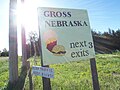
Gross, Nebraska
Gross, Nebraska | |
|---|---|
 Downtown Gross | |
 Location of Gross, Nebraska | |
| Coordinates: 42°56′46″N 98°34′11″W / 42.94611°N 98.56972°W | |
| Country | United States |
| State | Nebraska |
| County | Boyd |
| Area | |
| • Total | 0.13 sq mi (0.33 km2) |
| • Land | 0.13 sq mi (0.33 km2) |
| • Water | 0.00 sq mi (0.00 km2) |
| Elevation | 1,768 ft (539 m) |
| Population (2020) | |
| • Total | 3 |
| • Density | 23.44/sq mi (9.05/km2) |
| Time zone | UTC-6 (Central (CST)) |
| • Summer (DST) | UTC-5 (CDT) |
| ZIP code | 68719[3] |
| Area code(s) | 402 and 531 |
| FIPS code | 31-20295 |
| GNIS feature ID | 2398211[2] |
Gross is a village in Boyd County, Nebraska, United States. As of the 2020 census,[4] the village had a total population of 3. In the 2000 United States Census, it was one of only eight places with a population of five people. The others were Storrie, California; Bear Head Lake, Minnesota; Baker, Missouri; Odell, New Hampshire; Maza, North Dakota; Somerset, Vermont, and Prudhoe Bay, Alaska.
History[edit]
Gross was founded in 1893.[5] It was named for Ben Gross, who kept a general store.[6]
Geography[edit]
According to the United States Census Bureau, the village has a total area of 0.13 square miles (0.34 km2), all land.[7]
Demographics[edit]
| Census | Pop. | Note | %± |
|---|---|---|---|
| 1900 | 325 | — | |
| 1910 | 111 | −65.8% | |
| 1920 | 84 | −24.3% | |
| 1930 | 51 | −39.3% | |
| 1940 | 23 | −54.9% | |
| 1950 | 29 | 26.1% | |
| 1960 | 17 | −41.4% | |
| 1970 | 8 | −52.9% | |
| 1980 | 2 | −75.0% | |
| 1990 | 7 | 250.0% | |
| 2000 | 5 | −28.6% | |
| 2010 | 2 | −60.0% | |
| 2020 | 3 | 50.0% | |
| U.S. Decennial Census[8] 2012 Estimate[9] | |||
2010 census[edit]
As of the census[10] of 2010, there were 2 people, 1 household, and 1 family residing in the village. The population density was 15.4 inhabitants per square mile (5.9/km2). There were 4 housing units at an average density of 30.8 per square mile (11.9/km2). The racial makeup of the village was 100.0% White.
There was 1 household of which 100.0% were married couples living together. 0.0% of households were made up of individuals. The average household size was 2.00 and the average family size was 2.00.
The median age in the village was 49 years. 0.0% of residents were under the age of 18; 0.0% were between the ages of 18 and 24; 0.0% were from 25 to 44; 100% were from 45 to 64; and 0.0% were 65 or older. The gender makeup of the village was 50.0% male and 50.0% female.
2000 census[edit]
As of the census[11] of 2000, there were 5 people, 1 household, and 1 family residing in the village. The population density was 38.3 inhabitants per square mile (14.8/km2). There was 1 housing unit at an average density of 7.7 per square mile (3.0/km2). The racial makeup of the village was 100.00% White.
There was 1 household, of which 100.0% were married couple living together, with children under the age of 18 living with them. Consequently, the average household size and the average family size was 5.00.
The age distribution was 20.0% under 18, 40.0% from 18 to 24, 20.0% from 25 to 44, 20.0% from 45 to 64, and 0.0% over 64 years of age. The median age was 22 years. For every 100 females there were 150.0 males. For every 100 females age 18 and over, there were 100.0 males.
CNN profile[edit]
The town was the subject of a profile on CNN in November 2018 when, to mark that year's Thanksgiving, Gross' two inhabitants hosted a family reunion that briefly swelled its population to 20.[12]
-
-

-
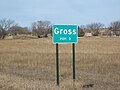 Sign listing the population as 3


Education[edit]
Gross is in Boyd County Schools,[13] established in June 2017.[14]
Gross was formerly in West Boyd Public Schools,[15] which was established in a merger in July 2007.[16]
References[edit]
- ^ "ArcGIS REST Services Directory". United States Census Bureau. Retrieved September 18, 2022.
- ^ a b U.S. Geological Survey Geographic Names Information System: Gross, Nebraska
- ^ "Gross NE ZIP Code". zipdatamaps.com. 2024. Retrieved February 5, 2024.
- ^ "Explore Census Data". data.census.gov. Retrieved 2024-03-25.
- ^ "Gross, Boyd County". Center for Advanced Land Management Information Technologies. University of Nebraska. Retrieved 30 July 2014.
- ^ "12 U.S. places where your visit could double the population". Mother Nature Network. Retrieved 2 May 2014.
- ^ "US Gazetteer files 2010". United States Census Bureau. Archived from the original on 2012-01-25. Retrieved 2012-06-24.
- ^ United States Census Bureau. "Census of Population and Housing". Retrieved June 23, 2013.
- ^ "Annual Estimates of the Resident Population: April 1, 2010 to July 1, 2012". Archived from the original on October 19, 2013. Retrieved June 23, 2013.
- ^ "U.S. Census website". United States Census Bureau. Retrieved 2012-06-24.
- ^ "U.S. Census website". United States Census Bureau. Retrieved 2008-01-31.
- ^ Kent, Lauren (November 22, 2018). "This Nebraska town -- population 2 -- grew to 10 times its size for a Thanksgiving feast". CNN.com. Retrieved November 22, 2018.
- ^ "2020 CENSUS - SCHOOL DISTRICT REFERENCE MAP: Boyd County, NE" (PDF). U.S. Census Bureau. Archived (PDF) from the original on 2021-04-17. Retrieved 2021-04-17.
- ^ "Boyd County Schools". Nebraska Department of Education. Retrieved 2021-04-20.
- ^ "SCHOOL DISTRICT REFERENCE MAP (2010 CENSUS): Boyd County, NE" (PDF). U.S. Census Bureau. Retrieved 2021-04-17.
- ^ "WEST BOYD SCHOOL DISTRICT". Nebraska Department of Education. Retrieved 2021-04-20.
Municipalities and communities of Boyd County, Nebraska, United States | ||
|---|---|---|
| Villages |  | |
| Townships | ||
| Ghost towns | ||
| International | |
|---|---|
| National | |