
File:Wutach w-o-GeoSchnitt.jpg
Size of this preview: 799 × 225 pixels. Other resolutions: 320 × 90 pixels | 640 × 180 pixels | 1,800 × 507 pixels.
Original file (1,800 × 507 pixels, file size: 425 KB, MIME type: image/jpeg)
| This is a file from the Wikimedia Commons. Information from its description page there is shown below. Commons is a freely licensed media file repository. You can help. |
| Description |
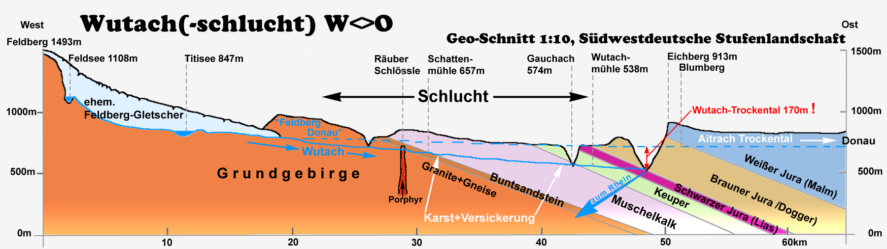
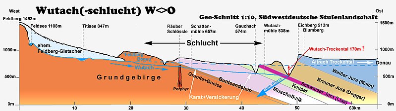
English: Schematic overview of the outcrops of all geological strata in south west Germany. The enormous holocene erosion of the Wutach River is a most prominent example for geology in situ.
Deutsch: Geologisches Profil (west-ost) des Südwestdeutschen Schichtstufenlandes endlang der oberen Wutach mit Kennzeichnung des Verlaufs der so genannten „Feldbergdonau". Hohe Reliefenergie im Holozän schuf zahlreiche Aufschlüsse der Gesteinsschichten. Erstklassiges Anschaungsmaterial für die Geologie: Die Wutachschlucht schneidet auf nur 20km alle geologischen Schichten Südwestdeutschlands an und macht sie sichtbar. |
| Date | |
| Source | image by author; based on material from „Regierungspräsidium Freiburg, Ref. 56, Naturschutz + Landschaftspflege" |
| Author | Ustill |
This file is licensed under the Creative Commons Attribution-Share Alike 2.0 Germany license.
- You are free:
- to share – to copy, distribute and transmit the work
- to remix – to adapt the work
- Under the following conditions:
- attribution – You must give appropriate credit, provide a link to the license, and indicate if changes were made. You may do so in any reasonable manner, but not in any way that suggests the licensor endorses you or your use.
- share alike – If you remix, transform, or build upon the material, you must distribute your contributions under the same or compatible license as the original.

File history
Click on a date/time to view the file as it appeared at that time.
| Date/Time | Thumbnail | Dimensions | User | Comment | |
|---|---|---|---|---|---|
| current | 16:16, 26 March 2016 | 1,800 × 507 (425 KB) | Ustill | Schreibfehler korrigiert | |
| 00:00, 17 May 2008 | 1,800 × 507 (422 KB) | Ustill | {{Information| |Description= {{en| Schematic overview of the outcrops of all geological strata in south west Germany. The enormous holocene erosion of the Wutach River is a most prominent example for geology in situ.} |
File usage
The following pages on the English Wikipedia use this file (pages on other projects are not listed):
Global file usage
The following other wikis use this file:
- Usage on als.wikipedia.org
- Usage on de.wikipedia.org
- Usage on fr.wikipedia.org