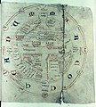
File:World map intermediate between T-O and mappa mundi.jpg

Page contents not supported in other languages.
This is a file from the Wikimedia Commons
From Wikipedia, the free encyclopedia

Original file(3,473 × 3,696 pixels, file size: 4.17 MB, MIME type: image/jpeg)

Summary

Description
English: Map with its centre Delos, following a Greek tradition; the compass-drawn circle is the Cyclades, in French manuscript of Henry of Huntingdon, Ymago Mundi. The Mare Occeanum is a necklace of red and blue uncials. In this orientation, Asia is at the top, Africa bottom right and Europe bottom left. Shelfmark: MS. e Mus. 223, fol. 185r
Date late 13th century
Source The Bodleian Libraries, Oxford
Creator
Henry of Huntingdon
Permission
(Reusing this file)

This is a faithful photographic reproduction of an original two-dimensional work of art. The work of art itself is in the public domain for the following reason:

Public domain

This work is in the public domain in its country of origin and other countries and areas where the copyright term is the author's life plus 100 years or fewer.


You must also include a United States public domain tag to indicate why this work is in the public domain in the United States.

This digital reproduction has been released under the following licenses:

w:en:Creative Commons
attribution
This file is licensed under the Creative Commons Attribution 4.0 International license.
You are free:
  • to share – to copy, distribute and transmit the work
  • to remix – to adapt the work
Under the following conditions:
  • attribution – You must give appropriate credit, provide a link to the license, and indicate if changes were made. You may do so in any reasonable manner, but not in any way that suggests the licensor endorses you or your use.

In many jurisdictions, faithful reproductions of two-dimensional public domain works of art are not copyrightable. The Wikimedia Foundation's position is that these works are not copyrightable in the United States (see Commons:Reuse of PD-Art photographs). In these jurisdictions, this work is actually in the public domain and the requirements of the digital reproduction's license are not compulsory.

Georeferencing Georeference the map in Wikimaps Warper If inappropriate please set warp_status = skip to hide.
 Archival data
The Bodleian Libraries, Oxford


This file comes from the Bodleian Libraries, a group of research libraries in Oxford University.
This tag does not indicate the copyright status of the attached work. A normal copyright tag is still required. See Commons:Licensing.

Captions

Add a one-line explanation of what this file represents

Items portrayed in this file

depicts

File history

Click on a date/time to view the file as it appeared at that time.

Date/TimeThumbnailDimensionsUserComment
current06:30, 5 September 2022Thumbnail for version as of 06:30, 5 September 20223,473 × 3,696 (4.17 MB)Mike Krügerhigher resolution
19:31, 8 September 2018Thumbnail for version as of 19:31, 8 September 2018657 × 730 (181 KB)User-duckCropped using CropTool with lossless mode.
18:17, 30 July 2015Thumbnail for version as of 18:17, 30 July 2015675 × 1,000 (209 KB)MartinPoulterUser created page with UploadWizard
The following pages on the English Wikipedia use this file (pages on other projects are not listed):

Global file usage

The following other wikis use this file:

Metadata