
File:Witu-Forest-map-Kenya.png

Size of this preview: 524 × 600 pixels. Other resolutions: 210 × 240 pixels | 419 × 480 pixels | 933 × 1,068 pixels.
Original file (933 × 1,068 pixels, file size: 62 KB, MIME type: image/png)
| This is a file from the Wikimedia Commons. Information from its description page there is shown below. Commons is a freely licensed media file repository. You can help. |
Summary
| Description |
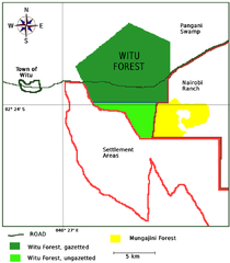
English: Map showing the Witu Forest, Kenya, with gazetted and ungazetted lands, the town of Witu, and the relationship to the Nairobi ranch, the Mungajini Forest, and the Pangani Swamp. Based upon data in Wacher, T. & Andanje, S. 2004. Kipini Wildlife and Botanical Conservancy: Feasibility Study – the potential role of Kipini Wildlife and Botanical Conservancy in the conservation and development of wildlife and natural resources; Lamu, Ijare and Tana districts, Kenya. Embassy of Finland, Nairobi, Kipini Wildlife and Botanical Conservancy Trust. and Neilsen, , Martin R. and Sick, Claudia (2008). Conservation and Use of Witu Forest, Kenya: Biodiversity and Disturbance Survey and Management Recommendations. Copenhagen: Danish Zoological Societ.ISBN 978-87-7056-027-6. |
|||
| Date | ||||
| Source | Own work | |||
| Author | Bejnar | |||
| Permission (Reusing this file) |
|
Licensing
I, the copyright holder of this work, hereby publish it under the following license:
| This file is made available under the Creative Commons CC0 1.0 Universal Public Domain Dedication. | |
| The person who associated a work with this deed has dedicated the work to the public domain by waiving all of their rights to the work worldwide under copyright law, including all related and neighboring rights, to the extent allowed by law. You can copy, modify, distribute and perform the work, even for commercial purposes, all without asking permission.
|
File history
Click on a date/time to view the file as it appeared at that time.
| Date/Time | Thumbnail | Dimensions | User | Comment | |
|---|---|---|---|---|---|
| current | 05:35, 7 August 2012 | | 933 × 1,068 (62 KB) | Bejnar | {{Information |Description ={{en|1=Map showing the Witu Forest, Kenya, with gazetted and ungazetted lands, the town of Witu, and the relationship to the Nairobi ranch, the Mungajini Forest, and the Pangani Swamp. Based upon data in Wacher, T. & And... |
File usage
The following pages on the English Wikipedia use this file (pages on other projects are not listed):
Global file usage
The following other wikis use this file:
- Usage on ml.wikipedia.org
- Usage on sw.wikipedia.org