
File:Wheatley map.png

Size of this preview: 596 × 600 pixels. Other resolutions: 238 × 240 pixels | 477 × 480 pixels | 784 × 789 pixels.
Original file (784 × 789 pixels, file size: 81 KB, MIME type: image/png)
| This image may not have the proper copyright or licensing information, or there is a conflict of license. An experienced editor should contact the uploader and add the proper tag, or discuss the issue on the talk page. If the image has no source, add {{subst:Di-no source}}. If the image has no licensing information, add {{subst:Di-no license}}. If the copyright tag may need discussion, please list at Wikipedia:Files for discussion. |
Summary[edit]
| Description |
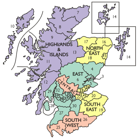
Map of the regions and districts of Scotland proposed by the Commission on Local Government in Scotland 1966–1969 in the Wheatley Report. |
|---|---|
| Source |
Own work |
| Date | |
| Author | |
| Permission (Reusing this file) |
See below.
|
Captioned As[edit]
| Page | Caption |
|---|---|
| Royal Commission on Local Government in Scotland | The regions and districts proposed by the Wheatley Commission |
Licensing[edit]
| I, the copyright holder of this work, hereby release it into the public domain. This applies worldwide. If this is not legally possible: |
File history
Click on a date/time to view the file as it appeared at that time.
| Date/Time | Thumbnail | Dimensions | User | Comment | |
|---|---|---|---|---|---|
| current | 14:21, 15 July 2009 | | 784 × 789 (81 KB) | Lozleader (talk | contribs) | Map of the regions and districts of Scotland proposed by the Commission on Local Government in Scotland 1966–1969 in the Wheatley Report. |
You cannot overwrite this file.
File usage
The following pages on the English Wikipedia use this file (pages on other projects are not listed):