
File:Wales Administrative Map 2009.png
Size of this preview: 380 × 599 pixels. Other resolutions: 152 × 240 pixels | 304 × 480 pixels | 487 × 768 pixels | 649 × 1,024 pixels | 2,150 × 3,389 pixels.
Original file (2,150 × 3,389 pixels, file size: 1.09 MB, MIME type: image/png)
| This is a file from the Wikimedia Commons. Information from its description page there is shown below. Commons is a freely licensed media file repository. You can help. |
Summary
| Description |
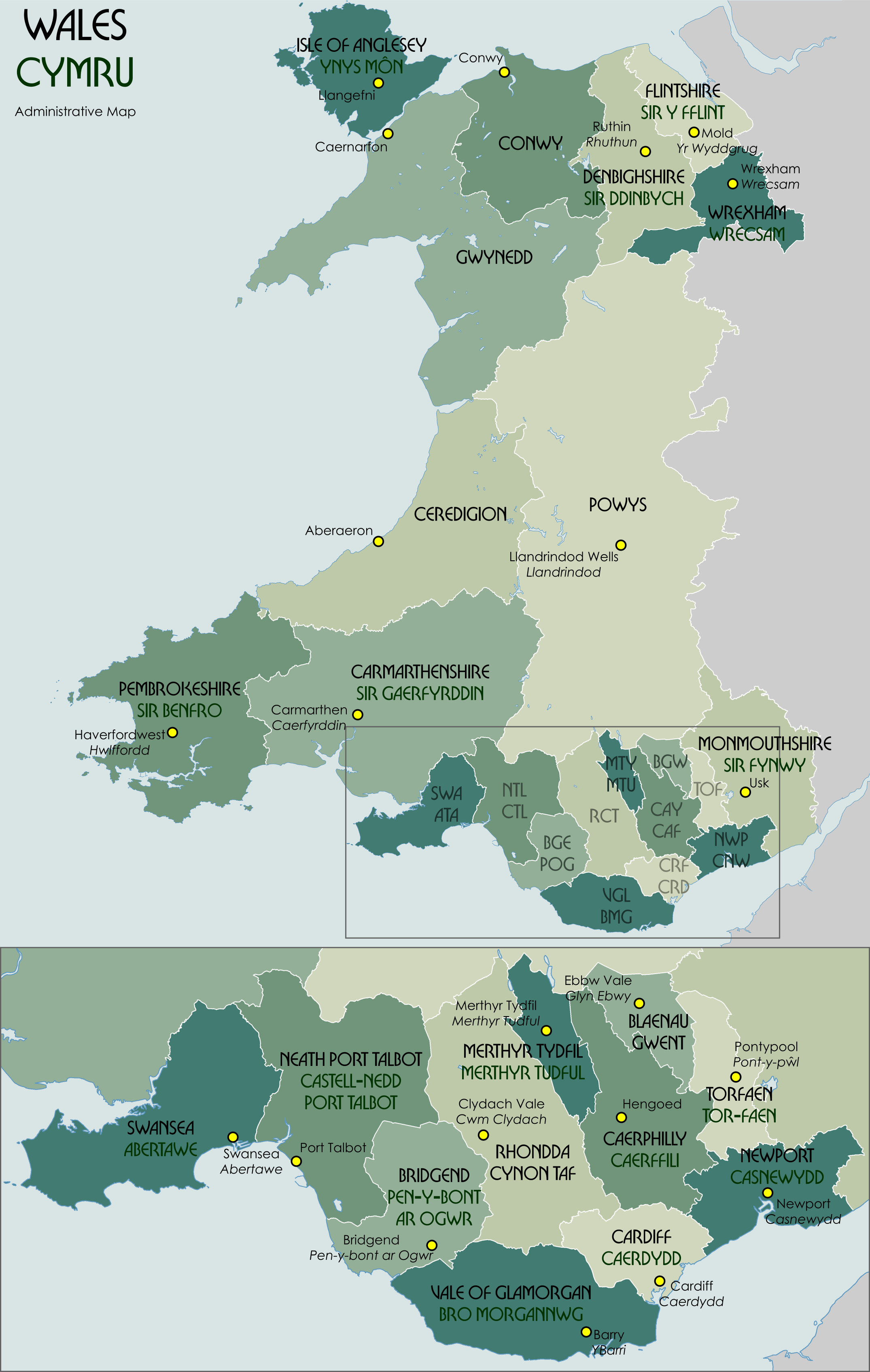
English: Administrative map showing the unitary authorities of Wales and their administrative HQs. |
| Date | |
| Source | Own work |
| Author | XrysD |
Code for clickable map

Licensing
I, the copyright holder of this work, hereby publish it under the following license:

|
Permission is granted to copy, distribute and/or modify this document under the terms of the GNU Free Documentation License, Version 1.2 or any later version published by the Free Software Foundation; with no Invariant Sections, no Front-Cover Texts, and no Back-Cover Texts. A copy of the license is included in the section entitled GNU Free Documentation License. |
File history
Click on a date/time to view the file as it appeared at that time.
| Date/Time | Thumbnail | Dimensions | User | Comment | |
|---|---|---|---|---|---|
| current | 12:33, 30 November 2021 | | 2,150 × 3,389 (1.09 MB) | XrysD | Correct version |
| 12:28, 30 November 2021 |  | 2,150 × 3,389 (951 KB) | XrysD | Fixed typo (Gaerfyddin->Caerfyrddin for the city) | |
| 17:43, 25 May 2016 |  | 2,150 × 3,389 (1.18 MB) | XrysD | Change Monmouthshire admin HQ from Cwmbran to Usk. | |
| 18:22, 26 September 2012 |  | 2,150 × 3,389 (1.16 MB) | XrysD | Fixed typo (Gaerfyddin->Gaerfyrddin) | |
| 11:51, 26 September 2012 |  | 2,150 × 3,389 (1.14 MB) | Citypeek | removal watermark | |
| 22:18, 3 September 2010 |  | 2,150 × 3,389 (1.17 MB) | XrysD | Fixed order of NTL/CTL ISO 3166-2 code. | |
| 22:09, 3 September 2010 |  | 2,150 × 3,389 (1.17 MB) | XrysD | Fixed Torfaen so that English/Welsh names in correct order. Minor change to title font size. | |
| 21:54, 3 September 2010 |  | 2,150 × 3,389 (1.17 MB) | XrysD | Changed Celtic Hand font to Bullion to improve legibility. Rationalised names so that format is English over Welsh for UA and admin centres. Changed Welsh UA names to green colour adopting system used for railway signs in Wales. | |
| 11:18, 16 January 2010 |  | 2,150 × 3,389 (1.12 MB) | XrysD | Made spelling corrections and colour changes | |
| 10:03, 16 January 2010 |  | 2,150 × 3,389 (1.13 MB) | XrysD | Removed Cardiganshire as alternative name for Ceredigion. Added sig. Moved label for Swansea slightly. |
File usage
The following pages on the English Wikipedia use this file (pages on other projects are not listed):
Global file usage
The following other wikis use this file:
- Usage on af.wikipedia.org
- Usage on ar.wikipedia.org
- Usage on ast.wikipedia.org
- Usage on bxr.wikipedia.org
- Usage on ca.wikipedia.org
- Usage on cy.wikipedia.org
- Usage on es.wikipedia.org
- Usage on eu.wikipedia.org
- Usage on fa.wikipedia.org
- Usage on fi.wikipedia.org
- Usage on fr.wikipedia.org
- Usage on fr.wiktionary.org
- Usage on ga.wikipedia.org
- Usage on gd.wikipedia.org
- Usage on id.wikipedia.org
- Usage on is.wikipedia.org
- Usage on it.wikipedia.org
- Usage on ja.wikipedia.org
- Usage on kn.wikipedia.org
- Usage on ko.wikipedia.org
- Usage on lld.wikipedia.org
- Usage on mn.wikipedia.org
- Usage on mt.wikipedia.org
- Usage on mzn.wikipedia.org
- Usage on nl.wikipedia.org
- Usage on no.wikipedia.org
- Usage on ps.wikipedia.org
- Usage on sco.wikipedia.org
- Usage on simple.wikipedia.org
- Usage on sr.wikipedia.org
- Usage on test2.wikipedia.org
- Usage on tr.wikipedia.org
- Usage on vi.wikipedia.org
- Usage on zh.wikipedia.org