
File:PIA00265 Venus - False Color of Volcanic Plains.jpg
Size of this preview: 800 × 512 pixels. Other resolutions: 320 × 205 pixels | 640 × 409 pixels | 1,024 × 655 pixels | 1,280 × 818 pixels | 2,560 × 1,637 pixels | 3,306 × 2,114 pixels.
Original file (3,306 × 2,114 pixels, file size: 1.56 MB, MIME type: image/jpeg)
| This is a file from the Wikimedia Commons. Information from its description page there is shown below. Commons is a freely licensed media file repository. You can help. |
Summary
| Description |
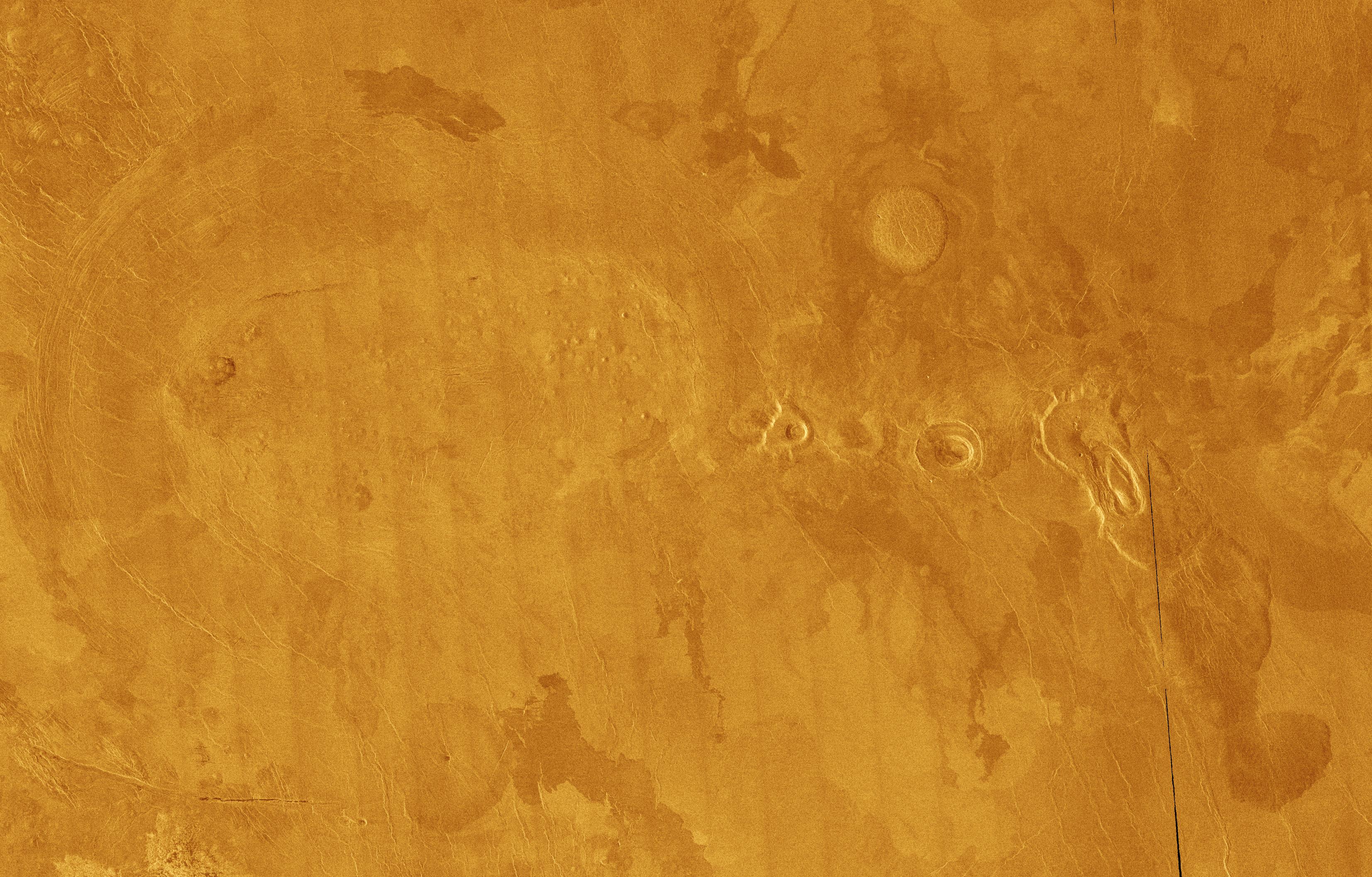
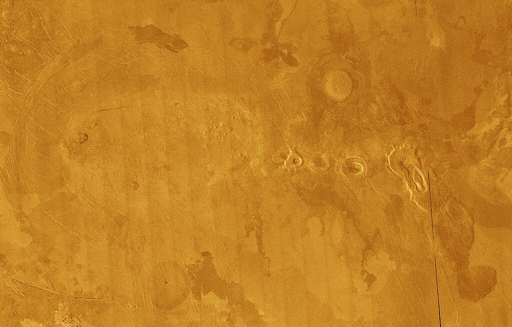
English: This Magellan full-resolution mosaic of Venus, centered at 10 degrees north latitude, 301 degrees east longitude, shows an area replete with diverse volcanic features. The image, of an area 489 kilometers long by 311 kilometers wide (303 by 193 miles), is dominated by volcanic plains which appear mottled because of varying roughnesses of each solidified lava flow. The rougher the terrain the brighter it appears in the radar image. The small, bright bumps clustered in the left portion of the image are a grouping of small volcanoes called a shield field. Each shield volcano is approximately 2 to 5 kilometers (1.2 to 3.1 miles) in diameter and has very subdued relief. It is believed that the lava flows that make up each shield originates from a common source. To the right of the shield field is another type of volcano, called a scalloped dome. It is 25 kilometers (16 miles) in diameter and has a central pit. Some of the indistinct lobe-shaped pattern around the dome may either be lava flows or rocky debris which has fallen from the scalloped cliffs surrounding the domes. The small radial ridges characteristic of scalloped domes are remnants of catastrophic landslides. To the right of that feature is a large depression called a volcanic caldera. The caldera was formed when lava was expelled from an underground chamber, which when emptied, subsequently collapsed forming the depression. The feature furthermost to the east (right) is another scalloped dome, 35 kilometers (22 miles) in diameter. That feature is unusual in that lava came out through the southeastern margin, rafting a large portion of the dome for 20 kilometers (12 miles). The lava continues into the lower right portion of the area in the image. Its steep rounded boundaries suggest it was a very sticky, oozing lava. That same type of lava is what scientists propose formed the steep-sided domes such as the bright, round feature, slightly northeast of center. It is highly likely that the features are all part of a single volcanic complex, where a large body of molten rock formed beneath the surface feeding each of the volcanoes above. The presence of fractures in the west, partially surrounding the volcanoes supports this theory. |
| Date | |
| Source | https://photojournal.jpl.nasa.gov/catalog/PIA00265 |
| Author | NASA/JPL |
Licensing
| This file is in the public domain in the United States because it was solely created by NASA. NASA copyright policy states that "NASA material is not protected by copyright unless noted". (See Template:PD-USGov, NASA copyright policy page or JPL Image Use Policy.) | ||
 |
Warnings:
|
File history
Click on a date/time to view the file as it appeared at that time.
| Date/Time | Thumbnail | Dimensions | User | Comment | |
|---|---|---|---|---|---|
| current | 09:50, 5 May 2024 | | 3,306 × 2,114 (1.56 MB) | PlanetUser | {{Information |Description={{en|This Magellan full-resolution mosaic of Venus, centered at 10 degrees north latitude, 301 degrees east longitude, shows an area replete with diverse volcanic features. The image, of an area 489 kilometers long by 311 kilometers wide (303 by 193 miles), is dominated by volcanic plains which appear mottled because of varying roughnesses of each solidified lava flow. The rougher the terrain the brighter it appears in the radar image. The small, bright bumps cluste... |
File usage
The following pages on the English Wikipedia use this file (pages on other projects are not listed):